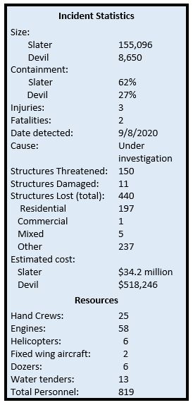
Slater and Devil Fires Update
Monday, October 5, 2020; 9:00 a.m.
Slater Fire – 155,096 acres and 62%
containment
Crews are clearing hazard trees on steep slopes along both sides of the Grayback Road between Takilma and Happy Camp. This high-priority work is required to provide safe, reliable access for firefighters, residents, and those working to restore power to Happy Camp.
On the north and northwest flanks of the fire, from the California border north and east to Holland, crews are mopping up and extending the depth of containment line. On the northeast side of the fire, crews are working to build containment lines towards Swan Mountain. The east side of the fire is holding west of the Thompson Creek drainage.
Firefighters are also extending the depth of mop up and patrol efforts on the southern flank of the fire, while putting out smoldering stumps and hot spots within fire lines where needed.
On the southwest side of the fire, firefighters are looking for containment opportunities in the Sanger Peak area, while extending mop up and patrol work along Sanger Peak Road.
Both direct and indirect tactics are being used on the west side of the fire to prevent westward movement. Firefighters will continue to bring the fire down to containment lines in the Knopki Creek area east of Hwy 199.
Devil Fire - 8,650 acres and 27% containment
Mop up and patrol continue along the northern and southern areas of the fire, with lines holding along the Applegate River, 1040 Road, and Pacific Crest Trail. There is active fire in a snag patch to the east, but containment lines are holding. Crews will patrol the southwest flank, working on direct line into the Fort Goff Creek area.
Weather and Fire BehaviorTemperatures will be slightly warmer tomorrow, with a trend toward
slightly lower humidity. Winds will be out
of the northeast, switching to the west/northwest in the afternoon. Some increase of interior burning is expected,
with smoke remaining on the western edge of the fire, reducing visibility.
Evacuations
Josephine
County information: 541-474-5305 or www.facebook.com/josephinecountyEM,
www.co.josephine.or.us/fire,
or www.rvem.org
Siskiyou County information: (530) 841-2900 or www.facebook.com/SiskiyouCountySheriff/
Del Norte County information: (707) 464-7213 or www.facebook.com/DelNorteOfficeOfEmergencyServices and www.preparedelnorte.com/
Closures: The USDA Forest Service-Pacific Southwest Region’s Order, that closed some national forests in California, has been lifted for the Six Rivers and Klamath National Forests; however, new fire area closure orders have been issued by these forests for the Slater Fire area in California. The region is under emergency fire restrictions, although the use of gas stoves is now allowed in open developed recreation sites. Find updated closure orders and maps at: www.fs.usda.gov/klamath and www.fs.usda.gov/srnf.
Portions of both the Rogue River-Siskiyou National Forest’s Wild Rivers Ranger District and Siskiyou Mountains Ranger District reopened for use. Some areas remain closed for emergency crews’ safety and to allow for fire suppression and burned area recovery. Find updated closure orders and maps at: www.fs.usda.gov/alerts/rogue-siskiyou/alerts-notices.
The Bureau of Land Management Medford District has public lands closures in effect near the Slater Fire and South Obenchain Fire. Closure area maps are available at: www.blm.gov/programs/public-safety-and-fire/fire-and-aviation/regional-info/oregon-washington/fire-restrictions.


No comments:
Post a Comment