

South Obenchain Fire Update
October 3, 2020 - FINAL
Fire Information
Wildfire Information Center: (458) 206-3043 https://southwestoregonwildfireinformation.blogspot.com/
Jackson County Emergency Management: (541) 776-7338
Email: SouthObenchainFire@gmail.com
Facebook: https://www.facebook.com/SouthObenchainFire
Inciweb: https://inciweb.nwcg.gov/incident/7185
Air Quality: http://oregonsmoke.blogspot.com/
Transition Update: All resources assigned to the South Obenchain Fire will be under the direction of a Type 4 Incident Management Team from the local Medford BLM District starting 7 AM tomorrow (October 4, 2020). The focus for current and future resources assigned to the fire is to address post-fire damage holistically and provide stabilization to ensure public safety and prevent further degradation of the landscape.
*Note: Smoke and heat will likely remain within the fire’s perimeter and is a natural occurrence. While smoke from the area may be unnerving, the consumption of fuel within the perimeter is an important and typical event in fire ecology. Please only call 911 if a fire is seen outside of the perimeter. Contact the Wildland Fire Information Center (WIC) directly for future questions or information concerning this fire 458-206-3043.
Weather: High pressure will remain over the fire area through next week. The weather will stay warm and dry, with afternoon temperatures expected to be 5-10 degrees above normal with afternoon humidity’s in the 20% range. Winds will generally be light, with northwest breezes in the afternoon. Rainfall looks likely sometime Friday or Saturday with increasing chances of wetting rain amounts, but timing remains uncertain.
Resources: 205 total resources.
Evacuations: Evacuation orders for the South Obenchain Fire have been removed. Visit the Jackson County Emergency Management page: https://jacksoncountyor.org/emergency/News/News-Information for the most recent map of evacuation levels and updates.
Evacuee Resources: The evacuation shelter remains located at the Jackson County Expo Center, 1 Penninger Rd. in Central Point, Oregon where some services are available. Multi-Agency Resource Centers (MARC) are open in Medford with smaller satellite offices operating in Talent, and Phoenix. MARC locations are available from 8 am – 8 pm, seven days a week.
Medford: Central High School, located at 815 S. Oakdale Avenue (541) 842-3669
Talent: Talent Elementary School, located at 307 Wagner Creek Road (541) 535-1531
Phoenix: Phoenix Civic Center, located at 220 N. Main Street (541) 535-1955 ext. 303
Temporary Flight Restrictions (TFR): The TFR remains in place for the safety of the firefighters and aircraft fighting the South Obenchain fire. Please consult the Notice to Airman for specifics.
Closures: Bureau of Land Management (BLM) has reduced the size of the public lands closure area related to the South Obenchain Fire. However, it is critical that the public understand that suppression and repair activities will continue for weeks. Public access in and around the fire continues to pose a safety concern for the community and firefighters. Updated maps of the closure areas are available on the BLM’s site: https://www.blm.gov/programs/public-safety-and-fire/fire-and-aviation/regional-info/oregonwashington/fire-restrictions
Lastly…
THANK YOU FROM NORTHEAST WASHINGTON INCIDENT MANAGEMENT TEAM 2!
It has been an honor to serve your wonderful community, and we wish each one of you a safe recovery.


Printable version of today's update can be found here
Printable version of today's map can be found here

South Obenchain Fire Update
October 2, 2020
Fire Information
Wildfire Information Center: (458) 206-3043 https://southwestoregonwildfireinformation.blogspot.com/
Jackson County Emergency Management: (541) 776-7338
Email: SouthObenchainFire@gmail.com
Facebook: https://www.facebook.com/SouthObenchainFire
Inciweb: https://inciweb.nwcg.gov/incident/7185
Air Quality: http://oregonsmoke.blogspot.com/
Update: Resources assigned to the South Obenchain Fire continue to draw down as the incident’s focuschanged from suppression work to primarily mop-up and repair work.
Weather: Weather today was sunny with temperatures in the high 80s. This evening an inversion is expected over the fire area and relative humidity’s will increase significantly. Smoke from local fires is expected to stay loft but may mix down to the surface.
Resources: 234 total resources. 4 type-2 crews, one light helicopter, four medium helicopters, one fixed-wing air tanker, one air attack, 14 engines, one dozer, three water tenders, and two skidgens.
Evacuations: Evacuation orders for the South Obenchain Fire have been removed. Visit the Jackson County Emergency Management page: https://jacksoncountyor.org/emergency/News/News-Information for the most recent map of evacuation levels and updates.
Evacuee Resources: The evacuation shelter remains located at the Jackson County Expo Center, 1 Penninger Rd. in Central Point, Oregon where some services are available. Multi-Agency Resource Centers (MARC) are open in Medford with smaller satellite offices operating in Talent, and Phoenix. MARC locations are available from 8 am – 8 pm, seven days a week.
Medford: Central High School, located at 815 S. Oakdale Avenue (541) 842-3669
Talent: Talent Elementary School, located at 307 Wagner Creek Road (541) 535-1531
Phoenix: Phoenix Civic Center, located at 220 N. Main Street (541) 535-1955 ext. 303
Temporary Flight Restrictions (TFR): The TFR remains in place for the safety of the firefighters and aircraft fighting the South Obenchain fire. Please consult the Notice to Airman for specifics.
Closures: Bureau of Land Management (BLM) has reduced the size of the public lands closure area related to the South Obenchain Fire. However, it is critical that the public understand that suppression and repair activities will continue for weeks. Public access in and around the fire continues to pose a safety concern for the community and firefighters. Updated maps of the closure areas are available on the BLM’s site: https://www.blm.gov/programs/public-safety-and-fire/fire-and-aviation/regional-info/oregonwashington/fire-restrictions


Printable version of today's update can be found here
Printable version of today's map can be found here

South Obenchain Fire Update
October 1, 2020
Fire Information
Wildfire Information Center: (458) 206-3043 https://southwestoregonwildfireinformation.blogspot.com/
Jackson County Emergency Management: (541) 776-7338
Email: SouthObenchainFire@gmail.com
Facebook: https://www.facebook.com/SouthObenchainFire
Inciweb: https://inciweb.nwcg.gov/incident/7185
Air Quality: http://oregonsmoke.blogspot.com/
Update: Some light smoke has been visible within the perimeter of the fire and poses no threat. Engines and hand-crews will continue today, mopping up the South Obenchain Fire. A suppression repair team is deployed to improve the landscape and repair dozer berms. Repair work can be laborious and frequently challenging to access. The repair team's goal is to repair the land back to its natural state before suppression efforts began.
Weather: Today is sunny with temperatures will be in the 90s and humidity in 20’s. Smoke from fires to the south are continuing to drift over the area.
Resources: 357 total resources. nine type-2 crews, one light helicopter, two medium helicopters, one fixed wing air tanker, one air attack, 21 engines, four dozers, eight water tenders, and two skidgens.
Evacuations: Evacuation orders for the South Obenchain Fire have been removed. Visit the Jackson County Emergency Management page: https://jacksoncountyor.org/emergency/News/News-Information for the most recent map of evacuation levels and updates.
Evacuee Resources: The evacuation shelter remains located at the Jackson County Expo Center, 1 Penninger Rd. in Central Point, Oregon where some services are available. Multi-Agency Resource Centers (MARC) are open in Medford with smaller satellite offices operating in Talent, and Phoenix. MARC locations are available from 8 am – 8 pm, seven days a week.
Medford: Central High School, located at 815 S. Oakdale Avenue (541) 842-3669
Talent: Talent Elementary School, located at 307 Wagner Creek Road (541) 535-1531
Phoenix: Phoenix Civic Center, located at 220 N. Main Street (541) 535-1955 ext. 303
Temporary Flight Restrictions (TFR): The TFR remains in place for the safety of the firefighters and aircraft fighting the South Obenchain fire. Please consult the Notice to Airman for specifics.
Closures: Bureau of Land Management (BLM) has reduced the size of the public lands closure area related to the South Obenchain Fire. However, it is critical that the public understand that suppression and repair activities are still ongoing. Public access in and around the fire continues to poses a safety concern for the community and firefighters. Updated maps of the closure areas are available on the BLM’s site: https://www.blm.gov/programs/public-safety-and-fire/fire-and-aviation/regional-info/oregonwashington/ fire-restrictions


Printable version of today's update can be found herePrintable version of today's map can be found here

South Obenchain Fire Update
September 29, 2020
Update: Yesterday, the red flag warning and easterly winds tested the brush and oak in the area, but no active flames flared up and there was no threat to containment on the South Obenchain Fire. Crews are actively engaged in mop up and suppression repair work in Division U on the southeastern flank, ensuring no heat exists within 300 feet of the established fire perimeter. Hose lays are still being used in this section, and crews are breaking up dozer berms that were put in to control the fire early on during the incident. Smokes are still found in the deep interior of the fire.
Weather: Very warm temperatures and dry and unstable conditions are expected over the burn area through much of the week, with little day-to-day variation in the forecast. Winds will be light and mostly terrain/diurnally driven. Temperatures and humidities will vary slightly and gradually moderate by the end of the week. There are no precipitation chances through the weekend and low humidity levels. Temperatures will be in the 90s today.
Resources: 380 total resources. 12 type-2 crews, one light helicopter, two medium helicopters, one fixed-wing air tanker, one air attack, 21 engines, four dozers, eight water tenders, and three skidgens.
Evacuations: Properties east of North and South Obenchain Roads within the burn area are reduced to Level 1. All other areas impacted by the Obenchain fire are no longer under an evacuation order. Visit the Jackson County Emergency Management page: https://jacksoncountyor.org/emergency/News/News-Information for a map of evacuation levels and updates.
Evacuee Resources: The evacuation shelter remains located at the Jackson County Expo Center, 1 Penninger Rd. in Central Point, Oregon where some services are available. Multi-Agency Resource Centers (MARC) are now open in Medford with smaller satellite offices operating in Talent, and Phoenix. MARC locations will be available from 8 am – 8 pm, seven days a week.
Medford: Central High School, located at 815 S. Oakdale Avenue (541) 842-3669
Talent: Talent Elementary School, located at 307 Wagner Creek Road (541) 535-1531
Phoenix: Phoenix Civic Center, located at 220 N. Main Street (541) 535-1955 ext. 303
Temporary Flight Restrictions: The footprint of the TFR has reduced in size and height. It remains in place for the safety of the firefighters and aircraft fighting the South Obenchain fire. Please consult the Notice to Airman for specifics.
Closure: All Bureau of Land Management lands within the fire perimeter remain closed. The public must not enter closure areas and closed recreation sites. Maps of the closure areas are available on the Bureau of Land Management’s website: http://www.blm.gov/programs/public-safety-and-fire/fire-and-aviation/regional-info/oregon-washington/fire-restrictions

Wildfire
Information Center: (458) 206-3043 https://southwestoregonwildfireinformation.blogspot.com/
Jackson
County Emergency Management: (541) 776-7338
Email: SouthObenchainFire@gmail.com
Air Quality:
http://oregonsmoke.blogspot.com/


South Obenchain Fire Update
September 28, 2020
Update: Today is a “watch out” day for firefighters to stay aware of shifting winds that can carry heat to unburned areas of the fire. Large pockets of brush, trees, and grass that have not burned within the fire are called isolated islands. Since there is potential for the islands to burn, crews establish control lines around them and monitor for new smokes or interior heat. Containment and control lines continue to hold on the South Obenchain Fire. There is no threat to containment. Excess equipment and supplies are being backhauled to camp.
Weather: A red flag warning is in effect until Tuesday at 10am. Gusty winds are coming from the east at 4 -12 mph with gusts reaching up to 27 mph on ridgetops. Today is sunny with maximum temperature around 93 degrees at lower elevations, and around 85 degrees above 3,000 feet. There is low humidity across much of far southwestern Oregon. Winds will weaken tonight into Tuesday, but dry and warm conditions will continue into the week.
Resources: 391 total resources. 12 type-2 crews, one light helicopter, two medium helicopters, one fixed-wing air tanker, 21 engines, four dozers, eight water tenders, and three skidgens.
Evacuations: Properties east of North and South Obenchain Roads within the burn area are reduced to Level 1. All other areas impacted by the Obenchain fire are no longer under an evacuation order. Visit the Jackson County Emergency Management page: https://jacksoncountyor.org/emergency/News/News-Information for a map of evacuation levels and updates.
Evacuee Resources: The evacuation shelter remains located at the Jackson County Expo Center, 1 Penninger Rd. in Central Point, Oregon where some services are available. Multi-Agency Resource Centers (MARC) are now open in Medford with smaller satellite offices operating in Talent, and Phoenix. MARC locations will be available from 8 am – 8 pm, seven days a week.
Medford: Central High School, located at 815 S. Oakdale Avenue (541) 842-3669
Talent: Talent Elementary School, located at 307 Wagner Creek Road (541) 535-1531
Phoenix: Phoenix Civic Center, located at 220 N. Main Street (541) 535-1955 ext. 303
Temporary Flight Restrictions: The footprint of the TFR has reduced in size and height. It remains in place for the safety of the firefighters and aircraft fighting the South Obenchain fire. Please consult the Notice to Airman for specifics.
Closure: All Bureau of Land Management lands within the fire perimeter remain closed. The public must not enter closure areas and closed recreation sites. Maps of the closure areas are available on the Bureau of Land Management’s website: http://www.blm.gov/programs/public-safety-and-fire/fire-and-aviation/regional-info/oregon-washington/fire-restrictions


Wildfire Information Center: (458) 206-3043 https://southwestoregonwildfireinformation.blogspot.com/
Jackson County Emergency Management: (541) 776-7338
Email: SouthObenchainFire@gmail.com
Air Quality: http://oregonsmoke.blogspot.com/

Printable version of today's update can be found herePrintable version of today's map can be found here

South Obenchain Fire Update
September 27, 2020
Update: Containment and control lines are holding well on the South Obenchain Fire. Crews are patrolling all edges of the fire and using a “seek and destroy” approach to search for remaining heat near the fire perimeter. Firefighters are removing water handling equipment and hose lays on sections of contained line. It is a priority to solidify lines before the winds shift and temperatures build starting this evening.
Fire Weather and Activity: Humidity is roughly 30 percent lower than yesterday, with much drier and breezier conditions. Light winds from the east will gradually increase and turn northeast. A red flag weather warning is in effect starting at midnight tonight through Monday evening. These warmer, windier, and drier conditions increase the chance of building fire behavior. Stump holes and large diameter fuels will continue burning, and duff in the pine layer is smoldering.
Resources: 393 total resources. 12 type-2 crews, two light helicopters, two medium helicopters, one fixed-wing air tanker, 21 engines, six dozers, nine water tenders, and three skidgens.
Evacuations: Properties east of North and South Obenchain Roads within the burn area are reduced to Level 1. All other areas impacted by the Obenchain fire are no longer under an evacuation order. Visit the Jackson County Emergency Management page: https://jacksoncountyor.org/emergency/News/News-Information for a map of evacuation levels and updates.
Evacuee Resources: The evacuation shelter remains located at the Jackson County Expo Center, 1 Penninger Rd. in Central Point, Oregon where care and services are available such as food, medical care, bathrooms and showers. Multi-Agency Resource Centers (MARC) are now open in Medford with smaller satellite offices operating in Talent, and Phoenix. All four MARC locations will be available from 8 am – 8 pm, seven days a week.
Medford: Central High School, located at 815 S. Oakdale Avenue (541) 842-3669
Talent: Talent Elementary School, located at 307 Wagner Creek Road (541) 535-1531
Phoenix: Phoenix Civic Center, located at 220 N. Main Street (541) 535-1955 ext. 303
Temporary Flight Restrictions: The footprint of the TFR has reduced in size and height. It remains in place for the safety of the firefighters and aircraft fighting the South Obenchain fire. Please consult the Notice to Airman for specifics.
Closure: The Bureau of Land Management Medford District has closures in effect near the Slater Fire and the South Obenchain Fire. Maps of the closure areas are available on the Bureau of Land Management’s website: http://www.blm.gov/programs/public-safety-and-fire/fire-and-aviation/regional-info/oregon-washington/fire-restrictions


Wildfire Information Center: (458) 206-3043 https://southwestoregonwildfireinformation.blogspot.com/
Jackson County Emergency Management: (541) 776-7338
Email: SouthObenchainFire@gmail.com
Air Quality: http://oregonsmoke.blogspot.com/
 Printable version of today's update can be found herePrintable version of today's map can be found here

September 26, 2020Update: The South Obenchain Fire has transitioned from a Type 2 fire to a Type 3 fire. The Northeast Washington Team 2 with Incident Commander Dean Kiefer assumed management of the fire today at 7:00am. The number of resources assigned to the fire will adjust as fire behavior reduces and as needs shift.Firefighters will continue working to reduce hazards within the interior of the fire, install water bars, clean up dozer lines, and mop up. Focus remains on Division U as firefighters patrol for remaining heat and smoke. Resource Advisors are working with crews to complete suppression repair efforts which will reduce the potential impact from future rain and snow events, erosion and landslides. Potential hazards include trees with heavy and wet limbs and burned root structures.
The incident objectives remain the same. The life and safety of the public and all wildland fire responders is always the number one priority for all fire agencies. To keep firefighters and communities healthy and safe, all firefighters are asked to follow recommendations from the Centers for Disease Control and Prevention to reduce the spread of illness and COVID. This also includes limited entry into the incident command post and base camp.
Fire Weather: Today will be another cool and high humidity day, with clouds and scattered showers in the morning becoming partly cloudy with isolated showers in the afternoon. Temperatures will be slightly warmer than yesterday, at 70-75 degrees in the valleys and 62-67 at elevations above 2500 feet. Winds are from the west to northwest at 4-6 mph and gusting to 11 mph in the afternoon. Clear weather after sunset.
Fire Activity: Expect mild fire behavior today. Fire may creep, smolder, and have light surface fire under unburned protected canopies. All fuels remain at critically dry levels. Brush and grasses expect to dry out quickly as temperatures increase early next week.
Resources: 462 total resources. 12 type-2 crews, one light helicopter, two medium helicopters, 27 engines, five dozers, nine water tenders, and three skidgens.
Evacuations: Evacuation levels have been eliminated except for a Level 1 in the eastern end of the fire area. Please view the following web pages for the most current evacuation maps. Jackson County Emergency Management: https://jcgis.maps.arcgis.com/apps/webappviewer/index.html?id=3caa39804db54631a61007180d5ef415
Jackson County Sheriff’s Office: https://jacksoncountyor.org/sheriff
Shelter Location: The evacuation shelter remains located at the Jackson County Expo Center, 1 Penninger Rd. in Central Point, Oregon where care and services are available such as food, medical care, bathrooms and showers.
Temporary Flight Restrictions: The footprint of the TFR has reduced in size and height. It remains in place for the safety of the firefighters and aircraft fighting the South Obenchain fire. Please consult the Notice to Airman for specifics.
Closure: The Bureau of Land Management Medford District has rescinded public lands closure notices across much of the District. Public lands closures remain in effect near the Slater Fire and the South Obenchain Fire.
Maps of the closure areas are available on the Bureau of Land Management’s website: http://www.blm.gov/programs/public-safety-and-fire/fire-and-aviation/regional-info/oregon-washington/fire-restrictions
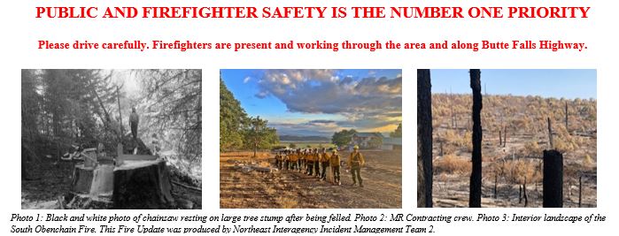
PUBLIC AND FIRE FIGHTER SAFETY IS THE NUMBER ONE PRIORITY
Be drive carefully. Firefighters are present and working through the area and along Butte Falls Highway.

This Fire Update was produced by Northeast Interagency Incident Management Team 2
Wildfire Information Center: (458) 206-3043 https://southwestoregonwildfireinformation.blogspot.com/
Jackson County Emergency Management: (541) 776-7338
Email: SouthObenchainFire@gmail.com
Air Quality: http://oregonsmoke.blogspot.com/


Printable version of today's update can be found herePrintable version of today's map can be found here
South Obenchain Fire Update
Northwest Incident Management Team 8, Incident Commander, Doug Johnson
September 25, 2020
This will be the last update from the Northwest Incident Management Team 8 (NWIMT8), Incident Commander Doug Johnson. NE Washington Team 2, Incident Commander Dean Kiefer, will assume management of the fire Saturday at 7:00 am. NWIMT8 would like to take this opportunity to say “thank you” to the communities, cooperators, agency staff, and firefighters for the unwavering support during our management of the South Obenchain Fire.
The life and safety of the public and all wildland fire responders is always the number one priority for all fire agencies. To keep firefighters and communities healthy and safe, all firefighters are asked to follow recommendations from the Centers for Disease Control and Prevention to reduce the spread of illness. This also includes limited entry into the incident command post and base camp.
The small amount of precipitation received has not significantly reduced the fire danger. All fuels remain at critically dry levels.Please stay diligent to keep new starts from occurring. Hunters are also reminded to be cautious and watch for falling fire weakened trees.
Fire Information: Wildfire Information Center: (458) 206-3043 Jackson County Emergency Management: (541) 776-7338 E-mail: SouthObenchainFire@gmail.com Wildfire Information Center: https://southwestoregonwildfireinformation.blogspot.com/ Air Quality: http://oregonsmoke.blogspot.com/ Acreage: 32,671 Containment: 90% Cause: Under investigation
Current situation: Visible flames and smoke will persist within the fire perimeter until a season-ending rain or snow event. Only call 911 if flames are actively spreading and life or property are threatened. Please provide a specific address or location for firefighters to respond.
Over 91 miles of containment line has been constructed to contain the South Obenchain Fire. Firefighting resources have been using the infrared technologies along these lines to find and mop-up any heat signatures. Due to safety risk concerns of working too far interior, a mop-up standard of 300 ft was determined by the local agencies. The 300 ft distance reduces the possibility that any live embers existing in the fire will not escape. Crews are continuing to patrol containment lines while looking for smokes in the interior. Along with that they will be mopping up, mitigating and rehabbing fire suppression actions. Many of these crews will be winding down their assignment here and demobilizing to leave for other incidents or headed home for well-earned rest.
There will still be firefighters present and working throughout the area and near roadways which should elicit caution from the public.
Resource Advisors are working with the repair group and continue to make good progress cleaning up dozer lines, repairing fencing, installing water bars, or ways to impede the flow of water down trails. and completing other suppression repairs. These measures will be important as the fall rains come.
The Northwest Incident Management Team 8 will be transitioning to the Northeast Washington Team 2 Saturday September 26, 2020 at 7 am.
Evacuations: Please view the following web pages for the most current evacuation maps: Jackson County Emergency Management: https://jcgis.maps.arcgis.com/apps/webappviewer/index.html?id=3caa39804db54631a61007180d5ef415
Jackson County Sheriff’s Office: https://jacksoncountyor.org/sheriff
Shelter Location: The evacuation shelter remains located at the Jackson County Expo Center, 1 Penninger Rd. in Central Point, Oregon where care and services are available such as food, medical care, bathrooms and showers.
Weather: It was 98 days of dry weather before Thursday’s rain. Another chance of rain is forecasted for late afternoon into the night. Temperatures will be near the mid-70’s with relative humidity of 45%. Winds will be southwest to west at 7 mph with gusts to 15 mph.
Resources-783: 2-type 2 initial attack crews, 25-type 2 crews, 1- light helicopter, 2-medium helicopters, 36-engines, 10-dozers, 13-water tenders and 4-skidgens.
Temporary Flight Restrictions: The footprint of the TFR has reduced in size and height. It remains in place for the safety of the firefighters and aircraft fighting the South Obenchain fire. Please consult the Notice to Airman for specifics.
Closure: Thanks to recent rains and an increase in availability of initial attack resources to respond to new starts, the Bureau of Land Management Medford District is rescinding public lands closure notices across much of the District. Public lands closures remain in effect near the Slater Fire and the South Obenchain Fire.
Maps of the closure areas are available on the Bureau of Land Management’s website: http://www.blm.gov/programs/public-safety-and-fire/fire-and-aviation/regional-info/oregon-washington/fire-restrictions
 Printable version of today's update can be found herePrintable version of today's map can be found here
South Obenchain Fire Update
Northwest Incident Management Team 8, Incident Commander, Doug Johnson
September 23, 2020
Fire updates will be provided once daily
The life and safety of the public and all wildland fire responders is always the number one priority for all fire agencies. To keep firefighters and communities healthy and safe, all firefighters are asked to follow recommendations from the Centers for Disease Control and Prevention to reduce the spread of illness. This also includes limited entry into the incident command post and base camp.
EXTREME fire danger still exists in the Rogue Valley. All fuels remain at critically dry levels. An innocent spark could escalate out of control. Please do your part to prevent wildfires. One less spark, one less wildfire.
Fire Information:
Wildfire Information Center: (458) 206-3043
Jackson County Emergency Management: (541) 776-7338
E-mail: SouthObenchainFire@gmail.com
Wildfire Information Center: https://southwestoregonwildfireinformation.blogspot.com/
Facebook: https://www.facebook.com/SouthObenchainFire
Inciweb: https://inciweb.nwcg.gov/incident/7185
Air Quality: http://oregonsmoke.blogspot.com/
Acreage: 32,671
Containment: 80%
Cause: Under investigation
Current situation: Visible flames and smoke will persist within the fire perimeter until a season-ending rain or snow event. Only call 911 if flames are actively spreading and life or property are threatened. Please provide a specific address or location for firefighters to respond.
Data received yesterday from the infrared mapping resources show the fire is still holding heat signatures such as stump holes and scattered concentrations of fuels. These interior islands will continue to consolidate. There is little to no open flames, however the continued dry fuels and approaching cold front with gusty winds from the west could challenge the eastern containment lines. Crews will remain vigilant and respond to any increased activity. Hazards for crews include fire weakened trees, snags, rolling debris, and additional local traffic.
As the fire continues, it is natural to get relaxed as evacuation levels persist. Evacuation levels are evaluated daily. Please remember this is an active fire and citizens need to remain aware that conditions could change.
Resource Advisors are working with the repair group and continue to make good progress cleaning up dozer lines, repairing fencing, installing water bars, and completing other suppression repairs.
The Northwest Incident Management Team #8 will be transitioning to the Northeast Washington Team #2 this Friday.
Evacuations: Portions of the evacuations levels have been reduced in some areas from a level 2 to a level 1. The Jackson County Sheriffs’ Office has removed the countywide level 1.
Please view the following web pages for the most current evacuation maps:
Jackson County Emergency Management:
https://jcgis.maps.arcgis.com/apps/webappviewer/index.html?id=3caa39804db54631a61007180d5ef415
Jackson County Sheriff’s Office:
https://jacksoncountyor.org/sheriff
Shelter Location: The evacuation shelter remains located at the Jackson County Expo Center, 1 Penninger Rd. in Central Point, Oregon where care and services are available such as food, medical care, bathrooms and showers.
Weather: Today will be breezy ahead of a cold front. Wednesday night into early Thursday there’s a good chance for rain with a chance of showers on Friday, possibly measuring 1/10th inch.
Resources-856: 1-type 1 hand crew, 1-type 2 initial attack crew, 26-type 2 crews, 1- light helicopter, 2-medium helicopters, 37-engines, 10-dozers, 21-water tenders and 4-skidgens.
Temporary Flight Restrictions: The footprint of the TFR has reduced in size and height. It remains in place for the safety of the firefighters and aircraft fighting the South Obenchain fire. Please consult the Notice to Airman for specifics.
Closure: The Bureau of Land Management Medford District has temporarily closed many areas of public lands to support fire suppression efforts and to prevent new starts.
Maps of the closure areas are available on the Bureau of Land Management’s website: http://www.blm.gov/programs/public-safety-and-fire/fire-and-aviation/regional-info/oregon-washington/fire-restrictions
 Printable version of Today's Update can be found herePrintable version of Today's Map can be found here
###
South Obenchain Fire Update

South Obenchain Fire Update
October 3, 2020 - FINAL
Fire Information
Wildfire Information Center: (458) 206-3043 https://southwestoregonwildfireinformation.blogspot.com/
Jackson County Emergency Management: (541) 776-7338
Email: SouthObenchainFire@gmail.com
Facebook: https://www.facebook.com/SouthObenchainFire
Inciweb: https://inciweb.nwcg.gov/incident/7185
Air Quality: http://oregonsmoke.blogspot.com/
Transition Update: All resources assigned to the South Obenchain Fire will be under the direction of a Type 4 Incident Management Team from the local Medford BLM District starting 7 AM tomorrow (October 4, 2020). The focus for current and future resources assigned to the fire is to address post-fire damage holistically and provide stabilization to ensure public safety and prevent further degradation of the landscape.
*Note: Smoke and heat will likely remain within the fire’s perimeter and is a natural occurrence. While smoke from the area may be unnerving, the consumption of fuel within the perimeter is an important and typical event in fire ecology. Please only call 911 if a fire is seen outside of the perimeter. Contact the Wildland Fire Information Center (WIC) directly for future questions or information concerning this fire 458-206-3043.
Weather: High pressure will remain over the fire area through next week. The weather will stay warm and dry, with afternoon temperatures expected to be 5-10 degrees above normal with afternoon humidity’s in the 20% range. Winds will generally be light, with northwest breezes in the afternoon. Rainfall looks likely sometime Friday or Saturday with increasing chances of wetting rain amounts, but timing remains uncertain.
Resources: 205 total resources.
Evacuations: Evacuation orders for the South Obenchain Fire have been removed. Visit the Jackson County Emergency Management page: https://jacksoncountyor.org/emergency/News/News-Information for the most recent map of evacuation levels and updates.
Evacuee Resources: The evacuation shelter remains located at the Jackson County Expo Center, 1 Penninger Rd. in Central Point, Oregon where some services are available. Multi-Agency Resource Centers (MARC) are open in Medford with smaller satellite offices operating in Talent, and Phoenix. MARC locations are available from 8 am – 8 pm, seven days a week.
Medford: Central High School, located at 815 S. Oakdale Avenue (541) 842-3669
Talent: Talent Elementary School, located at 307 Wagner Creek Road (541) 535-1531
Phoenix: Phoenix Civic Center, located at 220 N. Main Street (541) 535-1955 ext. 303
Temporary Flight Restrictions (TFR): The TFR remains in place for the safety of the firefighters and aircraft fighting the South Obenchain fire. Please consult the Notice to Airman for specifics.
Closures: Bureau of Land Management (BLM) has reduced the size of the public lands closure area related to the South Obenchain Fire. However, it is critical that the public understand that suppression and repair activities will continue for weeks. Public access in and around the fire continues to pose a safety concern for the community and firefighters. Updated maps of the closure areas are available on the BLM’s site: https://www.blm.gov/programs/public-safety-and-fire/fire-and-aviation/regional-info/oregonwashington/fire-restrictions
Lastly…
THANK YOU FROM NORTHEAST WASHINGTON INCIDENT MANAGEMENT TEAM 2!
It has been an honor to serve your wonderful community, and we wish each one of you a safe recovery.


South Obenchain Fire Update
October 2, 2020
Fire Information
Wildfire Information Center: (458) 206-3043 https://southwestoregonwildfireinformation.blogspot.com/
Jackson County Emergency Management: (541) 776-7338
Email: SouthObenchainFire@gmail.com
Facebook: https://www.facebook.com/SouthObenchainFire
Inciweb: https://inciweb.nwcg.gov/incident/7185
Air Quality: http://oregonsmoke.blogspot.com/
Update: Resources assigned to the South Obenchain Fire continue to draw down as the incident’s focuschanged from suppression work to primarily mop-up and repair work.
Weather: Weather today was sunny with temperatures in the high 80s. This evening an inversion is expected over the fire area and relative humidity’s will increase significantly. Smoke from local fires is expected to stay loft but may mix down to the surface.
Resources: 234 total resources. 4 type-2 crews, one light helicopter, four medium helicopters, one fixed-wing air tanker, one air attack, 14 engines, one dozer, three water tenders, and two skidgens.
Evacuations: Evacuation orders for the South Obenchain Fire have been removed. Visit the Jackson County Emergency Management page: https://jacksoncountyor.org/emergency/News/News-Information for the most recent map of evacuation levels and updates.
Evacuee Resources: The evacuation shelter remains located at the Jackson County Expo Center, 1 Penninger Rd. in Central Point, Oregon where some services are available. Multi-Agency Resource Centers (MARC) are open in Medford with smaller satellite offices operating in Talent, and Phoenix. MARC locations are available from 8 am – 8 pm, seven days a week.
Medford: Central High School, located at 815 S. Oakdale Avenue (541) 842-3669
Talent: Talent Elementary School, located at 307 Wagner Creek Road (541) 535-1531
Phoenix: Phoenix Civic Center, located at 220 N. Main Street (541) 535-1955 ext. 303
Temporary Flight Restrictions (TFR): The TFR remains in place for the safety of the firefighters and aircraft fighting the South Obenchain fire. Please consult the Notice to Airman for specifics.
Closures: Bureau of Land Management (BLM) has reduced the size of the public lands closure area related to the South Obenchain Fire. However, it is critical that the public understand that suppression and repair activities will continue for weeks. Public access in and around the fire continues to pose a safety concern for the community and firefighters. Updated maps of the closure areas are available on the BLM’s site: https://www.blm.gov/programs/public-safety-and-fire/fire-and-aviation/regional-info/oregonwashington/fire-restrictions


South Obenchain Fire Update
October 1, 2020
Fire Information
Wildfire Information Center: (458) 206-3043 https://southwestoregonwildfireinformation.blogspot.com/
Jackson County Emergency Management: (541) 776-7338
Email: SouthObenchainFire@gmail.com
Facebook: https://www.facebook.com/SouthObenchainFire
Inciweb: https://inciweb.nwcg.gov/incident/7185
Air Quality: http://oregonsmoke.blogspot.com/
Update: Some light smoke has been visible within the perimeter of the fire and poses no threat. Engines and hand-crews will continue today, mopping up the South Obenchain Fire. A suppression repair team is deployed to improve the landscape and repair dozer berms. Repair work can be laborious and frequently challenging to access. The repair team's goal is to repair the land back to its natural state before suppression efforts began.
Weather: Today is sunny with temperatures will be in the 90s and humidity in 20’s. Smoke from fires to the south are continuing to drift over the area.
Resources: 357 total resources. nine type-2 crews, one light helicopter, two medium helicopters, one fixed wing air tanker, one air attack, 21 engines, four dozers, eight water tenders, and two skidgens.
Evacuations: Evacuation orders for the South Obenchain Fire have been removed. Visit the Jackson County Emergency Management page: https://jacksoncountyor.org/emergency/News/News-Information for the most recent map of evacuation levels and updates.
Evacuee Resources: The evacuation shelter remains located at the Jackson County Expo Center, 1 Penninger Rd. in Central Point, Oregon where some services are available. Multi-Agency Resource Centers (MARC) are open in Medford with smaller satellite offices operating in Talent, and Phoenix. MARC locations are available from 8 am – 8 pm, seven days a week.
Medford: Central High School, located at 815 S. Oakdale Avenue (541) 842-3669
Talent: Talent Elementary School, located at 307 Wagner Creek Road (541) 535-1531
Phoenix: Phoenix Civic Center, located at 220 N. Main Street (541) 535-1955 ext. 303
Temporary Flight Restrictions (TFR): The TFR remains in place for the safety of the firefighters and aircraft fighting the South Obenchain fire. Please consult the Notice to Airman for specifics.
Closures: Bureau of Land Management (BLM) has reduced the size of the public lands closure area related to the South Obenchain Fire. However, it is critical that the public understand that suppression and repair activities are still ongoing. Public access in and around the fire continues to poses a safety concern for the community and firefighters. Updated maps of the closure areas are available on the BLM’s site: https://www.blm.gov/programs/public-safety-and-fire/fire-and-aviation/regional-info/oregonwashington/ fire-restrictions


South Obenchain Fire Update
September 29, 2020
Update: Yesterday, the red flag warning and easterly winds tested the brush and oak in the area, but no active flames flared up and there was no threat to containment on the South Obenchain Fire. Crews are actively engaged in mop up and suppression repair work in Division U on the southeastern flank, ensuring no heat exists within 300 feet of the established fire perimeter. Hose lays are still being used in this section, and crews are breaking up dozer berms that were put in to control the fire early on during the incident. Smokes are still found in the deep interior of the fire.
Weather: Very warm temperatures and dry and unstable conditions are expected over the burn area through much of the week, with little day-to-day variation in the forecast. Winds will be light and mostly terrain/diurnally driven. Temperatures and humidities will vary slightly and gradually moderate by the end of the week. There are no precipitation chances through the weekend and low humidity levels. Temperatures will be in the 90s today.
Resources: 380 total resources. 12 type-2 crews, one light helicopter, two medium helicopters, one fixed-wing air tanker, one air attack, 21 engines, four dozers, eight water tenders, and three skidgens.
Evacuations: Properties east of North and South Obenchain Roads within the burn area are reduced to Level 1. All other areas impacted by the Obenchain fire are no longer under an evacuation order. Visit the Jackson County Emergency Management page: https://jacksoncountyor.org/emergency/News/News-Information for a map of evacuation levels and updates.
Evacuee Resources: The evacuation shelter remains located at the Jackson County Expo Center, 1 Penninger Rd. in Central Point, Oregon where some services are available. Multi-Agency Resource Centers (MARC) are now open in Medford with smaller satellite offices operating in Talent, and Phoenix. MARC locations will be available from 8 am – 8 pm, seven days a week.
Medford: Central High School, located at 815 S. Oakdale Avenue (541) 842-3669
Talent: Talent Elementary School, located at 307 Wagner Creek Road (541) 535-1531
Phoenix: Phoenix Civic Center, located at 220 N. Main Street (541) 535-1955 ext. 303
Temporary Flight Restrictions: The footprint of the TFR has reduced in size and height. It remains in place for the safety of the firefighters and aircraft fighting the South Obenchain fire. Please consult the Notice to Airman for specifics.
Closure: All Bureau of Land Management lands within the fire perimeter remain closed. The public must not enter closure areas and closed recreation sites. Maps of the closure areas are available on the Bureau of Land Management’s website: http://www.blm.gov/programs/public-safety-and-fire/fire-and-aviation/regional-info/oregon-washington/fire-restrictions

|
Wildfire
Information Center: (458) 206-3043 https://southwestoregonwildfireinformation.blogspot.com/ |
|
Jackson
County Emergency Management: (541) 776-7338 |
|
Email: SouthObenchainFire@gmail.com |
|
Air Quality:
http://oregonsmoke.blogspot.com/ |


South Obenchain Fire Update
September 28, 2020
Update: Today is a “watch out” day for firefighters to stay aware of shifting winds that can carry heat to unburned areas of the fire. Large pockets of brush, trees, and grass that have not burned within the fire are called isolated islands. Since there is potential for the islands to burn, crews establish control lines around them and monitor for new smokes or interior heat. Containment and control lines continue to hold on the South Obenchain Fire. There is no threat to containment. Excess equipment and supplies are being backhauled to camp.
Weather: A red flag warning is in effect until Tuesday at 10am. Gusty winds are coming from the east at 4 -12 mph with gusts reaching up to 27 mph on ridgetops. Today is sunny with maximum temperature around 93 degrees at lower elevations, and around 85 degrees above 3,000 feet. There is low humidity across much of far southwestern Oregon. Winds will weaken tonight into Tuesday, but dry and warm conditions will continue into the week.
Resources: 391 total resources. 12 type-2 crews, one light helicopter, two medium helicopters, one fixed-wing air tanker, 21 engines, four dozers, eight water tenders, and three skidgens.
Evacuations: Properties east of North and South Obenchain Roads within the burn area are reduced to Level 1. All other areas impacted by the Obenchain fire are no longer under an evacuation order. Visit the Jackson County Emergency Management page: https://jacksoncountyor.org/emergency/News/News-Information for a map of evacuation levels and updates.
Evacuee Resources: The evacuation shelter remains located at the Jackson County Expo Center, 1 Penninger Rd. in Central Point, Oregon where some services are available. Multi-Agency Resource Centers (MARC) are now open in Medford with smaller satellite offices operating in Talent, and Phoenix. MARC locations will be available from 8 am – 8 pm, seven days a week.
Medford: Central High School, located at 815 S. Oakdale Avenue (541) 842-3669
Talent: Talent Elementary School, located at 307 Wagner Creek Road (541) 535-1531
Phoenix: Phoenix Civic Center, located at 220 N. Main Street (541) 535-1955 ext. 303
Temporary Flight Restrictions: The footprint of the TFR has reduced in size and height. It remains in place for the safety of the firefighters and aircraft fighting the South Obenchain fire. Please consult the Notice to Airman for specifics.
Closure: All Bureau of Land Management lands within the fire perimeter remain closed. The public must not enter closure areas and closed recreation sites. Maps of the closure areas are available on the Bureau of Land Management’s website: http://www.blm.gov/programs/public-safety-and-fire/fire-and-aviation/regional-info/oregon-washington/fire-restrictions


Wildfire Information Center: (458) 206-3043 https://southwestoregonwildfireinformation.blogspot.com/ |
Jackson County Emergency Management: (541) 776-7338 |
Email: SouthObenchainFire@gmail.com |
Air Quality: http://oregonsmoke.blogspot.com/ |


South Obenchain Fire Update
September 27, 2020
Update: Containment and control lines are holding well on the South Obenchain Fire. Crews are patrolling all edges of the fire and using a “seek and destroy” approach to search for remaining heat near the fire perimeter. Firefighters are removing water handling equipment and hose lays on sections of contained line. It is a priority to solidify lines before the winds shift and temperatures build starting this evening.
Fire Weather and Activity: Humidity is roughly 30 percent lower than yesterday, with much drier and breezier conditions. Light winds from the east will gradually increase and turn northeast. A red flag weather warning is in effect starting at midnight tonight through Monday evening. These warmer, windier, and drier conditions increase the chance of building fire behavior. Stump holes and large diameter fuels will continue burning, and duff in the pine layer is smoldering.
Resources: 393 total resources. 12 type-2 crews, two light helicopters, two medium helicopters, one fixed-wing air tanker, 21 engines, six dozers, nine water tenders, and three skidgens.
Evacuations: Properties east of North and South Obenchain Roads within the burn area are reduced to Level 1. All other areas impacted by the Obenchain fire are no longer under an evacuation order. Visit the Jackson County Emergency Management page: https://jacksoncountyor.org/emergency/News/News-Information for a map of evacuation levels and updates.
Evacuee Resources: The evacuation shelter remains located at the Jackson County Expo Center, 1 Penninger Rd. in Central Point, Oregon where care and services are available such as food, medical care, bathrooms and showers. Multi-Agency Resource Centers (MARC) are now open in Medford with smaller satellite offices operating in Talent, and Phoenix. All four MARC locations will be available from 8 am – 8 pm, seven days a week.
Medford: Central High School, located at 815 S. Oakdale Avenue (541) 842-3669
Talent: Talent Elementary School, located at 307 Wagner Creek Road (541) 535-1531
Phoenix: Phoenix Civic Center, located at 220 N. Main Street (541) 535-1955 ext. 303
Closure: The Bureau of Land Management Medford District has closures in effect near the Slater Fire and the South Obenchain Fire. Maps of the closure areas are available on the Bureau of Land Management’s website: http://www.blm.gov/programs/public-safety-and-fire/fire-and-aviation/regional-info/oregon-washington/fire-restrictions


Wildfire Information Center: (458) 206-3043 https://southwestoregonwildfireinformation.blogspot.com/ |
Jackson County Emergency Management: (541) 776-7338 |
Email: SouthObenchainFire@gmail.com |
Air Quality: http://oregonsmoke.blogspot.com/ |


Firefighters will continue working to reduce hazards within the interior of the fire, install water bars, clean up dozer lines, and mop up. Focus remains on Division U as firefighters patrol for remaining heat and smoke. Resource Advisors are working with crews to complete suppression repair efforts which will reduce the potential impact from future rain and snow events, erosion and landslides. Potential hazards include trees with heavy and wet limbs and burned root structures.
The incident objectives remain the same. The life and safety of the public and all wildland fire responders is always the number one priority for all fire agencies. To keep firefighters and communities healthy and safe, all firefighters are asked to follow recommendations from the Centers for Disease Control and Prevention to reduce the spread of illness and COVID. This also includes limited entry into the incident command post and base camp.
Fire Weather: Today will be another cool and high humidity day, with clouds and scattered showers in the morning becoming partly cloudy with isolated showers in the afternoon. Temperatures will be slightly warmer than yesterday, at 70-75 degrees in the valleys and 62-67 at elevations above 2500 feet. Winds are from the west to northwest at 4-6 mph and gusting to 11 mph in the afternoon. Clear weather after sunset.
Fire Activity: Expect mild fire behavior today. Fire may creep, smolder, and have light surface fire under unburned protected canopies. All fuels remain at critically dry levels. Brush and grasses expect to dry out quickly as temperatures increase early next week.
Resources: 462 total resources. 12 type-2 crews, one light helicopter, two medium helicopters, 27 engines, five dozers, nine water tenders, and three skidgens.
Evacuations: Evacuation levels have been eliminated except for a Level 1 in the eastern end of the fire area. Please view the following web pages for the most current evacuation maps. Jackson County Emergency Management: https://jcgis.maps.arcgis.com/apps/webappviewer/index.html?id=3caa39804db54631a61007180d5ef415
Jackson County Sheriff’s Office: https://jacksoncountyor.org/sheriff
Shelter Location: The evacuation shelter remains located at the Jackson County Expo Center, 1 Penninger Rd. in Central Point, Oregon where care and services are available such as food, medical care, bathrooms and showers.
Temporary Flight Restrictions: The footprint of the TFR has reduced in size and height. It remains in place for the safety of the firefighters and aircraft fighting the South Obenchain fire. Please consult the Notice to Airman for specifics.
Closure: The Bureau of Land Management Medford District has rescinded public lands closure notices across much of the District. Public lands closures remain in effect near the Slater Fire and the South Obenchain Fire.
Maps of the closure areas are available on the Bureau of Land Management’s website: http://www.blm.gov/programs/public-safety-and-fire/fire-and-aviation/regional-info/oregon-washington/fire-restrictions
PUBLIC AND FIRE FIGHTER SAFETY IS THE NUMBER ONE PRIORITY Be drive carefully. Firefighters are present and working through the area and along Butte Falls Highway.
| |||
This Fire Update was produced by Northeast Interagency Incident Management Team 2 |

Wildfire Information Center: (458) 206-3043 https://southwestoregonwildfireinformation.blogspot.com/ |
Jackson County Emergency Management: (541) 776-7338 |
Email: SouthObenchainFire@gmail.com |
Air Quality: http://oregonsmoke.blogspot.com/ |


South Obenchain Fire Update
Northwest Incident Management Team 8, Incident Commander, Doug Johnson
September 25, 2020
Northwest Incident Management Team 8, Incident Commander, Doug Johnson
September 23, 2020
Fire updates will be provided once daily
The life and safety of the public and all wildland fire responders is always the number one priority for all fire agencies. To keep firefighters and communities healthy and safe, all firefighters are asked to follow recommendations from the Centers for Disease Control and Prevention to reduce the spread of illness. This also includes limited entry into the incident command post and base camp.
EXTREME fire danger still exists in the Rogue Valley. All fuels remain at critically dry levels. An innocent spark could escalate out of control. Please do your part to prevent wildfires. One less spark, one less wildfire.
Fire Information:
Wildfire Information Center: (458) 206-3043
Jackson County Emergency Management: (541) 776-7338
E-mail: SouthObenchainFire@gmail.com
Wildfire Information Center: https://southwestoregonwildfireinformation.blogspot.com/
Facebook: https://www.facebook.com/SouthObenchainFire
Inciweb: https://inciweb.nwcg.gov/incident/7185
Air Quality: http://oregonsmoke.blogspot.com/
Acreage: 32,671
Containment: 80%
Cause: Under investigation
Data received yesterday from the infrared mapping resources show the fire is still holding heat signatures such as stump holes and scattered concentrations of fuels. These interior islands will continue to consolidate. There is little to no open flames, however the continued dry fuels and approaching cold front with gusty winds from the west could challenge the eastern containment lines. Crews will remain vigilant and respond to any increased activity. Hazards for crews include fire weakened trees, snags, rolling debris, and additional local traffic.
As the fire continues, it is natural to get relaxed as evacuation levels persist. Evacuation levels are evaluated daily. Please remember this is an active fire and citizens need to remain aware that conditions could change.
Resource Advisors are working with the repair group and continue to make good progress cleaning up dozer lines, repairing fencing, installing water bars, and completing other suppression repairs.
The Northwest Incident Management Team #8 will be transitioning to the Northeast Washington Team #2 this Friday.
Evacuations: Portions of the evacuations levels have been reduced in some areas from a level 2 to a level 1. The Jackson County Sheriffs’ Office has removed the countywide level 1.
Please view the following web pages for the most current evacuation maps:
Jackson County Emergency Management:
https://jcgis.maps.arcgis.com/apps/webappviewer/index.html?id=3caa39804db54631a61007180d5ef415
Jackson County Sheriff’s Office:
https://jacksoncountyor.org/sheriff
Closure: The Bureau of Land Management Medford District has temporarily closed many areas of public lands to support fire suppression efforts and to prevent new starts.
Maps of the closure areas are available on the Bureau of Land Management’s website: http://www.blm.gov/programs/public-safety-and-fire/fire-and-aviation/regional-info/oregon-washington/fire-restrictions
Northwest Incident Management Team 8, Incident Commander, Doug Johnson
September 22, 2020
Fire updates will be provided once daily
The life and safety of the public and all wildland fire responders is always the number one priority for all fire agencies. To keep firefighters and communities healthy and safe, all firefighters are asked to follow recommendations from the Centers for Disease Control and Prevention to reduce the spread of illness. This also includes limited entry into the incident command post and base camp.
EXTREME fire danger still exists in the Rogue Valley. All fuels remain at critically dry levels. An innocent spark could escalate out of control. Please do your part to prevent wildfires. One less spark, one less wildfire.
Fire Information:
Wildfire Information Center: (458) 206-3043
Jackson County Emergency Management: (541) 776-7338
E-mail: SouthObenchainFire@gmail.com
Wildfire Information Center: https://southwestoregonwildfireinformation.blogspot.com/
Facebook: https://www.facebook.com/SouthObenchainFire
Inciweb: https://inciweb.nwcg.gov/incident/7185
Air Quality: http://oregonsmoke.blogspot.com/
Acreage: 32,671
Containment: 70%
Cause: Under investigation
Current situation: Visible flames and smoke will persist within the fire perimeter until a season-ending rain or snow event. Only call 911 if flames are actively spreading and life or property are threatened. Please provide a specific address or location for firefighters to respond.
All perimeters around the South Obenchain Fire are in mop-up and/or patrol status. Resources are still making good progress mopping up into the interior up to 300 ft. to secure all containment lines. The entire west, northeast and north perimeter are now in patrol status. Hose lays will remain in these locations in case smokes pop up and need to be cooled. Multiple types of infrared tools are being used to detect heat on the fire. Last night, an infrared flight recorded the areas of heat over the entire fire; the drone recorded heat on the east perimeter, and two handheld devices located areas on the south end. Firefighters will be using this information to locate the heat and secure the perimeter.
Resource Advisors are working with the repair group and continue to make good progress cleaning up dozer lines, repairing fencing, installing water bars, and completing other suppression repairs.
Reconnaissance flights occur twice a day scouting for visible smokes from above. Excess resources continue to be demobilized to return home for a well-deserved rest or reassigned to assist with other incidents.
The Northwest Incident Management Team #8 will be transitioning to a Type 3 Incident Management Team this Friday.
Evacuations: Portions of the evacuations levels have been reduced in some areas from a level 2 to a level 1. Please view the following web pages for the most current evacuation maps:
Jackson County Emergency Management:
https://jcgis.maps.arcgis.com/apps/webappviewer/index.html?id=3caa39804db54631a61007180d5ef415
Jackson County Sheriff’s Office:
https://jacksoncountyor.org/sheriff
Shelter Location: The evacuation shelter remains located at the Jackson County Expo Center, 1 Penninger Rd. in Central Point, Oregon where care and services are available such as food, medical care, bathrooms and showers.
Weather: Today will be dry with near seasonal temperatures and relative humidity. Expect a mix of clouds and smoke especially in the afternoon. Light winds in the morning will turn westerly in the afternoon at 7-10mph, and bring in additional smoke from the Slater fire through Grants Pass. Temperatures will be 76-81 degrees with a relative humidity of 24-30%.
Resources-856: 1-type 1 hand crew, 1-type 2 initial attack crew, 26-type 2 crews, 1- light helicopter, 2-medium helicopters, 37-engines, 10-dozers, 21-water tenders and 4-skidgens.
Temporary Flight Restrictions: The footprint of the TFR has reduced in size and height. It remains in place for the safety of the firefighters and aircraft fighting the South Obenchain fire. Please consult the Notice to Airman for specifics.
Closure: The Bureau of Land Management Medford District has temporarily closed many areas of public lands to support fire suppression efforts and to prevent new starts. Maps of the closure areas are available on the Bureau of Land Management’s website: http://www.blm.gov/programs/public-safety-and-fire/fire-and-aviation/regional-info/oregon-washington/fire-restrictions

Printable PDF of Today's Update can be found herePrintable PDF of Today's Map can be found here
###
 South Obenchain Fire Update
Northwest Incident Management Team 8, Incident Commander, Doug Johnson
September 21, 2020
Fire updates will be provided once daily
The life and safety of the public and all wildland fire responders is always the number one priority for all fire agencies. To keep firefighters and communities healthy and safe, all firefighters are asked to follow recommendations from the Centers for Disease Control and Prevention to reduce the spread of illness. This also includes limited entry into the incident command post and base camp.
EXTREME fire danger still exists in the Rogue Valley. All fuels remain at critically dry levels. An innocent spark could escalate out of control. Please do your part to prevent wildfires. One less spark, one less wildfire.
Fire Information:
Wildfire Information Center: (458) 206-3043
Jackson County Emergency Management: (541) 776-7338
E-mail: SouthObenchainFire@gmail.com
Wildfire Information Center: https://southwestoregonwildfireinformation.blogspot.com/
Facebook: https://www.facebook.com/SouthObenchainFire
Inciweb: https://inciweb.nwcg.gov/incident/7185
Air Quality: http://oregonsmoke.blogspot.com/
Acreage: 32,671
Containment: 65%
Cause: Under investigation
Current situation:
Visible flames and smoke will persist within the fire perimeter until a season-ending rain or snow event. Only call 911 if flames are actively spreading and life or property are threatened. Please provide a specific address or location for firefighters to respond.
All perimeters around the South Obenchain Fire are in mop-up and/or patrol status. Resources are steadily making progress mopping up into the interior up to 300 ft. to secure all containment lines. The entire west perimeter is now in patrol status. The repair group is making good progress cleaning up dozer lines, repairing fencing, waterbarring and completing other suppression repairs. Reconnaissance flights are occurring twice a day scouting for visible smokes from above. Resources determined as excess to operational needs are demobilized to return home for a well-deserved rest or reassigned to assist with other incidents.
Evacuations: Areas inside the immediate burn area remain at Level 3 with restricted entry and areas outside the immediate burn area have been reduced to Level 2. Please view the following web pages for the most current evacuation maps:
Jackson County Emergency Management-
~ ~ ~ more ~ ~ ~
Jackson County Sheriff’s Office
https://jacksoncountyor.org/sheriff
Shelter Location: The evacuation shelter remains located at the Jackson County Expo Center, 1 Penninger Rd. in Central Point, Oregon where care and services are available such as food, medical care, bathrooms and showers.
Weather: Today will bring a few more clouds by afternoon which will cool temperatures and raise the relative humidity. Temperatures will be 75-80 degrees with a relative humidity of 23-30%. Winds will be southwest 5 mph turning west to 7 mph with gusts of 12 mph.
Resources-897: 1-type 1 hand crew, 1-type 2 initial attack crew, 27-type 2 crews, 1- light helicopter, 2-medium helicopters, 43-engines, 15-dozers, 24-water tenders and 6-skidgens.
Temporary Flight Restrictions: For the safety of the firefighters and aircraft fighting the South Obenchain fire, a temporary flight restriction has been placed over the fire area. Please consult the Notice to Airman for specifics.
Closure: The Bureau of Land Management Medford District has temporarily closed many areas of public lands to support fire suppression efforts and to prevent new starts. Maps of the closure areas are available on the Bureau of Land Management’s website: http://www.blm.gov/programs/public-safety-and-fire/fire-and-aviation/regional-info/oregon-washington/fire-restrictions

Printable version of Today's Update can be found herePrintable version of Today's Update can be found here
###
Northwest Incident Management Team 8, Incident Commander, Doug Johnson
September 20, 2020 – 9:00 AM
The life and safety of the public and all wildland fire responders is always the number one priority for all fire agencies. To keep firefighters and communities healthy and safe, all firefighters are asked to follow recommendations from the Centers for Disease Control and Prevention to reduce the spread of illness. This also includes limited entry into the incident command post and base camp. Please see the websites below or contact the Jackson County Emergency Management Office at (541) 776-7338 for further fire information.
EXTREME fire danger still exists in the Rogue Valley. All fuels are at critically dry levels. An innocent spark could escalate out of control. One less spark, one less wildfire. There is no season-ending precipitation event in the forecast.
Fire Information:
Wildfire Information Center: (458)-206-3043
Jackson County Emergency Management: (541) 776-7338
E-mail: SouthObenchainFire@gmail.com
Wildfire Information Center: https://southwestoregonwildfireinformation.blogspot.com/
Facebook: https://www.facebook.com/SouthObenchainFire
Inciweb: https://inciweb.nwcg.gov/incident/7185
Air Quality: http://oregonsmoke.blogspot.com/
Acreage: 32,671
Containment: 55%
Cause: Under investigation
Current situation: Areas inside the immediate burn area remain at a Level 3 evacuation with restricted entry. Areas outside of the immediate burn area previously at a Level 3, are reduced to a Level 2. See the Jackson County Emergency Management and Sheriff’s office website. The town of Butte Falls is open for residents to return, however drivers using Butte Falls Highway will need to show proof of residence at the Oregon National Guard check point. Please drive with caution as personnel and equipment will still be working on the Butte Falls Highway and adjacent areas. Residents may return to their homes in the areas east of Salt Creek Road and north of Hwy 140, including the Salt Creek and Wasson Canyon drainage areas.
Visible flames and smoke will persist within the fire perimeter until a season-ending rain or snow event. Only call 911 if flames are actively spreading and life or property are threatened. Please provide a specific address or location for firefighters to respond.
Moderate fire behavior today will allow resources to continue mop up inside the perimeter up to 300 feet in some locations. Fire suppression repair work continues. Crews on contained portions of the fire are removing hose lays, cleaning up dozer lines, repairing fencing and completing other suppression repair. With increased containment and consistent work on the fire, resources assigned to the fire will decrease. Resources will return home for a much needed rest or be reassigned to other incidents. As resources are released, an important step in that process is to have fire vehicles’ undercarriage washed to reduce the possible spread of noxious weeds.
~ ~ ~ more ~ ~ ~
Evacuations: Areas inside the immediate burn area remain at Level 3 with restricted entry, and areas outside the immediate burn area have been reduced to Level 2. Please view the following web pages for the most current evacuation maps:
Jackson County Emergency Management-
Jackson County Sheriff’s Office
https://jacksoncountyor.org/sheriff
Shelter Location: The evacuation shelter is located at the Jackson County Expo Center, 1 Penninger Rd. in Central Point, Oregon where care and services are available such as food, medical care, bathrooms and showers.
Weather: Temperatures today continue to be warmer and drier during the day, with no precipitation over the fire. Temperatures 80-84 degrees with a relative humidity of 20-25%. Light winds today, E to NE to 7 mph.
Resources-924: 1-type 1 hand crew, 1-type 2 initial attack crew, 27-type 2 crews, 2- light helicopters, 3-medium helicopters, 3- heavy helicopters, 44-engines, 18-dozers, 26-water tenders and 5-skidgens.
Temporary Flight Restrictions: For the safety of the firefighters and aircraft fighting the South Obenchain fire, a temporary flight restriction has been placed over the fire area. Please consult the Notice to Airman for specifics. If you fly, we can’t. The entire air operation must be shut down until the air space is reported clear.
Donations: People wishing to donate to help individuals and families that have been displaced by fires can visit the local Access website for additional information. https://www.accesshelps.org/
Closure: The Bureau of Land Management Medford District has temporarily closed many areas of public lands to support fire suppression efforts and to prevent new starts. Maps of the closure areas are available on the Bureau of Land Management’s website: http://www.blm.gov/programs/public-safety-and-fire/fire-and-aviation/regional-info/oregon-washington/fire-restrictions
 For a Printable version of Today's Update click hereFor a Printable version of Today's Map click here
###
South Obenchain Fire Update
Northwest Incident Management Team 8, Incident Commander, Doug Johnson
September 19, 2020 – 9:00 AM
The life and safety of the public and all wildland fire responders is always the number one priority for all fire agencies. To keep firefighters and communities healthy and safe, all firefighters are asked to follow recommendations from the Centers for Disease Control and Prevention to reduce the spread of illness. This also includes limited entry into the incident command post and base camp. Please see the websites below or contact the Jackson County Emergency Management Office at (541) 776-7338 for further fire information.
EXTREME fire danger still exists in the Rogue Valley. All fuels are at critically dry levels. An innocent spark could escalate out of control. There is no season ending precipitation event in the forecast.
Current situation: Most areas involved in the South Obenchain Fire are open for residents to return. This includes the City of Butte Falls and Butte Falls Highway. However, those drivers using Butte Falls Highway will need to show proof of residents at the Oregon National Guard check point. The following areas remain at Level 3 “Go”. (See attached map). Those area include:
· Those areas around the immediate fire perimeter, and;
· Those areas north of Oregon 140 between Salt Creek Road east to BLM Road 36-2E-26.”
Residents need to be aware that firefighting personnel and equipment will still be working on the Butte Falls Highway and adjacent areas. Please drive with caution.
Please be aware visible flames and smoke will persist within the fire perimeter until a season ending rain or snow event. Only call 911 if flames are actively spreading and life or property are threatened. Please provide a specific address or location for firefighters to respond.
The cold front produced only a trace of sprinkles of rain over the fire. This amount of rain is not much to impact the fire weather, but the front did push smoke out of the area. With the increased visibility, air resources were up and flying over the area providing air support as needed. Firefighters will continue mopping up into the fire perimeter up to 300 feet in areas where it is conducive. Fire suppression repair work continues today within the fire area, cleaning up dozer lines, pulling water bars and other work to prevent erosion damage during rainfall and winter events. The cooler weather is favorable, creating moderate fire conditions in all divisions of the fire helping firefighters in mop up and repair efforts.
Friday night, the Oregon Department of Forestry provided an unmanned aircraft (drone) with infrared capabilities that flew over the southwest portion of the fire collecting data on the location of heat. A map with those locations will be provided to firefighters daily to assist them in mopping up the hotspots.
The Billy Graham Rapid Response team has trauma trained chaplains who are trained to provide emotional and spiritual care for the community and first responders. For assistance call 423-470-2200 or email www.billygraham.org/rrt. The team is located at the New Life Church Nazarene in Central Point, Oregon.
Acreage: 32,833
Containment: 45%
Cause: Under investigation
Fire Information: (541) 776-7338
E-mail: SouthObenchainFire@gmail.com
Wildfire Information Center: https://southwestoregonwildfireinformation.blogspot.com/
Facebook: https://www.facebook.com/SouthObenchainFire
Inciweb: https://inciweb.nwcg.gov/incident/7185
Air Quality: http://oregonsmoke.blogspot.com/
Evacuations: Evacuation orders are in place to protect the public and the firefighters that are working to control the fire. Please adhere to the evacuation level issued for your area. Please view the Jackson County Emergency Management web page for the most current map.
South Obenchain Fire
Jackson County Sheriff Department
https://jacksoncountyor.org/sheriff
Shelter Location: The evacuation shelter is located at the Jackson County Expo Center, 1 Penninger Rd. in Central Point, Oregon where care and services are available such as food, medical care, bathrooms and showers.
Weather: Partly cloudy with clearing in the afternoon with expected patchy smoke. Temperatures 75-80 degrees in the valleys and 68-73 in higher elevations. Relative humidity of 30-40% with light and variable winds in the morning turning up slope at 5mph in the afternoon. West to northwest winds 6 mph with gusts to 15 mph on west to east oriented drainages. On ridges expect gusty to 15 mph in the afternoon.
Resources-934: 1-type 1 hand crew, 1-type 2 initial attack crew, 28-type 2 crews, 3- light helicopters, 3-medium helicopters, 3- heavy helicopters, 45-engines, 19-dozers, 28-water tenders and 6-skidgens.
Temporary Flight Restrictions: For the safety of the firefighters and aircraft fighting the South Obenchain fire, a temporary flight restriction has been placed over the fire area. Please consult the Notice to Airman for specifics. If you fly, we can’t. The entire air operation must be shut down until the air space is reported clear.
Donations: People wishing to donate to help individuals and families that have been displaced by fires can visit the local Access website for additional information. https://www.accesshelps.org/
Closure: The Bureau of Land Management has closed public lands in and near the South Obenchain Fire to all forms of public access. In addition, the Medford District has temporarily closed all Bureau of Land Management-administered public lands in and near Cascade Siskiyou National Monument, as well as south of Grants Pass, Interstate 5, and U.S. Route 199 to the border of the Rogue River-Siskiyou National Forest.
To View Closure Order and map: https://www.blm.gov/programs/public-safety-and-fire/fire-and-aviation/regional-info/oregon-washington/fire-restrictions or call 541-618-2340 for more information about the closure.

Printable PDF for todays update can be found here
Printable PDF for todays map can be found here
###
Northwest Incident Management Team 8, Incident Commander, Doug Johnson
September 22, 2020
Fire updates will be provided once daily
The life and safety of the public and all wildland fire responders is always the number one priority for all fire agencies. To keep firefighters and communities healthy and safe, all firefighters are asked to follow recommendations from the Centers for Disease Control and Prevention to reduce the spread of illness. This also includes limited entry into the incident command post and base camp.
EXTREME fire danger still exists in the Rogue Valley. All fuels remain at critically dry levels. An innocent spark could escalate out of control. Please do your part to prevent wildfires. One less spark, one less wildfire.
Fire Information:
Wildfire Information Center: (458) 206-3043
Jackson County Emergency Management: (541) 776-7338
E-mail: SouthObenchainFire@gmail.com
Wildfire Information Center: https://southwestoregonwildfireinformation.blogspot.com/
Facebook: https://www.facebook.com/SouthObenchainFire
Inciweb: https://inciweb.nwcg.gov/incident/7185
Air Quality: http://oregonsmoke.blogspot.com/
Acreage: 32,671
Containment: 70%
Cause: Under investigation
Current situation: Visible flames and smoke will persist within the fire perimeter until a season-ending rain or snow event. Only call 911 if flames are actively spreading and life or property are threatened. Please provide a specific address or location for firefighters to respond.
All perimeters around the South Obenchain Fire are in mop-up and/or patrol status. Resources are still making good progress mopping up into the interior up to 300 ft. to secure all containment lines. The entire west, northeast and north perimeter are now in patrol status. Hose lays will remain in these locations in case smokes pop up and need to be cooled. Multiple types of infrared tools are being used to detect heat on the fire. Last night, an infrared flight recorded the areas of heat over the entire fire; the drone recorded heat on the east perimeter, and two handheld devices located areas on the south end. Firefighters will be using this information to locate the heat and secure the perimeter.
Resource Advisors are working with the repair group and continue to make good progress cleaning up dozer lines, repairing fencing, installing water bars, and completing other suppression repairs.
Reconnaissance flights occur twice a day scouting for visible smokes from above. Excess resources continue to be demobilized to return home for a well-deserved rest or reassigned to assist with other incidents.
The Northwest Incident Management Team #8 will be transitioning to a Type 3 Incident Management Team this Friday.
Evacuations: Portions of the evacuations levels have been reduced in some areas from a level 2 to a level 1. Please view the following web pages for the most current evacuation maps:
Jackson County Emergency Management:
https://jcgis.maps.arcgis.com/apps/webappviewer/index.html?id=3caa39804db54631a61007180d5ef415
Jackson County Sheriff’s Office:
https://jacksoncountyor.org/sheriff
Shelter Location: The evacuation shelter remains located at the Jackson County Expo Center, 1 Penninger Rd. in Central Point, Oregon where care and services are available such as food, medical care, bathrooms and showers.
Weather: Today will be dry with near seasonal temperatures and relative humidity. Expect a mix of clouds and smoke especially in the afternoon. Light winds in the morning will turn westerly in the afternoon at 7-10mph, and bring in additional smoke from the Slater fire through Grants Pass. Temperatures will be 76-81 degrees with a relative humidity of 24-30%.
Resources-856: 1-type 1 hand crew, 1-type 2 initial attack crew, 26-type 2 crews, 1- light helicopter, 2-medium helicopters, 37-engines, 10-dozers, 21-water tenders and 4-skidgens.
Temporary Flight Restrictions: The footprint of the TFR has reduced in size and height. It remains in place for the safety of the firefighters and aircraft fighting the South Obenchain fire. Please consult the Notice to Airman for specifics.
Closure: The Bureau of Land Management Medford District has temporarily closed many areas of public lands to support fire suppression efforts and to prevent new starts. Maps of the closure areas are available on the Bureau of Land Management’s website: http://www.blm.gov/programs/public-safety-and-fire/fire-and-aviation/regional-info/oregon-washington/fire-restrictions
Northwest Incident Management Team 8, Incident Commander, Doug Johnson
September 21, 2020
Fire updates will be provided once daily
The life and safety of the public and all wildland fire responders is always the number one priority for all fire agencies. To keep firefighters and communities healthy and safe, all firefighters are asked to follow recommendations from the Centers for Disease Control and Prevention to reduce the spread of illness. This also includes limited entry into the incident command post and base camp.
EXTREME fire danger still exists in the Rogue Valley. All fuels remain at critically dry levels. An innocent spark could escalate out of control. Please do your part to prevent wildfires. One less spark, one less wildfire.
Fire Information:
Wildfire Information Center: (458) 206-3043
Jackson County Emergency Management: (541) 776-7338
E-mail: SouthObenchainFire@gmail.com
Wildfire Information Center: https://southwestoregonwildfireinformation.blogspot.com/
Facebook: https://www.facebook.com/SouthObenchainFire
Inciweb: https://inciweb.nwcg.gov/incident/7185
Air Quality: http://oregonsmoke.blogspot.com/
Acreage: 32,671
Containment: 65%
Cause: Under investigation
Current situation:
Visible flames and smoke will persist within the fire perimeter until a season-ending rain or snow event. Only call 911 if flames are actively spreading and life or property are threatened. Please provide a specific address or location for firefighters to respond.
All perimeters around the South Obenchain Fire are in mop-up and/or patrol status. Resources are steadily making progress mopping up into the interior up to 300 ft. to secure all containment lines. The entire west perimeter is now in patrol status. The repair group is making good progress cleaning up dozer lines, repairing fencing, waterbarring and completing other suppression repairs. Reconnaissance flights are occurring twice a day scouting for visible smokes from above. Resources determined as excess to operational needs are demobilized to return home for a well-deserved rest or reassigned to assist with other incidents.
Evacuations: Areas inside the immediate burn area remain at Level 3 with restricted entry and areas outside the immediate burn area have been reduced to Level 2. Please view the following web pages for the most current evacuation maps:
Jackson County Emergency Management-
~ ~ ~ more ~ ~ ~
Jackson County Sheriff’s Office
https://jacksoncountyor.org/sheriff
Shelter Location: The evacuation shelter remains located at the Jackson County Expo Center, 1 Penninger Rd. in Central Point, Oregon where care and services are available such as food, medical care, bathrooms and showers.
Weather: Today will bring a few more clouds by afternoon which will cool temperatures and raise the relative humidity. Temperatures will be 75-80 degrees with a relative humidity of 23-30%. Winds will be southwest 5 mph turning west to 7 mph with gusts of 12 mph.
Resources-897: 1-type 1 hand crew, 1-type 2 initial attack crew, 27-type 2 crews, 1- light helicopter, 2-medium helicopters, 43-engines, 15-dozers, 24-water tenders and 6-skidgens.
Temporary Flight Restrictions: For the safety of the firefighters and aircraft fighting the South Obenchain fire, a temporary flight restriction has been placed over the fire area. Please consult the Notice to Airman for specifics.
Closure: The Bureau of Land Management Medford District has temporarily closed many areas of public lands to support fire suppression efforts and to prevent new starts. Maps of the closure areas are available on the Bureau of Land Management’s website: http://www.blm.gov/programs/public-safety-and-fire/fire-and-aviation/regional-info/oregon-washington/fire-restrictions
Printable version of Today's Update can be found here
Northwest Incident Management Team 8, Incident Commander, Doug Johnson
September 20, 2020 – 9:00 AM
The life and safety of the public and all wildland fire responders is always the number one priority for all fire agencies. To keep firefighters and communities healthy and safe, all firefighters are asked to follow recommendations from the Centers for Disease Control and Prevention to reduce the spread of illness. This also includes limited entry into the incident command post and base camp. Please see the websites below or contact the Jackson County Emergency Management Office at (541) 776-7338 for further fire information.
EXTREME fire danger still exists in the Rogue Valley. All fuels are at critically dry levels. An innocent spark could escalate out of control. One less spark, one less wildfire. There is no season-ending precipitation event in the forecast.
Fire Information:
Wildfire Information Center: (458)-206-3043
Jackson County Emergency Management: (541) 776-7338
E-mail: SouthObenchainFire@gmail.com
Wildfire Information Center: https://southwestoregonwildfireinformation.blogspot.com/
Facebook: https://www.facebook.com/SouthObenchainFire
Inciweb: https://inciweb.nwcg.gov/incident/7185
Air Quality: http://oregonsmoke.blogspot.com/
Acreage: 32,671
Containment: 55%
Cause: Under investigation
Current situation: Areas inside the immediate burn area remain at a Level 3 evacuation with restricted entry. Areas outside of the immediate burn area previously at a Level 3, are reduced to a Level 2. See the Jackson County Emergency Management and Sheriff’s office website. The town of Butte Falls is open for residents to return, however drivers using Butte Falls Highway will need to show proof of residence at the Oregon National Guard check point. Please drive with caution as personnel and equipment will still be working on the Butte Falls Highway and adjacent areas. Residents may return to their homes in the areas east of Salt Creek Road and north of Hwy 140, including the Salt Creek and Wasson Canyon drainage areas.
Visible flames and smoke will persist within the fire perimeter until a season-ending rain or snow event. Only call 911 if flames are actively spreading and life or property are threatened. Please provide a specific address or location for firefighters to respond.
Moderate fire behavior today will allow resources to continue mop up inside the perimeter up to 300 feet in some locations. Fire suppression repair work continues. Crews on contained portions of the fire are removing hose lays, cleaning up dozer lines, repairing fencing and completing other suppression repair. With increased containment and consistent work on the fire, resources assigned to the fire will decrease. Resources will return home for a much needed rest or be reassigned to other incidents. As resources are released, an important step in that process is to have fire vehicles’ undercarriage washed to reduce the possible spread of noxious weeds.
~ ~ ~ more ~ ~ ~
Evacuations: Areas inside the immediate burn area remain at Level 3 with restricted entry, and areas outside the immediate burn area have been reduced to Level 2. Please view the following web pages for the most current evacuation maps:
Jackson County Emergency Management-
Jackson County Sheriff’s Office
https://jacksoncountyor.org/sheriff
Shelter Location: The evacuation shelter is located at the Jackson County Expo Center, 1 Penninger Rd. in Central Point, Oregon where care and services are available such as food, medical care, bathrooms and showers.
Weather: Temperatures today continue to be warmer and drier during the day, with no precipitation over the fire. Temperatures 80-84 degrees with a relative humidity of 20-25%. Light winds today, E to NE to 7 mph.
Resources-924: 1-type 1 hand crew, 1-type 2 initial attack crew, 27-type 2 crews, 2- light helicopters, 3-medium helicopters, 3- heavy helicopters, 44-engines, 18-dozers, 26-water tenders and 5-skidgens.
Temporary Flight Restrictions: For the safety of the firefighters and aircraft fighting the South Obenchain fire, a temporary flight restriction has been placed over the fire area. Please consult the Notice to Airman for specifics. If you fly, we can’t. The entire air operation must be shut down until the air space is reported clear.
Donations: People wishing to donate to help individuals and families that have been displaced by fires can visit the local Access website for additional information. https://www.accesshelps.org/
Closure: The Bureau of Land Management Medford District has temporarily closed many areas of public lands to support fire suppression efforts and to prevent new starts. Maps of the closure areas are available on the Bureau of Land Management’s website: http://www.blm.gov/programs/public-safety-and-fire/fire-and-aviation/regional-info/oregon-washington/fire-restrictions

South Obenchain Fire Update
Northwest Incident Management Team 8, Incident Commander, Doug Johnson
September 19, 2020 – 9:00 AM
The life and safety of the public and all wildland fire responders is always the number one priority for all fire agencies. To keep firefighters and communities healthy and safe, all firefighters are asked to follow recommendations from the Centers for Disease Control and Prevention to reduce the spread of illness. This also includes limited entry into the incident command post and base camp. Please see the websites below or contact the Jackson County Emergency Management Office at (541) 776-7338 for further fire information.
EXTREME fire danger still exists in the Rogue Valley. All fuels are at critically dry levels. An innocent spark could escalate out of control. There is no season ending precipitation event in the forecast.
Current situation: Most areas involved in the South Obenchain Fire are open for residents to return. This includes the City of Butte Falls and Butte Falls Highway. However, those drivers using Butte Falls Highway will need to show proof of residents at the Oregon National Guard check point. The following areas remain at Level 3 “Go”. (See attached map). Those area include:
· Those areas around the immediate fire perimeter, and;
· Those areas north of Oregon 140 between Salt Creek Road east to BLM Road 36-2E-26.”
Residents need to be aware that firefighting personnel and equipment will still be working on the Butte Falls Highway and adjacent areas. Please drive with caution.
Please be aware visible flames and smoke will persist within the fire perimeter until a season ending rain or snow event. Only call 911 if flames are actively spreading and life or property are threatened. Please provide a specific address or location for firefighters to respond.
The cold front produced only a trace of sprinkles of rain over the fire. This amount of rain is not much to impact the fire weather, but the front did push smoke out of the area. With the increased visibility, air resources were up and flying over the area providing air support as needed. Firefighters will continue mopping up into the fire perimeter up to 300 feet in areas where it is conducive. Fire suppression repair work continues today within the fire area, cleaning up dozer lines, pulling water bars and other work to prevent erosion damage during rainfall and winter events. The cooler weather is favorable, creating moderate fire conditions in all divisions of the fire helping firefighters in mop up and repair efforts.
Friday night, the Oregon Department of Forestry provided an unmanned aircraft (drone) with infrared capabilities that flew over the southwest portion of the fire collecting data on the location of heat. A map with those locations will be provided to firefighters daily to assist them in mopping up the hotspots.
The Billy Graham Rapid Response team has trauma trained chaplains who are trained to provide emotional and spiritual care for the community and first responders. For assistance call 423-470-2200 or email www.billygraham.org/rrt. The team is located at the New Life Church Nazarene in Central Point, Oregon.
Acreage: 32,833
Containment: 45%
Cause: Under investigation
Fire Information: (541) 776-7338
E-mail: SouthObenchainFire@gmail.com
Wildfire Information Center: https://southwestoregonwildfireinformation.blogspot.com/
Facebook: https://www.facebook.com/SouthObenchainFire
Inciweb: https://inciweb.nwcg.gov/incident/7185
Air Quality: http://oregonsmoke.blogspot.com/
Evacuations: Evacuation orders are in place to protect the public and the firefighters that are working to control the fire. Please adhere to the evacuation level issued for your area. Please view the Jackson County Emergency Management web page for the most current map.
South Obenchain Fire
Jackson County Sheriff Department
https://jacksoncountyor.org/sheriff
Shelter Location: The evacuation shelter is located at the Jackson County Expo Center, 1 Penninger Rd. in Central Point, Oregon where care and services are available such as food, medical care, bathrooms and showers.
Weather: Partly cloudy with clearing in the afternoon with expected patchy smoke. Temperatures 75-80 degrees in the valleys and 68-73 in higher elevations. Relative humidity of 30-40% with light and variable winds in the morning turning up slope at 5mph in the afternoon. West to northwest winds 6 mph with gusts to 15 mph on west to east oriented drainages. On ridges expect gusty to 15 mph in the afternoon.
Resources-934: 1-type 1 hand crew, 1-type 2 initial attack crew, 28-type 2 crews, 3- light helicopters, 3-medium helicopters, 3- heavy helicopters, 45-engines, 19-dozers, 28-water tenders and 6-skidgens.
Temporary Flight Restrictions: For the safety of the firefighters and aircraft fighting the South Obenchain fire, a temporary flight restriction has been placed over the fire area. Please consult the Notice to Airman for specifics. If you fly, we can’t. The entire air operation must be shut down until the air space is reported clear.
Donations: People wishing to donate to help individuals and families that have been displaced by fires can visit the local Access website for additional information. https://www.accesshelps.org/
Closure: The Bureau of Land Management has closed public lands in and near the South Obenchain Fire to all forms of public access. In addition, the Medford District has temporarily closed all Bureau of Land Management-administered public lands in and near Cascade Siskiyou National Monument, as well as south of Grants Pass, Interstate 5, and U.S. Route 199 to the border of the Rogue River-Siskiyou National Forest.
To View Closure Order and map: https://www.blm.gov/programs/public-safety-and-fire/fire-and-aviation/regional-info/oregon-washington/fire-restrictions or call 541-618-2340 for more information about the closure.
Printable PDF for todays update can be found here
Printable PDF for todays map can be found here
###
South Obenchain Fire Update

South Obenchain Fire Update
Northwest Incident Management Team 8, Incident Commander, Doug Johnson
Oregon State Fire Marshal Incident Management Blue Team, Incident Commander, Scott Magers
September 17, 2020 – 9:00 AM
The life and safety of the public and all wildland fire responders is always the number one priority for all fire agencies. To keep firefighters and communities healthy and safe, all firefighters are asked to follow recommendations from the Centers for Disease Control and Prevention to reduce the spread of illness. This also includes limited entry into the incident command post and base camp. Please see the websites below or contact the Jackson County Emergency Management Office at (541) 776-7338 for further fire information.
Current situation:
The forward progress of the fire has been stopped and cooler weather is expected today. The east flank of the fire remains most active and continues to burn in steep terrain and heavy timber. Dozers assist firefighters in reinforcing direct lines on the eastern flank of the fire where possible.
Crews continue to make excellent progress mopping up and reinforcing containment lines along the south, west and north flanks of the fire perimeter, while looking for hot spots. As conditions permit aircraft to fly, they will assist firefighters in locating hot spots.
A low-pressure system bringing a cold front over the fire is due to arrive mid-day, bringing with it a 20% chance of thunderstorms with the potential of strong, gusty, and erratic winds. Firefighters will remain vigilant watching for gusts that could spread embers outside of the containment lines.
In cooler parts of the fire, fire suppression repair work will begin in preparation for fall and winter rains.
A task force of structural engines with the Oregon State Fire Marshal continues to patrol along the Butte Falls Highway and the town of Butte Falls providing point protection.
Jackson County Road Department crews continue to mitigate hazards along the Butte Falls Highway. Power has been restored to the town of Butte Falls.
The Oregon Department of Forestry provided an unmanned aircraft (drone) with infrared capabilities. Last night the drone flew over the south end of the fire locating heat. A map with those locations will be provided to firefighters to find and mop up the hotspots.
Acreage: 32,833
Containment: 25%
Cause: Under investigation
Fire Information: (541) 776-7338
E-mail: SouthObenchainFire@gmail.com
Information Websites:
Facebook: https://www.facebook.com/SouthObenchainFire
Inciweb: https://inciweb.nwcg.gov/incident/7185
Air Quality: http://oregonsmoke.blogspot.com/
Evacuations: Evacuation orders are in place to protect the public and the firefighters that are working to control the fire. Please adhere to the evacuation level issued for your area. Please view the Jackson County Emergency Management web page for the most current map.
Jackson County Sheriff Department
https://jacksoncountyor.org/sheriff
Shelter Location: The evacuation shelter is located at the Jackson County Expo Center, 1 Penninger Rd. in Central Point, Oregon where care and services are available such as food, medical care, bathrooms and showers.
Weather: Cooler temperatures are expected today bringing a slight chance of showers and 20% chance of thunderstorms in the afternoon and evening. Light and variable wind in the morning from the southwest 5 to 7 mph are expected. In the afternoon, wind gusts up to 30 mph may bring erratic winds. Temperatures will be in the 70’s with relative humidity near 40%.
Resources-914: 1-type 1 hand crew, 1-type 2 initial attack crew, 22-type 2 crews, 3- light helicopters, 5-medium helicopters, 4- heavy helicopters, 66-engines, 27-dozers, 33-water tenders and 6-skidgens.
Temporary Flight Restrictions: For the safety of the firefighters and aircraft fighting the South Obenchain fire, a temporary flight restriction has been placed over the fire area. Please consult the Notice to Airman for specifics. If you fly, we can’t. The entire air operation must be shut down until the air space is reported clear.
Donations: People wishing to donate to help individuals and families that have been displaced by fires can visit the local Access website for additional information. https://www.accesshelps.org/
Closure: The Bureau of Land Management has closed public lands in and near the South Obenchain Fire to all forms of public access. In addition, the Medford District has temporarily closed all Bureau of Land Management-administered public lands in and near Cascade Siskiyou National Monument, as well as south of Grants Pass, Interstate 5, and U.S. Route 199 to the border of the Rogue River-Siskiyou National Forest.
To View Closure Order and map: https://www.blm.gov/programs/public-safety-and-fire/fire-and-aviation/regional-info/oregon-washington/fire-restrictions or call 818-975-0419 for more information about the closure.


No comments:
Post a Comment