
After October 7, this page will no longer be regularly updated. For information on the Slater and Devil Fires, visit https://www.facebook.com/SlaterAndDevilFireInformation or https://inciweb.nwcg.gov/incident/7173/.
 Slater and Devil Fires Update
Wednesday, October 7, 2020; 9:00 a.m.
South Zone (530) 324-2528North Zone (503) 867-8593Facebook @SlaterandDevilFireInformation or @KlamathNF or @SixRiversNF or @R6RRSNF Smoke information: https://wildlandfiresmoke.net/outlooksInciWeb: inciweb.nwcg.gov/incident/7173/
Fires always look closer and bigger in the dark! With the earlier evenings in Fall, more people are noticing and reporting flames from fuels that continue to burn and smolder within the interior of the fires. Firefighters expect this burning to continue until prolonged wet weather moves into the area. Residents are asked to familiarize themselves with the location of fire perimeters. Flames observed within them should not be reported. Fires outside of established containment lines should always be reported to 911 or local fire protection authorities.
Slater Fire – 155,510 acres and 67% containment
Little new growth has been observed on the fire since yesterday, however, minimal fire spread is expected to occur on the eastern flank. This area has been obscured by smoke and could not be visually monitored. On all flanks, the strategy is to strengthen containment lines where access permits, and monitor unlined portions of the fire for movement that could potentially expand the burned area.
On the north side of the fire, mop-up, patrol, and structure defense continue along containment lines, and firefighters are increasing the depth of containment. Crews have completed containment lines south of Browntown, including the Deadman’s Gulch area. The containment lines along Sucker Creek are secure and crews have extended hand line to Swan Mountain.
On the east side, the containment line up through Mill Creek is holding and direct line construction continues above Thompson Creek. Firefighters continue to monitor the area between Swan Mountain and Mill Creek.
On the south side, crews continue to patrol, monitor, and reinforce containment lines in Happy Camp and along the southwest side up to Kelly Lake. Firefighters are cleaning up spot fires as well as increasing the depth of containment.
The most active fire suppression efforts are underway in the southwest portion of the fire, in the Knopki and Chicago Creek drainages, where firefighters are working to keep it contained east of Chicago Creek. Additional crews have been assigned to the area. The trend toward cooler temperatures and higher humidity makes fire spread increasingly unlikely in that location.
Crews are felling hazard trees that are likely to fall onto the road from steep slopes along both sides of the Grayback Road (also known as Happy Camp Highway) between Takilma and Happy Camp. This high-priority work is required to provide safe, reliable access for firefighters, residents, and those working to restore power to Happy Camp. Additional emphasis is being placed on other roads needed for fire and suppression activities.
Devil Fire - 8,723 acres and 32% containment
The eastern edge of the fire has likely experienced slight growth. This area has been obscured by smoke and could not be accurately monitored. Mop up and patrol continue along the northern and southern areas of the fire, with lines holding along the Butte Fork of the Applegate River, 1040 Road, and Pacific Crest Trail. Crews continue patrolling the southeast flank, building fire line into the Fort Goff Creek area.
Weather and Fire BehaviorA period of increasing humidity and decreasing temperatures begins today. Winds will be from the south to southeast in the morning, switching through the day to west-southwest. Inversions will trap smoke in the valleys in the morning, possibly lifting in the afternoon. Increasingly cooler and damper conditions are expected over the next several days, with precipitation expected Saturday afternoon.
Evacuations
Anyone interested in accessing their home or property should contact the local sheriff’s office.
Siskiyou County information: (530) 841-2900 or www.facebook.com/SiskiyouCountySheriff/
Del Norte County information: (707) 464-7213 or www.facebook.com/DelNorteOfficeOfEmergencyServices and www.preparedelnorte.com/
Closures
The Klamath, Six Rivers, and Rogue River-Siskiyou National Forests have issued fire area closure orders for the Slater and Devil Fires. The Pacific Southwest Region is under emergency fire restrictions, although the use of gas stoves is allowed in open developed recreation sites. Find closure orders and maps at: www.fs.usda.gov/klamath, www.fs.usda.gov/rogue-siskiyou, and www.fs.usda.gov/srnf.
Portions of both the Rogue River-Siskiyou National Forest’s Wild Rivers Ranger District and Siskiyou Mountains Ranger District have reopened for use. Some areas remain closed for emergency crews’ safety and to allow for fire suppression and burned area recovery. Find closure orders and maps at: www.fs.usda.gov/alerts/rogue-siskiyou/alerts-notices.
The Bureau of Land Management Medford District has public lands closures in effect near the Slater Fire and South Obenchain Fire. Find closure area maps at: www.blm.gov/programs/public-safety-and-fire/fire-and-aviation/regional-info/oregon-washington/fire-restrictions.

 Printable version of today's update can be found here
Printable version of today's map can be found here

Slater and Devil Fires UpdateTuesday, October 6, 2020; 9:00 a.m.
South Zone (530) 324-2528North Zone (503) 867-8593Facebook @SlaterandDevilFireInformation or @KlamathNF or @SixRiversNF or @R6RRSNF Smoke information: https://wildlandfiresmoke.net/outlooksInciWeb: inciweb.nwcg.gov/incident/7173/
Forest management agencies and Northwest Incident Management Team 7 need your help! There have been reports of several near-miss vehicle accidents on roads around the fire, especially in the Holland Loop Road and Takilma areas. Please be patient. There are numerous fire vehicles on the road, increasing local traffic. Please drive defensively and remain mindful of the current situation. There are lots of moving parts and we want to keep all firefighters and residents safe. Thank you for your support.
Slater Fire – 155,287 acres and 65% containment
Most of the fire has remained within the same “footprint” for several days, with only minimal growth on the inaccessible eastern flank. On all perimeters, the strategy is to strengthen containment lines where access permits, and monitor unlined portions of the fire (primarily the eastern flank) for fire movement that could potentially expand the burned area. Smoky conditions have inhibited air operations, but ground crews are patrolling accessible areas and attacking hotspots where needed.
The most likely area to challenge firefighters in the days ahead is the southwest portion of the fire in the Knopki and Chicago Creek drainages, where firefighters are working to keep it contained east of Chicago Creek. Additional crews are being assigned to this area to strengthen containment lines against the incoming period of warmer, drier weather.
Crews are felling hazard trees that are likely to fall onto the road from steep slopes along both sides of the Grayback Road (also known as Happy Camp Highway) between Takilma and Happy Camp. This high-priority work is required to provide safe, reliable access for firefighters, residents, and those working to restore power to Happy Camp.
Devil Fire - 8,693 acres and 30% containment
Mop up and patrol continue along the northern and southern areas of the fire, with lines holding along the Butte Fork of the Applegate River, 1040 Road, and Pacific Crest Trail. Crews will patrol the southeast flank, building fire line into the Fort Goff Creek area. Firefighters must hike for several hours to reach the fire’s edge there.
On both the Devil and Slater Fires, the public can expect to see smoke from strategic firing operations, as well as fuels that continue to burn and smolder in the interior of the fire. Interior burning is expected to continue until a season-ending weather event occurs.
Weather and Fire Behavior
Today will mark the warmest and driest day of the week, with very low humidity. Winds will be from the east in the morning, switching to southwest, west and finally northwest in the afternoon. High pressure over the area is expected to create a smoke-trapping inversion. Smoke from fires to the south will likely accumulate in the valleys.
Evacuations
Anyone interested in accessing their home or property should contact the local sheriff’s office.
Siskiyou County information: (530) 841-2900 or www.facebook.com/SiskiyouCountySheriff/
Del Norte County information: (707) 464-7213 or www.facebook.com/DelNorteOfficeOfEmergencyServices and www.preparedelnorte.com/
Closures: The Klamath, Six Rivers, and Rogue River-Siskiyou National Forests have issued fire area closure orders in effect for the Slater and Devil Fires. The Pacific Southwest Region is under emergency fire restrictions, although the use of gas stoves is allowed in open developed recreation sites. Find updated closure orders and maps at: www.fs.usda.gov/klamath, www.fs.usda.gov/rogue-siskiyou, and www.fs.usda.gov/srnf.
Portions of both the Rogue River-Siskiyou National Forest’s Wild Rivers Ranger District and Siskiyou Mountains Ranger District have reopened for use. Some areas remain closed for emergency crews’ safety and to allow for fire suppression and burned area recovery. Find updated closure orders and maps at: www.fs.usda.gov/alerts/rogue-siskiyou/alerts-notices.
The Bureau of Land Management Medford District has public lands closures in effect near the Slater Fire and South Obenchain Fire. Find closure area maps at: www.blm.gov/programs/public-safety-and-fire/fire-and-aviation/regional-info/oregon-washington/fire-restrictions.


Printable version of today's update can be found here
Printable version of today's map can be found here

Slater and Devil Fires Update
Monday, October 5, 2020; 9:00 a.m.
South Zone (530) 324-2528North Zone (503) 867-8593Facebook @SlaterandDevilFireInformation or @KlamathNF or @SixRiversNF or @R6RRSNF Smoke information: https://wildlandfiresmoke.net/outlooksInciWeb: inciweb.nwcg.gov/incident/7173/
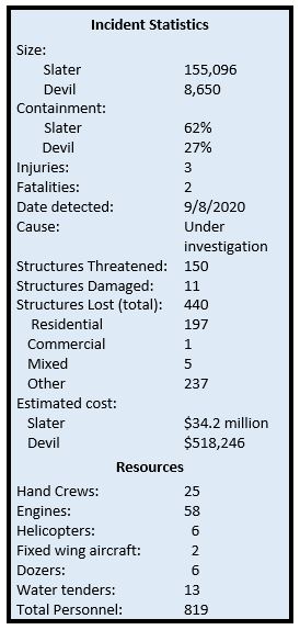
Slater Fire – 155,096 acres and 62% containment
The public can expect to see smoke from strategic firing operations, and fuels that continue to burn and smolder in the interior of the fire. Interior burning is expected to continue until season-ending weather occurs.
Crews are clearing hazard trees on steep slopes along both sides of the Grayback Road between Takilma and Happy Camp. This high-priority work is required to provide safe, reliable access for firefighters, residents, and those working to restore power to Happy Camp.
On the north and northwest flanks of the fire, from the California border north and east to Holland, crews are mopping up and extending the depth of containment line. On the northeast side of the fire, crews are working to build containment lines towards Swan Mountain. The east side of the fire is holding west of the Thompson Creek drainage.
Firefighters are also extending the depth of mop up and patrol efforts on the southern flank of the fire, while putting out smoldering stumps and hot spots within fire lines where needed.
On the southwest side of the fire, firefighters are looking for containment opportunities in the Sanger Peak area, while extending mop up and patrol work along Sanger Peak Road.
Both direct and indirect tactics are being used on the west side of the fire to prevent westward movement. Firefighters will continue to bring the fire down to containment lines in the Knopki Creek area east of Hwy 199.
Devil Fire - 8,650 acres and 27% containment
Mop up and patrol continue along the northern and southern areas of the fire, with lines holding along the Applegate River, 1040 Road, and Pacific Crest Trail. There is active fire in a snag patch to the east, but containment lines are holding. Crews will patrol the southwest flank, working on direct line into the Fort Goff Creek area.
Weather and Fire BehaviorTemperatures will be slightly warmer tomorrow, with a trend toward slightly lower humidity. Winds will be out of the northeast, switching to the west/northwest in the afternoon. Some increase of interior burning is expected, with smoke remaining on the western edge of the fire, reducing visibility.
Evacuations
Josephine County information: 541-474-5305 or www.facebook.com/josephinecountyEM, www.co.josephine.or.us/fire, or www.rvem.org
Siskiyou County information: (530) 841-2900 or www.facebook.com/SiskiyouCountySheriff/
Del Norte County information: (707) 464-7213 or www.facebook.com/DelNorteOfficeOfEmergencyServices and www.preparedelnorte.com/
Closures: The USDA Forest Service-Pacific Southwest Region’s Order, that closed some national forests in California, has been lifted for the Six Rivers and Klamath National Forests; however, new fire area closure orders have been issued by these forests for the Slater Fire area in California. The region is under emergency fire restrictions, although the use of gas stoves is now allowed in open developed recreation sites. Find updated closure orders and maps at: www.fs.usda.gov/klamath and www.fs.usda.gov/srnf.
Portions of both the Rogue River-Siskiyou National Forest’s Wild Rivers Ranger District and Siskiyou Mountains Ranger District reopened for use. Some areas remain closed for emergency crews’ safety and to allow for fire suppression and burned area recovery. Find updated closure orders and maps at: www.fs.usda.gov/alerts/rogue-siskiyou/alerts-notices.
The Bureau of Land Management Medford District has public lands closures in effect near the Slater Fire and South Obenchain Fire. Closure area maps are available at: www.blm.gov/programs/public-safety-and-fire/fire-and-aviation/regional-info/oregon-washington/fire-restrictions.
 Printable version of today's update can be found here
Printable version of today's map can be found here

Slater and Devil Fires Update
Sunday, October 4, 2020; 9:00 a.m.
South Zone (530) 324-2528North Zone (503) 867-8593Facebook @SlaterandDevilFireInformation or @KlamathNF or @SixRiversNF or @R6RRSNF Smoke information: https://wildlandfiresmoke.net/outlooksInciWeb: inciweb.nwcg.gov/incident/7173/
Slater Fire - 155,004 acres and 55% containment
On the north and northwest flanks of the fire from the California border north and east to Holland, crews continue to mop up and extend the depth of containment line. On the northeast side of the fire, crews are working on constructing fire lines towards Swan Mountain. Air support is available and will be utilized when smoky conditions decrease.
The east side of the fire is holding on the west side of the Thompson Creek drainage.
Firefighters are also extending the depth of mop up and patrol efforts on the southern side of the fire area, and are putting out smoldering stumps and hot spots within fire lines where needed.
On the southwest part of the fire, firefighters are looking for containment opportunities in the Sanger Peak area, while also extending mop up and patrol efforts along Sanger Peak Road.
Both direct and indirect tactics are being used on the west side of the fire to prevent westward movement. Firefighters will continue to bring the fire down to containment lines in the Knopki Creek area east of Hwy 199.
The public will continue to see smoke from strategic firing operations and fuels that continue to burn and smolder in the interior of the fire. Crews are also clearing hazard trees on steep slopes along both sides of Grayback Road (Happy Camp Highway) between Takilma and Happy Camp.
Devil Fire - 8,531 acres and 25% containment
Mop up and patrol continue along the northern and southern areas of the fire, with lines holding along the Applegate River, 1040 Road, and Pacific Crest Trail. There is active fire in a snag patch to the east, but containment lines are holding. Crews will continue to patrol the southwest flank and work on direct line into the Fort Goff Creek area.
Weather and Fire Behavior
Temperatures will be slightly cooler today, with a trend toward slightly higher humidities. Winds will be out of the northeast, switching to the west/northwest in the afternoon. Isolated pockets of interior fuels continue to burn, with smoke remaining on the western edge of the fire, reducing visibility.
Josephine County information: 541-474-5305 or www.facebook.com/josephinecountyEM, www.co.josephine.or.us/fire, or www.rvem.org
Siskiyou County information: (530) 841-2900 or www.facebook.com/SiskiyouCountySheriff/
Del Norte County information: (707) 464-7213 or www.facebook.com/DelNorteOfficeOfEmergencyServices and www.preparedelnorte.com/
Closures: The USDA Forest Service-Pacific Southwest Region’s Order, that closed some national forests in California, has been lifted for the Six Rivers and Klamath National Forests; however, new fire area closure orders have been issued by these forests for the Slater Fire area in California. The region is under emergency fire restrictions, although the use of gas stoves is now allowed in open developed recreation sites. Find updated closure orders and maps at: www.fs.usda.gov/klamath and www.fs.usda.gov/srnf.
Portions of both the Rogue River-Siskiyou National Forest’s Wild Rivers Ranger District and Siskiyou Mountains Ranger District reopened for use. Some areas remain closed for emergency crews’ safety and to allow for fire suppression and burned area recovery. Find updated closure orders and maps at: www.fs.usda.gov/alerts/rogue-siskiyou/alerts-notices.
The Bureau of Land Management Medford District has public lands closures in effect near the Slater Fire and the South Obenchain Fire. Closure area maps are available at: www.blm.gov/programs/public-safety-and-fire/fire-and-aviation/regional-info/oregon-washington/fire-restrictions.


Printable version of today's update can be found here
Printable version of today's map can be found here 
Update - Slater and Devil Fires
October 3, 2020, 8:00 a.m.
South Zone Slater/Devil Fire Info: (530) 324-2528; 8:00 a.m. – 8:00 p.m.
North Zone Slater Fire Info: (503) 867-8593; 8:00 a.m. – 8:00 p.m.
General Fire Info - Wildland Info Center: (458) 206-3043; 8:00 a.m. – 8:00 p.m.
Media Information: (541) 249-5117; 8:00 a.m. – 8:00 p.m.
Email: Slaterfirenorth.information@gmail.com
Website: inciweb.nwcg.gov/incident/7173/
Facebook: www.facebook.com/SlaterAndDevilFireInformation
Northwest Incident Management Team 7 assumed command of both fires this morning at 6:00 a.m. With moderate temperatures and humidity expected, crews will continue efforts to hold and secure fire lines.
Slater Fire – 154,814 acres and 51% containment
On the northwest flank, south of O’Brien, the fire is in patrol status and containment lines remain strong. Firefighters are pulling hose and equipment from the area and reallocating resources to other branches as needed. At Althouse Creek, crews are mopping up and patrolling along containment lines to check fire spread to the north. Crews will continue to hold and secure the fire near the Sucker Creek and Left Fork of Sucker Creek drainages, and seek opportunities to extend fire line along Swan Ridge.
To the east, firefighters continue with direct line construction and road prep above Thompson Creek heading north through Mill Creek. Crews are reinforcing containment lines and seeking opportunities to extend both direct and indirect fire line.
On the southern side of the fire area, containment lines are holding and crews continue to mop up and patrol in Happy Camp and along the southwest flank up to Kelly Lake.
On the west side of the fire, crews continue to utilize both direct and indirect attack to prevent westward movement of the fire. Firefighters will continue to bring the fire down to containment lines in the Knopki Creek area east of Hwy 199. Crews continue to extinguish hot spots north of Sanger Lake, and seek opportunities to build direct line.
In the interior of the fire, hazard tree removal will continue along State Route 96 that accesses Happy Camp with additional resources arriving. Steep slopes are present on both sides of the highway in this area, and firefighters will be on the lookout for hazards. Air support is available and will be utilized when smoky conditions decrease.
Devil Fire – 8,598 acres and 21% containment
Mop up and patrol continue along the north and south sides of the fire, with lines holding along the Applegate River, 1040 Road, and Pacific Crest Trail. There is active fire in a snag patch to the east, but containment lines are holding. Crews will continue to patrol the southwest flank and work on direct line into the Fort Goff Creek area.
Weather
Seasonally warm and dry conditions will continue across the fire today, but there will be a trend toward slightly higher humidity especially across the western portions with a little stronger onshore flow. Temperatures will be in the 70s and 80s with afternoon relative humidity reaching 25% to 35%.
Evacuations
Josephine County information: 541-474-5305 or www.facebook.com/josephinecountyEM, www.co.josephine.or.us/fire, or www.rvem.org
Siskiyou County information: (530) 841-2900 or www.facebook.com/SiskiyouCountySheriff/
Del Norte County information: (707) 464-7213 or www.facebook.com/DelNorteOfficeOfEmergencyServices and www.preparedelnorte.com/
Closures
The USDA Forest Service-Pacific Southwest Region’s Order, that closed some national forests in California, has been lifted for the Six Rivers and Klamath National Forests; however, new fire area closure orders have been issued by these forests for the Slater Fire area in California. The region is still under emergency fire restrictions, although the use of gas stoves is now allowed in open developed recreation sites. Find updated closure orders and maps at: www.fs.usda.gov/klamath and www.fs.usda.gov/srnf.
Portions of both the Rogue River-Siskiyou National Forest’s Wild Rivers Ranger District and Siskiyou Mountains Ranger District reopened for use. Some areas remain closed for emergency crews’ safety and to allow for fire suppression and burned area recovery. Find updated closure orders and maps at: www.fs.usda.gov/alerts/roguesiskiyou/alerts-notices.
The Bureau of Land Management Medford District has public lands closures in effect near the Slater Fire and South Obenchain Fire. Closure area maps are available at: www.blm.gov/programs/public-safety-and-fire/fireand-aviation/regional-info/oregon-washington/fire-restrictions.


Printable version of today's update can be found here
Printable version of today's map can be found here 
Slater and Devil Fires Update
Friday, October 2, 2020 7:30 a.m.
Fire origin: September 8, 2020
South Zone Slater/Devil Fire Info (530) 324-2528; 8 a.m. – 8 p.m.
North Zone Slater Fire Info (503) 867-8593; 8 a.m. – 8 p.m.
General Fire Info - Wildland Info Center: (458) 206-3043; 8 a.m. – 8 p.m.
Media Information: (541) 249-5117; 8 a.m. – 8 p.m.
Email: Slaterfirenorth.information@gmail.com
Website: inciweb.nwcg.gov/incident/7173/
Facebook: www.facebook.com/SlaterAndDevilFireInformation
Summary:
Containment lines are continuing to hold on the Slater and Devil fires, and firefighters will continue patrol and mop-up efforts. As a collective, personnel dedicated to the fire are averaging 20,000 hours a day. The Slater Fire is now 50% contained, and the Devil Fire remains at 20%. The final nightshift concluded at midnight on Friday morning. The Northern Rockies National Incident Management Team Two will be transitioning out, and the Northwest Incident Management Team 7 will assume command as of 6:00 Saturday morning.
The majority of containment lines on the Slater Fire are holding up well, and mop-up efforts will continue into Friday. On the east side, line in the Thompson Creek area remains strong, and progress will continue to be made into the weekend.
The south end of the fire will remain in patrol status. Fire lines have been holding in these areas over the past couple of days, and confidence is high that containment lines will remain strong.
On Thursday, firefighters were able to access a road on the west side of the fire, where access has previously been limited. With these new road systems, crews will be able to make significant progress on Friday in the interior, north of Idlewild. Fire lines in this area continue to hold strong.
On the northern flank, south of O’Brien, the fire is in patrol status and lines remain strong. Firefighters will begin to pull hose and equipment from this area to reallocate to other branches that are in need of resources.
To the east, hand line is holding near the 18 Road, and containment in this area is expected by Friday evening. Crews will also watch the Deadman’s Gulch area and work to secure lines. Preventative measures to protect Oregon Caves National Monument will conclude on Friday as well.
In the interior of the fire, operations will continue on Grayback Road, and additional resources will be put in place. Steep slopes are present in this area, and firefighters will be on the lookout for any hazard trees. Air support is available and will be utilized if smoky conditions decrease.
Devil Fire: Containment lines on the Devil Fire are holding well, and fire activity is minimal. The west side has reached an area outside the Goff Fire Scar at the Red Butte Wilderness Valley, while the east flank has been holding on the ridgeline above the Pacific Crest Trail.
Weather: Relatively dry and smoky conditions are expected. A ridge of high pressure we’ve been under will shift east and allow onshore flow into the area to bring northwest winds to the ridgetops. Temperatures are predicted to be slightly cooler on Friday.
Evacuations
There have been some evacuation changes; please refer to your local county’s Sheriff’s Office for details. County Sheriffs continue to work with fire leadership to determine when to modify evacuation levels.
Josephine County information: 541-474-5305 or www.facebook.com/josephinecountyEM, www.co.josephine.or.us/fire, or www.rvem.org
Siskiyou County information: (530) 841-2900 or www.facebook.com/SiskiyouCountySheriff/
Del Norte County information: (707) 464-7213 or www.facebook.com/DelNorteOfficeOfEmergencyServices and www.preparedelnorte.com/
Closures: The USDA Forest Service-Pacific Southwest Region’s Order, that closed some national forests in California, has been lifted for the Six Rivers and Klamath national forests; however, new fire area closure orders have been issued by these forests for the Slater Fire in California. The region is under emergency fire restrictions, although the use of gas stoves is now allowed.
Portions of both the Rogue River-Siskiyou National Forest’s Wild Rivers Ranger District and Siskiyou Mountains Ranger District reopened for use. Some areas remain closed for emergency crews’ safety and to allow for fire suppression and burned area recovery. Find updated closure orders and maps at: www.fs.usda.gov/alerts/rogue-siskiyou/alerts-notices
The Bureau of Land Management Medford District has public lands closures in effect near the Slater Fire and the South Obenchain Fire. Closure area maps are available at: www.blm.gov/programs/public-safety-and-fire/fire-and-aviation/regional-info/oregon-washington/fire-restrictions


Slater and Devil Fires UpdateThursday, October 1, 2020 7:30 a.m.
Fire origin: September 8, 2020South Zone Slater/Devil Fire Info (530) 324-2528; 8 a.m. – 8 p.m.North Zone Slater Fire Info (503) 867-8593; 8 a.m. – 8 p.m.General Fire Info - Wildland Info Center: (458) 206-3043; 8 a.m. – 8 p.m.Media Information: (541) 249-5117; 8 a.m. – 8 p.m.Website: inciweb.nwcg.gov/incident/7173/
SummaryCrews are continuing to make good progress on the fire line, focusing on mop-up efforts around Happy Camp and securing line from Highway 199 into the Illinois Valley. Hot, dry and smoky weather is expected to persist, with smoke drifting up from numerous fires in Northern California.
Slater Fire: Crews are working to connect more than 240 miles of fire line around the perimeter of the Slater fire. Firefighters will be continuing mop-up and patrols in the areas around Happy Camp in the south and the Illinois Valley to the north. Lines are holding well in these areas, and crews will be doing repair work for the communities in the area.
Hot spots have been challenging firefighters on the western and eastern flanks, and both areas could see increased fire activity in the next couple of days, as hot and dry weather is predicted. Hot spots have been detected along both sides, and crews will be working to put in line and strengthen existing ones. Mop-up efforts will continue near Idlewild. On the east side, rough terrain has been an added challenge for crews.
With smoky conditions, aircraft has not been an available resource. Ground crews are working along Greyback Road in the interior of the fire to mitigate hazardous trees and will continue this work into Thursday.
Mop-up efforts are progressing near Browntown to the north, as crews work to connect lines with the east side. Progress on contingency hand lines to protect the Oregon Caves National Monument will continue as well.
Poison oak has been reported, and one firefighter has been treated. Safety is a top priority among crews, and firefighters will be monitored for any signs of fatigue.
Devil Fire: Firefighters are concentrating on the southwestern edge of the Devil fire. Mop-up, patrol, and work securing the fire’s edge will continue.
Weather: Very low relative humidity and above normal temperatures will continue through the week. Winds will remain light. Winds in high terrain could reach up to 20 mph later in the week, with the potential to increase fire activity.
EvacuationsThere have been some evacuation changes; please refer to your local county’s Sheriff’s Office for details. County Sheriffs continue to work with fire leadership to determine when to modify evacuation levels.
Josephine County information: 541-474-5305 or www.facebook.com/josephinecountyEM, www.co.josephine.or.us/fire, or www.rvem.org
Siskiyou County information: (530) 841-2900 or www.facebook.com/SiskiyouCountySheriff/
Del Norte County information: (707) 464-7213 or www.facebook.com/DelNorteOfficeOfEmergencyServices and www.preparedelnorte.com/ Closures: The USDA Forest Service-Pacific Southwest Region’s Order, that closed some national forests in California, has been lifted for the Six Rivers and Klamath national forests; however, new fire area closure orders have been issued by these forests for the Slater Fire in California. The region is under emergency fire restrictions, although the use of gas stoves is now allowed.
Portions of both the Rogue River-Siskiyou National Forest’s Wild Rivers Ranger District and Siskiyou Mountains Ranger District reopened for use. Some areas remain closed for emergency crews’ safety and to allow for fire suppression and burned area recovery. Find updated closure orders and maps at: www.fs.usda.gov/alerts/rogue-siskiyou/alerts-notices
The Bureau of Land Management Medford District has public lands closures in effect near the Slater Fire and the South Obenchain Fire. Closure area maps are available at: www.blm.gov/programs/public-safety-and-fire/fire-and-aviation/regional-info/oregon-washington/fire-restrictions


Slater and Devil Fires Update
Wednesday, September 30, 2020, 7:30 a.m.
Fire origin: September 8, 2020South Zone Slater/Devil Fire Info (530) 324-2528; 8 a.m. – 8 p.m.North Zone Slater Fire Info (503) 867-8593; 8 a.m. – 8 p.m.General Fire Info - Wildland Info Center: (458) 206-3043; 8 a.m. – 8 p.m.Media Information: (541) 249-5117; 8 a.m. – 8 p.m.Website: inciweb.nwcg.gov/incident/7173/
SummaryThe fire line continues to hold well with minimal movement and growth observed. Winds will continue to blow smoke into the area from large active fires to the south in California. Fire officials remind the public to use extra caution due to the extreme fire conditions
Slater Fire: In both the north and south, the primary work for firefighters is mop-up, patrol, and securing the fire’s edge as fuels continue to dry. Crews will continue to monitor and build containment line from the Oregon/California border on the west side of Highway 199 east to the Sucker Creek area. Firefighters are using direct and indirect attacks to tie in the slop-overs west of Hwy 199. The contingency line at Oregon Caves National Monument is nearly complete. Crews continue to work down the left fork of Sucker Creek and around Swan Mountain, building firelines along the northeast perimeter and down the east flank.
The area north of Sanger Lake is being scouted for possible direct firelines. Firefighters are mopping up and holding Knopki Creek as well as areas south of Holland Loop along Althouse Creek Rd. Crews are also tying in and securing firelines from Hwy 199 into the Illinois Valley along the northwest flank of the fire.
In the Elk Creek drainage and Browntown area, crews continue to go direct and construct containment line as close to the fire as they can. Over the next several days, small firing operations may be used to clean up fuels between the main body of the fire and the constructed fire line in the Monkey Creek Ridge area, the area south of Browntown to Number Eight Gulch, and along the east side of the fire.
Crews in the Happy Camp area continued to patrol and mop-up along the fire line. Work is focused on mop-up and patrol of containment lines around Happy Camp, along Hwy 96, and along the southwest perimeter of the fire. Direct line construction and road prep is continuing above Thompson Creek on the east side, moving north to meet the crews moving south from Sucker Creek and Swan Mountain. Crews are working from both the north and the south on hazard tree mitigations along Grayback Rd.
Devil Fire: Aerial water drops were used along the north edge of the fire to help with hotspots. Firefighters continue to mop-up, patrol, and secure the fire’s edge. Contingency lines are in place. The south edge of the fire has containment line from the Pacific Crest Trail towards Fort Goff Creek.
Weather: High temperatures and low relative humidity will continue through the week. Winds will remain light while temperatures persist in the 90s through the week. As fuels become available across the fire area, flanking, backing, and potential interior torching may be observed.
EvacuationsThere have been some evacuation changes, please refer to your local county’s Sheriff’s Office for details. County Sheriffs continue to work with fire leadership to determine when to modify evacuation levels.
Josephine County information: 541-474-5305 or www.facebook.com/josephinecountyEM, www.co.josephine.or.us/fire, or www.rvem.org
Siskiyou County information: (530) 841-2900 or www.facebook.com/SiskiyouCountySheriff/
Del Norte County information: (707) 464-7213 or www.facebook.com/DelNorteOfficeOfEmergencyServices and www.preparedelnorte.com/ Closures: The USDA Forest Service Pacific Southwest Region extended the Regional Order through September 30, 2020, temporarily closing nine national forests, including the Six Rivers and Klamath National Forests. The region is under emergency fire restrictions.
Portions of both the Rogue River-Siskiyou National Forest’s Wild Rivers Ranger District and Siskiyou Mountains Ranger District reopened for use. Some areas remain closed for emergency crews’ safety and to allow for fire suppression and burned area recovery. Find updated closure orders and maps at: www.fs.usda.gov/alerts/rogue-siskiyou/alerts-notices
The Bureau of Land Management Medford District has public lands closures in effect near the Slater Fire and the South Obenchain Fire. Closure area maps are available at: www.blm.gov/programs/public-safety-and-fire/fire-and-aviation/regional-info/oregon-washington/fire-restrictions


Slater and Devil Fires Update
Tuesday, September 29, 2020, 7:30 a.m.
Fire origin: September 8, 2020South Zone Slater/Devil Fire Info (530) 324-2528; 8 a.m. – 8 p.m.North Zone Slater Fire Info (503) 867-8593; 8 a.m. – 8 p.m.General Fire Info - Wildland Info Center: (458) 206-3043; 8 a.m. – 8 p.m.Media Information: (541) 249-5117; 8 a.m. – 8 p.m.Website: inciweb.nwcg.gov/incident/7173/
SummaryThe Red Flag Warning ended yesterday at 8 p.m. The fire line held very well with no movement or growth reported. With the high temperatures yesterday and forecasted through the rest of the week, fuels will continue to dry out. Fire officials remind the public to use extra caution due to the extreme fire conditions. Winds out of the south will blow smoke into the fire area today.
Public MeetingNorthern Rockies Team 2 Incident Management Team will hold a virtual public meeting tonight at 6 p.m. The meeting will be live streamed to help minimize the spread of COVID-19. Fire managers and representatives from the community will provide an update on the fire situation, evacuations and closures, and county services. The meeting will be on Facebook at: www.facebook.com/SlaterAndDevilFireInformation
Slater Fire: Crews will continue to hold and improve the line from the Oregon/California border on the west side of Highway 199 east to the Sucker Creek area. . Mop-up and direct line construction continue on the north end of the fire and crews continue to make great progress as increased humidity and natural barriers have slowed fire activity. In both the north and south, the primary work for firefighters is mop-up and patrolling to evaluate the fire edge as fuels continue to dry. The fire line continues to hold while interior pockets of unburned fuels will ignite as fuels dry.
Crews continue to dig control lines and make great progress as moisture from the recent rains and natural barriers have slowed the fire.
Today, Oregon State Fire Marshal's Office and remaining structural firefighting task forces demobilized. Completion of structural protection coincided with decreased evacuation levels in Josephine County. Structural firefighters deployed to the Slater Fire protected and triaged over 2,700 structures.
Devil Fire: Even with the Red Flag Warning yesterday, fire lookouts reported very little smoke from the Devil fire. Crews have made good progress on the fire and lines held along the fire edge. Firefighters continue to build line along the southwest side. Crews will continue mopping up hotspots, improving the line, and patrolling the fire’s edge. The south edge of the fire has been contained from the Pacific Crest Trail towards Fort Goff Creek.
Weather: Temperatures in the valley are expected to be in the 90s this week although winds will become lighter. Relative humidity is expected to remain relatively low with very poor recovery through the night, creating conditions where any new fire start could spread rapidly. As fuels become available across the fire area, flanking, backing, and potential interior torching may be observed.
EvacuationsThere was one change in evacuation levels for Josephine County yesterday. Multiple levels of evacuations remain across the fire area. County Sheriffs continue to work with fire leadership to determine when to modify evacuation levels.
Josephine County information: 541-474-5305 or www.facebook.com/josephinecountyEM, www.co.josephine.or.us/fire, or www.rvem.org
Siskiyou County information: (530) 841-2900 or www.facebook.com/SiskiyouCountySheriff/
Del Norte County information: (707) 464-7213 or www.facebook.com/DelNorteOfficeOfEmergencyServices and www.preparedelnorte.com/ Closures: The USDA Forest Service Pacific Southwest Region extended the Regional Order through September 30, 2020, temporarily closing nine national forests, including the Six Rivers and Klamath National Forests. The region is under emergency fire restrictions.
Parts of both the Wild Rivers Ranger District and Siskiyou Mountains Ranger District reopened. Some areas remain closed for emergency crews’ safety and to allow for fire suppression and burned area recovery. Find updated closure orders and maps at: www.fs.usda.gov/alerts/rogue-siskiyou/alerts-notices
The Bureau of Land Management Medford District has public lands closures in effect near the Slater Fire and the South Obenchain Fire. Closure area maps are available at: www.blm.gov/programs/public-safety-and-fire/fire-and-aviation/regional-info/oregon-washington/fire-restrictions


Printable version of today's update can be found herePrintable version of today's map can be found here 
Slater and Devil Fires Update
Monday, September 28, 2020, 7:30 a.m.
Fire origin: September 8, 2020South Zone Slater/Devil Fire Info (530) 324-2528; 8 a.m. – 8 p.m.North Zone Slater Fire Info (503) 867-8593; 8 a.m. – 8 p.m.General Fire Info - Wildland Info Center: (458) 206-3043; 8 a.m. – 8 p.m.Media Information: (541) 249-5117; 8 a.m. – 8 p.m.Email: Slaterfirenorth.information@gmail.comWebsite: inciweb.nwcg.gov/incident/7173/
SummaryHigh ridgetop winds grounded most aircraft yesterday. Late afternoon, helicopters supported firefighters, dropping water from buckets in the Thompson Creek area and flying reconnaissance missions. UAS (drones) also flew portions of the fire to identify hotspots. Fire officials want to remind the public to use extreme caution when out recreating due to predicted high winds, temperatures, low relative humidity and very dry fuels, creating conditions for any new fire starts to spread rapidly.
Public MeetingNorthern Rockies Team 2 and the Oregon State Fire Marshal’s Blue Incident Management Team will hold a virtual public meeting at 6 p.m. PST, Tuesday, September 29, 2020. The meeting will be livestreamed to help meet recommendations for minimizing the spread of COVID-19. Members of the incident management teams and representatives for the local community will provide an update on the current wildfire situation, the status of evacuations and closures, and county services. The meeting will be live streamed on Facebook at: https://www.facebook.com/SlaterAndDevilFireInformation
Slater Fire: Crews will continue to hold and improve the line from the Oregon/California border on the west side of Highway 199 east to the Sucker Creek area. The primary direction for firefighters is mopup and patrol. Crews are finding fewer hotspots each day. Many areas have hose lay to bring water to the line and assist crews with mopup. The areas near communities such as Sun Star and Takilma are in final patrol status and the remaining out-of-state structural resources will start to head home on Tuesday.
Crews will look for opportunities over the next several days to complete small firing operations to clean up fuels between the main body of the fire and the constructed fireline in the Monkey Creek Ridge area, the area south of Browntown to Number Eight Gulch, and along the east side of the fire. Crews will continue to remove hazard trees from the roadside along the Grayback Road.
Crews in the Happy Camp area spent the day mopping up hotspots that were well inside the fire’s perimeter. Operations reported very few issues. The Thompson Creek area had debris rolling outside the fireline, causing a 1/3-acre spot that was caught quickly. Crews will continue digging line as close to the fire as they can and use small firing operations where necessary to clean up the fireline. Firefighters continue to construct direct fire line and prepare roads above Thompson Creek. Ariel ignition is planned to establish indirect sections of containment line above Thompson Creek. Crews continue treating hazard trees along Grayback Road.
Devil Fire: Crews on the Devil Fire have made good progress on the southeast side of the fire and lines held along the Butte Fork Trail, the 1040 Road and on the southwest corner of the fire. Firefighters continue to build line along the southwest side and are mopping up hotspots and cleaning up the line as they go. The south edge of the fire has been cold trailed from the Pacific Crest Trail towards Fort Goff Creek.
Weather: A Red Flag Warning remains in effect through Monday evening for high winds and low relative humidity. Temperatures in the valley are expected to be in the 90’s this week and relative humidity is expected to remain in the teens, creating conditions where any new fire start could spread rapidly.
EvacuationsThere were no changes in evacuation levels yesterday. County Sheriffs continue to work with fire leadership to determine when to modify evacuation levels.
Josephine County information: 541-474-5305 or www.facebook.com/josephinecountyEM, www.co.josephine.or.us/fire, or www.rvem.org
Siskiyou County information: (530) 841-2900 or www.facebook.com/SiskiyouCountySheriff/
Del Norte County information: (707) 464-7213 or www.facebook.com/DelNorteOfficeOfEmergencyServices and www.preparedelnorte.com/ Closures: The USDA Forest Service Pacific Southwest Region extended the Regional Order through September 30, 2020, temporarily closing nine national forests, including the Six Rivers and Klamath National Forests. The region is under emergency fire restrictions.
Effective yesterday, parts of both the Wild Rivers Ranger District and Siskiyou Mountains Ranger District reopened. Some areas remain closed for emergency crews’ safety and to allow for fire suppression and burned area recovery. Find updated closure orders and maps at: https://www.fs.usda.gov/alerts/rogue-siskiyou/alerts-notices
The Bureau of Land Management Medford District has public lands closures in effect near the Slater Fire and the South Obenchain Fire. Closure area maps are available at: www.blm.gov/programs/public-safety-and-fire/fire-and-aviation/regional-info/oregon-washington/fire-restrictions


 Slater and Devil Fires Update
Sunday, September 27, 2020, 7:30 a.m.
Fire origin: September 8, 2020South Zone Slater/Devil Fire Info (530) 324-2528; 8 a.m. – 8 p.m.North Zone Slater Fire Info (503) 867-8593; 8 a.m. – 8 p.m.General Fire Info - Wildland Info Center: (458) 206-3043; 8 a.m. – 8 p.m.Media Information: (541) 249-5117; 8 a.m. – 8 p.m.Email: Slaterfirenorth.information@gmail.comWebsite: inciweb.nwcg.gov/incident/7173/
SummaryThe Josephine County Sheriff’s office removed and reduced some evacuation levels, described below. The little rain the area received has not reduced the fire danger. A hot front is moving into the area, with expected high winds. This weather will likely increase fire activity. Fuels remain very dry. Patrols are still finding abandoned illegal campfires. Campfires are illegal right now. Slater Fire: Crews have completed their work closer to Gasquet, so those crews moved to the southside of the fire on Highway 199. South of O’Brien, crews are mopping up and will be connecting more lines in the coming days. More firefighters and engines moved to the northernmost part of the fire, south of Holland, to continue mopping up. Crews are digging line directly along the fires edge near Browntown. Firefighters continue widening control lines around the fire to protect communities, forests, and other resources.
Devil Fire: Crews on the Devil fire have made good progress on the southeast side of the fire and are continuing to build line along the southwest side. Weather: A Red Flag Warning is in effect from Sunday night through Monday evening. The hot, dry weather will move in Sunday and persist through the week. Winds from 10-20 mph and gusts to 30 are expected to increase fire activity.
EvacuationsJosephine County Sheriff’s Office removed the Level 1 evacuation order for the area and roads connected to the following – north of Caves Highway from the west end of Holland Loop Road to Grayback Road; U.S. Highway 199 between mileposts 34 and 37; Lone Mountain Road; O’Brien Road; and Waldo Road from U.S. Highway 199 to 900 Waldo Road. Lowered from Level 2 to Level 1: the area on Highway 199 between mileposts 34 to 38.5 including connecting county roads; Waldo Road from 900 Waldo Road to 3200 Waldo Road; Wood Creek Road from Waldo Road to Shepherd Hill Road; Rockdale Road and connecting roads; Holland Loop Road from Caves Highway to Hayes Cut-Off Road; Holland Loop Road from 8000 Holland Loop Road to Caves Highway; White House School Road and connecting roads. Lowered from Level 3 to Level 2: the area on U.S. Highway 199 between milepost 38.5 and the Oregon state line; residents at 34975, 34987, 34095, 35053, 35055 Redwood Highway; Shepherd Hill Road; Waldo Road between 3200 Waldo Road to Takilma Road; Takilma Road and connecting roads from Holland Loop Road to the Oregon state line; Happy Camp Road and connecting roads to the forest boundary; Dick George Road and connecting roads from Takilma Road to Holland Loop Road; Holland Loop Road and connecting county roads between Hayes Cut-Off Road and 8000 Holland Loop Road. Remaining at Level 3: The mining claims and residents located beyond the intersection of beebee Drive and Althouse Creek Road.
Josephine County information: 541-474-5305 or www.facebook.com/josephinecountyEM, www.co.josephine.or.us/fire, or www.rvem.org
Siskiyou County information: (530) 841-2900 or www.facebook.com/SiskiyouCountySheriff/
Del Norte County information: (707) 464-7213 or www.facebook.com/DelNorteOfficeOfEmergencyServices and www.preparedelnorte.com/ Closures: The USDA Forest Service Pacific Southwest Region extended the Regional Order through September 30, 2020, temporarily closing nine national forests, including the Six Rivers and Klamath National Forests. The region is under emergency fire restrictions.
Effective yesterday, parts of both the Wild Rivers Ranger District and Siskiyou Mountains Ranger District on the Rogue River Siskiyou National Forest reopened. Some areas remain closed for emergency crews’ safety and to allow for fire suppression and burned area recovery. Find updated closure orders and maps at: https://www.fs.usda.gov/alerts/rogue-siskiyou/alerts-notices
The Bureau of Land Management Medford District rescinded public lands closure notices across much of the District. Public lands closures remain in effect near the Slater Fire. Closure area maps are available at: www.blm.gov/programs/public-safety-and-fire/fire-and-aviation/regional-info/oregon-washington/fire-restrictions


Slater and Devil Fires UpdateSaturday, September 26, 2020, 7:30 a.m.
Fire origin: September 8, 2020
South Zone Slater/Devil Fire Info (530) 324-2528; 8 a.m. – 8 p.m.
North Zone Slater Fire Info (503) 867-8593; 8 a.m. – 8 p.m.
General Fire Info - Wildland Info Center: (458) 206-3043; 8 a.m. – 8 p.m. Media Information: (541) 249-5117; 8 a.m. – 8 p.m.
North Zone Email: Slaterfirenorth.information@gmail.com
South Zone Email: 2020.Slater@firenet.gov
Website: inciweb.nwcg.gov/incident/7173/
Summary
Fire personnel took advantage of the recent moderating weather conditions to focus on mopping up, improving existing lines, conducting strategic firing operations and constructing line around the perimeter of the fire. Critical fire weather conditions are expected to develop over the weekend and interior fire activity is expected to increase. Creeping and smoldering activity will likely transition to more visible flames and fire behavior.Slater Fire
Firefighters continue to focus on reducing the wildfire threat to nearby communities and strengthening the control lines around the perimeter of the fire. Structure task forces remain working around communities, monitoring impacted residences and ensuring there are no concerns.
North Zone: Firefighters continue mop up and patrol along the western side of the North Zone. Direct and indirect methods will be used to tie in fire areas that had crossed to the western side of Highway 199. Firing and blacklining will proceed in the Knopki Creek area (east of Highway 199), areas west of Highway 199 and the areas South of Holland Loop along Althouse Creek Road.
South Zone: Direct line construction and road prepping will continue above Thompson Creek and aerial ignitions will be utilized for strategic firing areas on the southeast side of the fire.
Devil Fire: The south edge of the fire has been patrolled, inspected and mopped up from Pacific Crest Trail west, towards Fort Goff Creek. Crews continue to utilize both direct and indirect lines along the north and east sides of the fire. Contingency lines are in place.
Weather: An upper level ridge will bring a rapid warming and drying trend starting today and persisting into early next week. Critical fire weather conditions are expected for Sunday and Monday. The relative humidity will begin to gradually drop today and then drop more drastically Sunday and remain low into Monday. A hot and dry weather pattern is expected for Tuesday through Thursday.
EvacuationsJosephine County Sheriff’s Office is lifting the evacuation status for all residents located on the following road systems including secondary roads: Hwy 199 from mileposts 25 to 34 including connecting county roads, the City of Cave Junction, Rockydale Road from US Hwy 199 to Pinecone Drive, Caves Highway from Cave Junction to the west end of Holland Loop Road. The Sheriff is also downgrading the evacuation level from a Level 2 “Be Set” to a Level 1 “Be Ready” for all residents living on the north side of Caves Highway from the west end of Holland Loop Road to Grayback Road are included in this downgrade. In addition, the evacuation level was downgraded from Level 3 “Go” to Level 2 “Be Set for residents located along US Highway 199 from milepost 37 to the Oregon State line. This includes Elk Creek Road and Dwight Creek Road; Takilma Road from 7000 block to 10000 block Takilma Road, including connecting county roads in that area; and Happy Camp Road including connecting county roads to milepost 3.
All other evacuation levels remain the same. For more information, visit the Josephine County Sheriff’s Office website.Evacuation information is available at 541-474-5305 (11 a.m. – 3 p.m.) or: www.facebook.com/josephinecountyEM, www.co.josephine.or.us/fire, or www.rvem.org.Siskiyou County evacuation information is available at (530) 841-2900 or online at: www.facebook.com/SiskiyouCountySheriff/
Del Norte County evacuation information is available at (707) 464-7213 or online at:www.facebook.com/DelNorteOfficeOfEmergencyServices and www.preparedelnorte.com/
The small amount of precipitation has not significantly reduced the fire danger. All fuels remain at critically dry levels. Patrols are still finding illegal abandoned campfires. All recreation visitors are reminded campfires are illegal at this time.
Closures: The USDA Forest Service Pacific Southwest Region has extended the Regional Order temporarily closing nine national forests in California, including the Six Rivers and Klamath National Forests. This decision will continue to be reviewed daily with changing fire and weather. The entire region is also under emergency fire restrictions.
Effective yesterday, portions of both the Wild Rivers Ranger District and Siskiyou Mountains Ranger District have reopened for public entry. Some public land areas remain closed to reduce interference with emergency crews and allow for fire suppression and burned area recovery. Find updated closure orders and maps at: https://www.fs.usda.gov/alerts/rogue-siskiyou/alerts-notices
The Bureau of Land Management Medford District has rescinded public lands closure notices across much of the District. Public lands closures remain in effect near the Slater Fire and the South Obenchain Fire. Maps of the closure areas are available on the Bureau of Land Management's website: www.blm.gov/programs/public-safety-and-fire/fire-and- aviation/regional-info/oregon-washington/fire-restrictions


Printable version to today's update can be found herePrintable version of today's map can be found here
###
Slater and Devil Fires UpdateFriday, September 25, 2020, 7:30 a.m.
Fire origin: September 8, 2020
South Zone Slater/Devil Fire Info (530) 324-2528; 8 a.m. – 8 p.m.
North Zone Slater Fire Info (503) 867-8593; 8 a.m. – 8 p.m.
General Fire Info - Wildland Info Center: (458) 206-3043; 8 a.m. – 8 p.m. Media Information: (541) 249-5117; 8 a.m. – 8 p.m.
North Zone Email: Slaterfirenorth.information@gmail.com
South Zone Email: 2020.Slater@firenet.gov
Website: inciweb.nwcg.gov/incident/7173/
Facebook: www.facebook.com/SlaterAndDevilFireInformation
Summary
Fire behavior analysts hiked several portions of the fire today and used drone flights to evaluate current fire behavior. With the recent precipitation, fire behavior decreased, and many areas are only showing a few smokes. Efforts will focus on mopping up, improving existing line and constructing line along the east and west flanks of the fire. Burnout operations were put on hold to allow damp fuels an extra day to dry out. Four additional crews, including the Rogue River Hotshots, and 15 engines will arrive on the fire tomorrow.
Slater Fire
North Zone: Firefighters continue to make progress on the north side of the fire from Highway 199 near Goodwish Creek Road to Browntown and many areas are moving into patrol status. Engines with the structure task forces will continue to work in and around the communities, monitoring impacted residences and ensuring there are no concerns.
Crews are building containment line along the southwest side of the fire from Knopki Creek to Sanger Lake. As weather conditions allow, crews will burnout to remove flammable material near the line. Line building continues along existing trails from the southeast corner of the Oregon Caves Monument toward the Sucker Creek area. Scouts are working to identify line location for the eastern side of the fire, and the best method to tie in the lines from the Monument to the line being built up from Thompson Creek.
Firefighters are focusing on two challenging locations: Monkey Ridge Road and the Lower Eight Gulch area southeast of Browntown. Both locations had several spotfires during Wednesday’s wind event. Firefighters were able to contain the spots and are continuing to construct line in preparation for small burnout operations to clean up unburned fuel.
South Zone: Mop up continues the community of Happy Camp. Crews will continue with line construction north of Thompson Creek. When conditions allow, crews will complete burnout operations to remove unburned fuel between indirect containment lines and the main fire.
Devil Fire
The Devil Fire received no precipitation yesterday; however, relative humidity was high enough to cause a decrease in fire behavior. Firefighters are holding the fire south of the 1040 road and continuing to build containment line on the southwest side of the fire along Fort Goff Road.
Weather: A second, weaker cold front is expected to move across the fire today, bringing a small amount of rain and keeping temperatures cool. Winds in the short term are expected to remain light with gusts to 25 mph over the ridges. Relative humidity is predicted to be 100 percent in the morning and decreasing to about 50 percent throughout the day. On Saturday, a high-pressure ridge will start to build, bringing warmer days and lower humidity. The ridge will continue through the week, with Tuesday possibly bringing record high temperatures.
EvacuationsJosephine County Sheriff’s Office is lifting the evacuation status for all residents located on the following road systems including secondary roads: Hwy 199 from mileposts 25 to 34 including connecting county roads, the City of Cave Junction, Rockydale Road from US Hwy 199 to Pinecone Drive, Caves Highway from Cave Junction to the west end of Holland Loop Road. The Sheriff is also downgrading the evacuation level from a Level 2 “Be Set” to a Level 1 “Be Ready” for all residents living on the north side of Caves Highway from the west end of Holland Loop Road to Grayback Road are included in this downgrade. In addition, the evacuation level was downgraded from Level 3 “Go” to Level 2 “Be Set for residents located along US Highway 199 from milepost 37 to the Oregon State line. This includes Elk Creek Road and Dwight Creek Road; Takilma Road from 7000 block to 10000 block Takilma Road, including connecting county roads in that area; and Happy Camp Road including connecting county roads to milepost 3.
All other evacuation levels remain the same. For more information, visit the Josephine County Sheriff’s Office website. Evacuation information is available at 541-474-5305 (9 a.m. – 6 p.m.) or: www.facebook.com/josephinecountyEM,www.co.josephine.or.us/fire, or www.rvem.org.Siskiyou County evacuation information is available at (530) 841-2900 or online at: www.facebook.com/SiskiyouCountySheriff/
Del Norte County evacuation information is available at (707) 464-7213 or online at:www.facebook.com/DelNorteOfficeOfEmergencyServices and www.preparedelnorte.com/
The small amount of precipitation has not significantly reduced the fire danger. All fuels remain at critically dry levels. Patrols are still finding illegal abandoned campfires. All recreation visitors are reminded campfires are illegal at this time.
Closures: The USDA Forest Service Pacific Southwest Region has extended the Regional Order temporarily closing nine national forests in California, including the Six Rivers and Klamath National Forests. This decision will continue to be reviewed daily with changing fire and weather. The entire region is also under emergency fire restrictions.
Rogue River-Siskiyou National Forest has temporarily closed the Wild Rivers Range District and Siskiyou Mountains Ranger District. Find closure orders and maps at https://www.fs.usda.gov/alerts/rogue-siskiyou/alerts-notices
The Bureau of Land Management Medford District has rescinded public lands closure notices across much of the District. Public lands closures remain in effect near the Slater Fire and the South Obenchain Fire. Maps of the closure areas are available on the Bureau of Land Management's website: www.blm.gov/programs/public-safety-and-fire/fire-and- aviation/regional-info/oregon-washington/fire-restrictions

Printable PDF of today's update can be found here
###

Slater and Devil Fires Update
Thursday, September 24, 2020, 8:00 a.m.
Fire origin: September 8, 2020
South Zone Slater/Devil Fire Info (530) 324-2528; 8 a.m. – 8 p.m.
North Zone Slater Fire Info (503) 867-8593; 8 a.m. – 8 p.m.
General Fire Info - Wildland Info Center: (458) 206-3043; 8 a.m. – 8 p.m.
Media Information: (541) 249-5117; 8 a.m. – 8 p.m.
North Zone Email: Slaterfirenorth.information@gmail.com
South Zone Email: 2020.Slater@firenet.gov
Website: inciweb.nwcg.gov/incident/7173/
Facebook: www.facebook.com/SlaterAndDevilFireInformation
Summary
Winds throughout the valley were a good test for line along the west side of the fire. Isolated interior islands of fuel burned as they were exposed to gusty southwest winds. The Slater fire is 150,956 acres and 24 percent contained. The Devil fire is 7,784 acres and remains 18 percent contained. Firefighters continue to make good progress holding and improving containment lines on both fires. UAS (drones) were used for reconnaissance flights over the fire today to gather information for planning future operations. Cooler temperatures and rain showers are forecast for today.
Slater Fire
North Zone
Crews continue to hold and improve existing containment lines. They are working close to the fire line to keep the fire from growing. Operations today will focus on constructing line between Knopki Creek and Sanger Lake.
The fire came up to the dozer line near Monkey Creek Ridge and is holding. Helicopters assisted crews by dropping water on the fire until winds were too high.
Crews continue to hold and improve the fire line along Highway 199, as well as north and east toward the Browntown area. High afternoon winds caused a spot fire over the line in the Eight Spur Gulch area; however, crews caught it at 20 acres. On the northeast side of the fire near Oregon Caves National Monument crews worked raking out existing trails. The Sucker Creek area saw little new activity.
South Zone
Mop up continues in and around the communities of Happy Camp and Indian Creek. Crews will continue with direct line construction north of Thompson Creek. When conditions allow, crews will complete burnout operations to remove unburned fuel between indirect containment lines and the main fire. Fire progression to the southwest and west has slowed as the fire burns into the Natchez Fire scar.
Devil Fire: Crews on the southwest corner of the fire were able to tie handline down into the creek drainage. The fire remains south of the 1040 Road and is holding to the west of the Butte Fork Trail. An additional crew was assigned and working on the southwest edge of the fire.
Weather: Rain, cooler temperatures and higher relative humidity are forecast for today. Last night the Slater Fire received the following amounts of precipitation: .7 inches on the west side, .4 inches through the center and north, and .2 inches on the east. The Devil Fire received a trace of rain on the north and none on the south.
Evacuations
Josephine County evacuation levels remain the same. For more information, visit the Josephine County Sheriff’s Office website. Evacuation information is available at 541-474-5305 (8 a.m. – 8 p.m.) or: www.facebook.com/josephinecountyEM, www.co.josephine.or.us/fire, or www.rvem.org.
Siskiyou County evacuation information is available at (530) 841-2900 or online at: www.facebook.com/SiskiyouCountySheriff/.
Del Norte County evacuation information is available at (707) 464-7213 or online at: www.facebook.com/DelNorteOfficeOfEmergencyServices and
Closures: The USDA Forest Service Pacific Southwest Region has extended the Regional Order temporarily closing nine national forests in California, including the Six Rivers and Klamath (including the part in Oregon) National Forests. This decision will continue to be reviewed daily with changing fire and weather. The entire region is also under emergency fire restrictions.
Rogue River-Siskiyou National Forest has temporarily closed the Wild Rivers Range District and Siskiyou Mountains Ranger District. Find closure orders and maps at www.fs.usda/gov/alerts/rogue-siskiyou/alerts-notices.
The Bureau of Land Management Medford District temporarily closed many areas of public lands to support fire suppression efforts and to prevent new fire starts. Maps of the closure areas are available on the Bureau of Land Management's website: www.blm.gov/programs/public-safety-and-fire/fire-and-aviation/regional-info/oregon-washington/fire-restrictions.

Printable PDF of today's map is available here
###
 Slater and Devil Fires UpdateWednesday, September 23, 2020, 7:30 a.m.
Fire origin: September 8, 2020
South Zone Slater/Devil Fire Info (530) 324-2528; 8 a.m. – 8 p.m.
North Zone Slater Fire Info (503) 867-8593; 8 a.m. – 8 p.m.
General Fire Info - Wildland Info Center: (458) 206-3043; 8 a.m. – 8 p.m. Media Information: (541) 249-5117; 8 a.m. – 8 p.m.
North Zone Email: Slaterfirenorth.information@gmail.com
South Zone Email: 2020.Slater@firenet.gov
Website: inciweb.nwcg.gov/incident/7173/
Facebook: www.facebook.com/SlaterAndDevilFireInformation
Summary
The Slater fire is 150,230 acres and 24 percent contained. The Devil fire is 7,784 acres and remains 18 percent contained. Northern Rockies Incident Management Team 2 assumed command of the entire Slater and Devil Fires (north and south zones) at 6 p.m. yesterday. Firefighters continue to make good progress holding and improving containment lines on both fires and most of the growth on the fire is due to backing and creeping. Critical fire weather is expected today with winds out of the southwest at 25 miles per hour with gusts to 40.
Slater Fire
North Zone: Crews continue to hold and improve existing containment lines. They are constructing new line, working close to the fire line to keep the fire from growing. Firefighters are also preparing structures to protect those building from potential fire spread.
Hand crews and dozers have been working west of Highway 199 to construct indirect control lines along Monkey Ridge. The two sides are expected to tie together today. Several hot shot crews will be used to complete burnout operations to clean up any unburned fuel between the line and the main edge of the fire when conditions allow.
Crews are mopping up and still holding the line on the north side of the fire from Goodwish Creek near Hwy 199 east to the Sun Star area and back north. Firefighters are working on several hotspots along the line around Hope Mountain and will continue to reinforce the line up toward Horseshoe Gulch.
Crews successfully completed a burnout south of Holland and will begin mopping up that area. Firefighters are reinforcing the line around Browntown and toward Oregon Caves National Monument. Hand crews continue to reinforce the line south of Oregon Caves to protect the monument.
South Zone: Mop up continues in and around the communities of Happy Camp and Indian Creek. Crews will continue with direct line construction north of Thompson Creek. When conditions allow, crews will complete burnout operations to remove unburned fuel between indirect containment lines and the main fire.
Devil Fire: Crews held the Devil Fire south of the 1040 Road. They continue to construct more line and establish hoselays along the north side of the fire to assist with mop up. Additional resources have been assigned to the fire to help construct line down the east side of the fire to tie in with contained line along the south side. Firefighters are stationed behind residences in Seiad to defend the fire line.
Weather: Fire operations will use lookouts today due to expected winds that could increase fire behavior. Winds will be out of the southwest at 25 miles per hour with gusts up to 40 miles per hour. Rain is expected to move into the area Wednesday night, followed by several days of cooler temperature and higher relative humidity.
Evacuations
Josephine County Sheriff’s Office downgraded evacuations to Level 2 “Be Set” for all residents on Wood Creek Rd andShepherd Hill Rd and issued a downgrade in evacuations to a Level 1 “Be Ready” for all residents in the following area; US Hwy 199 from milepost 34 to 36.5 including all of Lone Mountain Rd and secondary roads, O’Brien Rd, O’Brien St, Primrose Ln, Udee Rd and Waldo Rd from US Hwy 199 to and including Big Springs Drive.
All other evacuation levels remain the same. For more information, visit the Josephine County Sheriff’s Office website.Evacuation information is available at 541-474-5305 (8 a.m. – 8 p.m.) or: www.facebook.com/josephinecountyEM,www.co.josephine.or.us/fire, or www.rvem.org.
Siskiyou County evacuation information is available at (530) 841-2900 or online at: www.facebook.com/SiskiyouCountySheriff/.
Del Norte County evacuation information is available at (707) 464-7213 or online at:www.facebook.com/DelNorteOfficeOfEmergencyServices and www.preparedelnorte.com/.
Closures: The USDA Forest Service Pacific Southwest Region has extended the Regional Order temporarily closing nine national forests in California, including the Six Rivers and Klamath (including the part in Oregon) National Forests. This decision will continue to be reviewed daily with changing fire and weather. The entire region is also under emergency fire restrictions.
Rogue River-Siskiyou National Forest has temporarily closed the Wild Rivers Range District and Siskiyou Mountains Ranger District. Find closure orders and maps at www.fs.usda/gov/alerts/rogue-siskiyou/alerts-notices.
The Bureau of Land Management Medford District temporarily closed many areas of public lands to support fire suppression efforts and to prevent new fire starts. Maps of the closure areas are available on the Bureau of Land Management's website: www.blm.gov/programs/public-safety-and-fire/fire-and-aviation/regional-info/oregon- washington/fire-restrictions.

Printable version of Today's Update available here
###
Slater and Devil Fires Update
Tuesday, September 22, 2020, 7:30 a.m.
Fire origin: September 8, 2020
South Zone Slater/Devil Fire Info (CA) (530) 324-2528; 8 a.m. – 8 p.m.
North Zone Slater Fire Info (OR) (503) 867-8593; 8 a.m. – 8 p.m.
General Fire Info - Wildland Info Center: (458) 206-3043; 8 a.m. – 8 p.m.
Media Information: (541) 249-5117; 8 a.m. – 8 p.m.
North Zone Email: Slaterfirenorth.information@gmail.com
South Zone Email: 2020.Slater@firenet.gov
Website: inciweb.nwcg.gov/incident/7173/
Facebook: www.facebook.com/SlaterAndDevilFireInformation
Summary
The Slater fire is 148,677 acres and 22 percent contained. The Devil fire is 7,458 acres and is 18 percent contained. The Josephine County Sheriff’s office reduced the Dick George Road evacuation level to Level 2 “Be Set.” Greenview Drive remains in evacuation Level 3 “Go” status.
Cave Junction remains at Level 1. For more information, visit the Josephine County Sheriff’s Office website.
Slater Fire
North Zone: Smoke was visible today as isolated interior areas of the fire burned as the inversion lifted and ridgetop winds blew. Crews are working as close to the fire as they can to keep the fire from growing. The fire's movement to the southwest and south has slowed as the fire burns into old fire scars.
Hand crews and dozers have been working west of Highway 199 to construct indirect control lines. Crews have almost completed the lines from Highway 199 along Monkey Ridge and back around the top of the fire to Highway 199.
Mop up activities are nearly complete on the northwest side of the fire. Night crews monitored the burn operations south of Holland to secure that edge of the fire. Firefighters are reinforcing indirect lines in the northeast section, south of Oregon Caves, to protect the monument.
South Zone: With a lot of black line along the south side of the fire in and around Happy Camp, crews continue to patrol and reassign equipment to other areas of the fire. Firefighters continue to mop up and monitor along Highway 96, while helping fire back down into the Thompson Creek drainage. Protection remains behind residences in Seiad for now and firefighters are stationed there to defend that line. Last night an infrared flight showed the fire’s footprint is 150,230 acres.
Devil Fire: The fire continues to burn mainly to the southwest. Winds could pick up to 15-20 miles per hour today coming from the southwest, with a chance that fire activity could increase. However, a small amount of rain is expected Wednesday night or Thursday. Last night an infrared flight showed the fire’s size is 7,784 acres.
Northern Rockies Incident Management Team 2 will assume command of the entire Slater and Devil Fires (north and south zones) at 6 p.m. today, as California Interagency Incident Management Team 10 transitions out.
Weather: Tomorrow winds from the southwest are expected to be 10-15 miles per hour with gusts up to 25.
Evacuations
Josephine County Sheriff’s Office reduced the Level 3 “Go” status of Dick George Road area to Level 2 “Be Set” for all residences located on the following road systems including secondary roads; Takilma Rd from Holland Loop Rd to 7050 Takilma Rd, Dick George Rd, River Grove, Beaver Meadow, Ridge Vista, Glory Ln, Lamont Way, Shadow Wood Dr, Jackadel Ln and Kirkham Rd. Greenview Drive remains in Level 3 “go” evacuation status. The Cave Junction area was reduced Level 1 “Be Ready.”
All other evacuation levels remain the same. For more information, visit the Josephine County Sheriff’s Office website.Evacuation information is available at 541-474-5305 (8 a.m. – 8 p.m.) or: www.facebook.com/josephinecountyEM,www.co.josephine.or.us/fire, or www.rvem.org
Siskiyou County evacuation information is at: www.facebook.com/SiskiyouCountySheriff/.
Del Norte County evacuation information is at: www.facebook.com/DelNorteOfficeOfEmergencyServices and www.preparedelnorte.com/
Closures: The USDA Forest Service Pacific Southwest Region has extended the Regional Order temporarily closing nine national forests in California, including the Six Rivers and Klamath (including the part in Oregon) National Forests. This decision will continue to be reviewed daily with changing fire and weather. The entire region is also under emergency fire restrictions.
Rogue River-Siskiyou National Forest has temporarily closed the Wild Rivers Range District and Siskiyou Mountains Ranger District. Find closure orders and maps at www.fs.usda/gov/alerts/rogue-siskiyou/alerts-notices
The Bureau of Land Management Medford District temporarily closed many areas of public lands to support fire suppression efforts and to prevent new fire starts. Maps of the closure areas are available on the Bureau of Land Management's website: www.blm.gov/programs/public-safety-and-fire/fire-and-aviation/regional-info/oregon- washington/fire-restrictions.


Wednesday, October 7, 2020; 9:00 a.m.
Fires always look closer and bigger in the dark! With the earlier evenings in Fall, more people are noticing and reporting flames from fuels that continue to burn and smolder within the interior of the fires. Firefighters expect this burning to continue until prolonged wet weather moves into the area. Residents are asked to familiarize themselves with the location of fire perimeters. Flames observed within them should not be reported. Fires outside of established containment lines should always be reported to 911 or local fire protection authorities.
Slater Fire – 155,510 acres and 67% containment
Little new growth has been observed on the fire since yesterday, however, minimal fire spread is expected to occur on the eastern flank. This area has been obscured by smoke and could not be visually monitored. On all flanks, the strategy is to strengthen containment lines where access permits, and monitor unlined portions of the fire for movement that could potentially expand the burned area.
On the north side of the fire, mop-up, patrol, and structure defense continue along containment lines, and firefighters are increasing the depth of containment. Crews have completed containment lines south of Browntown, including the Deadman’s Gulch area. The containment lines along Sucker Creek are secure and crews have extended hand line to Swan Mountain.
On the east side, the containment line up through Mill Creek is holding and direct line construction continues above Thompson Creek. Firefighters continue to monitor the area between Swan Mountain and Mill Creek.
On the south side, crews continue to patrol, monitor, and reinforce containment lines in Happy Camp and along the southwest side up to Kelly Lake. Firefighters are cleaning up spot fires as well as increasing the depth of containment.
The most active fire suppression efforts are underway in the southwest portion of the fire, in the Knopki and Chicago Creek drainages, where firefighters are working to keep it contained east of Chicago Creek. Additional crews have been assigned to the area. The trend toward cooler temperatures and higher humidity makes fire spread increasingly unlikely in that location.
Crews are felling hazard trees that are likely to fall onto the road from steep slopes along both sides of the Grayback Road (also known as Happy Camp Highway) between Takilma and Happy Camp. This high-priority work is required to provide safe, reliable access for firefighters, residents, and those working to restore power to Happy Camp. Additional emphasis is being placed on other roads needed for fire and suppression activities.
Devil Fire - 8,723 acres and 32% containment
A period of increasing humidity and decreasing temperatures begins today. Winds will be from the south to southeast in the morning, switching through the day to west-southwest. Inversions will trap smoke in the valleys in the morning, possibly lifting in the afternoon. Increasingly cooler and damper conditions are expected over the next several days, with precipitation expected Saturday afternoon.
Evacuations
Anyone interested in accessing their home or property should contact the local sheriff’s office.
Siskiyou County information: (530) 841-2900 or www.facebook.com/SiskiyouCountySheriff/
Del Norte County information: (707) 464-7213 or www.facebook.com/DelNorteOfficeOfEmergencyServices and www.preparedelnorte.com/
Closures
The Klamath, Six Rivers, and Rogue River-Siskiyou National Forests have issued fire area closure orders for the Slater and Devil Fires. The Pacific Southwest Region is under emergency fire restrictions, although the use of gas stoves is allowed in open developed recreation sites. Find closure orders and maps at: www.fs.usda.gov/klamath, www.fs.usda.gov/rogue-siskiyou, and www.fs.usda.gov/srnf.
Portions of both the Rogue River-Siskiyou National Forest’s Wild Rivers Ranger District and Siskiyou Mountains Ranger District have reopened for use. Some areas remain closed for emergency crews’ safety and to allow for fire suppression and burned area recovery. Find closure orders and maps at: www.fs.usda.gov/alerts/rogue-siskiyou/alerts-notices.
The Bureau of Land Management Medford District has public lands closures in effect near the Slater Fire and South Obenchain Fire. Find closure area maps at: www.blm.gov/programs/public-safety-and-fire/fire-and-aviation/regional-info/oregon-washington/fire-restrictions.


Tuesday, October 6, 2020; 9:00 a.m.
Forest management agencies and Northwest Incident Management Team 7 need your help! There have been reports of several near-miss vehicle accidents on roads around the fire, especially in the Holland Loop Road and Takilma areas. Please be patient. There are numerous fire vehicles on the road, increasing local traffic. Please drive defensively and remain mindful of the current situation. There are lots of moving parts and we want to keep all firefighters and residents safe. Thank you for your support.
Slater Fire – 155,287 acres and 65% containment
Most of the fire has remained within the same “footprint” for several days, with only minimal growth on the inaccessible eastern flank. On all perimeters, the strategy is to strengthen containment lines where access permits, and monitor unlined portions of the fire (primarily the eastern flank) for fire movement that could potentially expand the burned area. Smoky conditions have inhibited air operations, but ground crews are patrolling accessible areas and attacking hotspots where needed.
The most likely area to challenge firefighters in the days ahead is the southwest portion of the fire in the Knopki and Chicago Creek drainages, where firefighters are working to keep it contained east of Chicago Creek. Additional crews are being assigned to this area to strengthen containment lines against the incoming period of warmer, drier weather.
Crews are felling hazard trees that are likely to fall onto the road from steep slopes along both sides of the Grayback Road (also known as Happy Camp Highway) between Takilma and Happy Camp. This high-priority work is required to provide safe, reliable access for firefighters, residents, and those working to restore power to Happy Camp.
Devil Fire - 8,693 acres and 30% containment
Mop up and patrol continue along the northern and southern areas of the fire, with lines holding along the Butte Fork of the Applegate River, 1040 Road, and Pacific Crest Trail. Crews will patrol the southeast flank, building fire line into the Fort Goff Creek area. Firefighters must hike for several hours to reach the fire’s edge there.
On both the Devil and Slater Fires, the public can expect to see smoke from strategic firing operations, as well as fuels that continue to burn and smolder in the interior of the fire. Interior burning is expected to continue until a season-ending weather event occurs.
Weather and Fire Behavior
Today will mark the warmest and driest day of the week, with very low humidity. Winds will be from the east in the morning, switching to southwest, west and finally northwest in the afternoon. High pressure over the area is expected to create a smoke-trapping inversion. Smoke from fires to the south will likely accumulate in the valleys.
Evacuations
Anyone interested in accessing their home or property should contact the local sheriff’s office.
Siskiyou County information: (530) 841-2900 or www.facebook.com/SiskiyouCountySheriff/
Del Norte County information: (707) 464-7213 or www.facebook.com/DelNorteOfficeOfEmergencyServices and www.preparedelnorte.com/
Closures: The Klamath, Six Rivers, and Rogue River-Siskiyou National Forests have issued fire area closure orders in effect for the Slater and Devil Fires. The Pacific Southwest Region is under emergency fire restrictions, although the use of gas stoves is allowed in open developed recreation sites. Find updated closure orders and maps at: www.fs.usda.gov/klamath, www.fs.usda.gov/rogue-siskiyou, and www.fs.usda.gov/srnf.
Portions of both the Rogue River-Siskiyou National Forest’s Wild Rivers Ranger District and Siskiyou Mountains Ranger District have reopened for use. Some areas remain closed for emergency crews’ safety and to allow for fire suppression and burned area recovery. Find updated closure orders and maps at: www.fs.usda.gov/alerts/rogue-siskiyou/alerts-notices.
The Bureau of Land Management Medford District has public lands closures in effect near the Slater Fire and South Obenchain Fire. Find closure area maps at: www.blm.gov/programs/public-safety-and-fire/fire-and-aviation/regional-info/oregon-washington/fire-restrictions.


Slater and Devil Fires Update
Monday, October 5, 2020; 9:00 a.m.
Slater Fire – 155,096 acres and 62% containment
The public can expect to see smoke from strategic firing operations, and fuels that continue to burn and smolder in the interior of the fire. Interior burning is expected to continue until season-ending weather occurs.
Crews are clearing hazard trees on steep slopes along both sides of the Grayback Road between Takilma and Happy Camp. This high-priority work is required to provide safe, reliable access for firefighters, residents, and those working to restore power to Happy Camp.
On the north and northwest flanks of the fire, from the California border north and east to Holland, crews are mopping up and extending the depth of containment line. On the northeast side of the fire, crews are working to build containment lines towards Swan Mountain. The east side of the fire is holding west of the Thompson Creek drainage.
Firefighters are also extending the depth of mop up and patrol efforts on the southern flank of the fire, while putting out smoldering stumps and hot spots within fire lines where needed.
On the southwest side of the fire, firefighters are looking for containment opportunities in the Sanger Peak area, while extending mop up and patrol work along Sanger Peak Road.
Both direct and indirect tactics are being used on the west side of the fire to prevent westward movement. Firefighters will continue to bring the fire down to containment lines in the Knopki Creek area east of Hwy 199.
Devil Fire - 8,650 acres and 27% containment
Mop up and patrol continue along the northern and southern areas of the fire, with lines holding along the Applegate River, 1040 Road, and Pacific Crest Trail. There is active fire in a snag patch to the east, but containment lines are holding. Crews will patrol the southwest flank, working on direct line into the Fort Goff Creek area.
Weather and Fire BehaviorTemperatures will be slightly warmer tomorrow, with a trend toward slightly lower humidity. Winds will be out of the northeast, switching to the west/northwest in the afternoon. Some increase of interior burning is expected, with smoke remaining on the western edge of the fire, reducing visibility.
Evacuations
Josephine County information: 541-474-5305 or www.facebook.com/josephinecountyEM, www.co.josephine.or.us/fire, or www.rvem.org
Siskiyou County information: (530) 841-2900 or www.facebook.com/SiskiyouCountySheriff/
Del Norte County information: (707) 464-7213 or www.facebook.com/DelNorteOfficeOfEmergencyServices and www.preparedelnorte.com/
Closures: The USDA Forest Service-Pacific Southwest Region’s Order, that closed some national forests in California, has been lifted for the Six Rivers and Klamath National Forests; however, new fire area closure orders have been issued by these forests for the Slater Fire area in California. The region is under emergency fire restrictions, although the use of gas stoves is now allowed in open developed recreation sites. Find updated closure orders and maps at: www.fs.usda.gov/klamath and www.fs.usda.gov/srnf.
Portions of both the Rogue River-Siskiyou National Forest’s Wild Rivers Ranger District and Siskiyou Mountains Ranger District reopened for use. Some areas remain closed for emergency crews’ safety and to allow for fire suppression and burned area recovery. Find updated closure orders and maps at: www.fs.usda.gov/alerts/rogue-siskiyou/alerts-notices.
The Bureau of Land Management Medford District has public lands closures in effect near the Slater Fire and South Obenchain Fire. Closure area maps are available at: www.blm.gov/programs/public-safety-and-fire/fire-and-aviation/regional-info/oregon-washington/fire-restrictions.


Slater and Devil Fires Update
Sunday, October 4, 2020; 9:00 a.m.
Slater Fire - 155,004 acres and 55% containment
On the north and northwest flanks of the fire from the California border north and east to Holland, crews continue to mop up and extend the depth of containment line. On the northeast side of the fire, crews are working on constructing fire lines towards Swan Mountain. Air support is available and will be utilized when smoky conditions decrease.
The east side of the fire is holding on the west side of the Thompson Creek drainage.
Firefighters are also extending the depth of mop up and patrol efforts on the southern side of the fire area, and are putting out smoldering stumps and hot spots within fire lines where needed.
On the southwest part of the fire, firefighters are looking for containment opportunities in the Sanger Peak area, while also extending mop up and patrol efforts along Sanger Peak Road.
Both direct and indirect tactics are being used on the west side of the fire to prevent westward movement. Firefighters will continue to bring the fire down to containment lines in the Knopki Creek area east of Hwy 199.
The public will continue to see smoke from strategic firing operations and fuels that continue to burn and smolder in the interior of the fire. Crews are also clearing hazard trees on steep slopes along both sides of Grayback Road (Happy Camp Highway) between Takilma and Happy Camp.
Devil Fire - 8,531 acres and 25% containment
Mop up and patrol continue along the northern and southern areas of the fire, with lines holding along the Applegate River, 1040 Road, and Pacific Crest Trail. There is active fire in a snag patch to the east, but containment lines are holding. Crews will continue to patrol the southwest flank and work on direct line into the Fort Goff Creek area.
Weather and Fire Behavior
Temperatures will be slightly cooler today, with a trend toward slightly higher humidities. Winds will be out of the northeast, switching to the west/northwest in the afternoon. Isolated pockets of interior fuels continue to burn, with smoke remaining on the western edge of the fire, reducing visibility.
Josephine County information: 541-474-5305 or www.facebook.com/josephinecountyEM, www.co.josephine.or.us/fire, or www.rvem.org
Siskiyou County information: (530) 841-2900 or www.facebook.com/SiskiyouCountySheriff/
Del Norte County information: (707) 464-7213 or www.facebook.com/DelNorteOfficeOfEmergencyServices and www.preparedelnorte.com/
Closures: The USDA Forest Service-Pacific Southwest Region’s Order, that closed some national forests in California, has been lifted for the Six Rivers and Klamath National Forests; however, new fire area closure orders have been issued by these forests for the Slater Fire area in California. The region is under emergency fire restrictions, although the use of gas stoves is now allowed in open developed recreation sites. Find updated closure orders and maps at: www.fs.usda.gov/klamath and www.fs.usda.gov/srnf.
Portions of both the Rogue River-Siskiyou National Forest’s Wild Rivers Ranger District and Siskiyou Mountains Ranger District reopened for use. Some areas remain closed for emergency crews’ safety and to allow for fire suppression and burned area recovery. Find updated closure orders and maps at: www.fs.usda.gov/alerts/rogue-siskiyou/alerts-notices.
The Bureau of Land Management Medford District has public lands closures in effect near the Slater Fire and the South Obenchain Fire. Closure area maps are available at: www.blm.gov/programs/public-safety-and-fire/fire-and-aviation/regional-info/oregon-washington/fire-restrictions.


Update - Slater and Devil Fires
October 3, 2020, 8:00 a.m.
South Zone Slater/Devil Fire Info: (530) 324-2528; 8:00 a.m. – 8:00 p.m.
North Zone Slater Fire Info: (503) 867-8593; 8:00 a.m. – 8:00 p.m.
General Fire Info - Wildland Info Center: (458) 206-3043; 8:00 a.m. – 8:00 p.m.
Media Information: (541) 249-5117; 8:00 a.m. – 8:00 p.m.
Email: Slaterfirenorth.information@gmail.com
Website: inciweb.nwcg.gov/incident/7173/
Facebook: www.facebook.com/SlaterAndDevilFireInformation
Northwest Incident Management Team 7 assumed command of both fires this morning at 6:00 a.m. With moderate temperatures and humidity expected, crews will continue efforts to hold and secure fire lines.
Slater Fire – 154,814 acres and 51% containment
On the northwest flank, south of O’Brien, the fire is in patrol status and containment lines remain strong. Firefighters are pulling hose and equipment from the area and reallocating resources to other branches as needed. At Althouse Creek, crews are mopping up and patrolling along containment lines to check fire spread to the north. Crews will continue to hold and secure the fire near the Sucker Creek and Left Fork of Sucker Creek drainages, and seek opportunities to extend fire line along Swan Ridge.
To the east, firefighters continue with direct line construction and road prep above Thompson Creek heading north through Mill Creek. Crews are reinforcing containment lines and seeking opportunities to extend both direct and indirect fire line.
On the southern side of the fire area, containment lines are holding and crews continue to mop up and patrol in Happy Camp and along the southwest flank up to Kelly Lake.
On the west side of the fire, crews continue to utilize both direct and indirect attack to prevent westward movement of the fire. Firefighters will continue to bring the fire down to containment lines in the Knopki Creek area east of Hwy 199. Crews continue to extinguish hot spots north of Sanger Lake, and seek opportunities to build direct line.
In the interior of the fire, hazard tree removal will continue along State Route 96 that accesses Happy Camp with additional resources arriving. Steep slopes are present on both sides of the highway in this area, and firefighters will be on the lookout for hazards. Air support is available and will be utilized when smoky conditions decrease.
Devil Fire – 8,598 acres and 21% containment
Mop up and patrol continue along the north and south sides of the fire, with lines holding along the Applegate River, 1040 Road, and Pacific Crest Trail. There is active fire in a snag patch to the east, but containment lines are holding. Crews will continue to patrol the southwest flank and work on direct line into the Fort Goff Creek area.
Weather
Seasonally warm and dry conditions will continue across the fire today, but there will be a trend toward slightly higher humidity especially across the western portions with a little stronger onshore flow. Temperatures will be in the 70s and 80s with afternoon relative humidity reaching 25% to 35%.
Evacuations
Josephine County information: 541-474-5305 or www.facebook.com/josephinecountyEM, www.co.josephine.or.us/fire, or www.rvem.org
Siskiyou County information: (530) 841-2900 or www.facebook.com/SiskiyouCountySheriff/
Del Norte County information: (707) 464-7213 or www.facebook.com/DelNorteOfficeOfEmergencyServices and www.preparedelnorte.com/
Closures
The USDA Forest Service-Pacific Southwest Region’s Order, that closed some national forests in California, has been lifted for the Six Rivers and Klamath National Forests; however, new fire area closure orders have been issued by these forests for the Slater Fire area in California. The region is still under emergency fire restrictions, although the use of gas stoves is now allowed in open developed recreation sites. Find updated closure orders and maps at: www.fs.usda.gov/klamath and www.fs.usda.gov/srnf.
Portions of both the Rogue River-Siskiyou National Forest’s Wild Rivers Ranger District and Siskiyou Mountains Ranger District reopened for use. Some areas remain closed for emergency crews’ safety and to allow for fire suppression and burned area recovery. Find updated closure orders and maps at: www.fs.usda.gov/alerts/roguesiskiyou/alerts-notices.
The Bureau of Land Management Medford District has public lands closures in effect near the Slater Fire and South Obenchain Fire. Closure area maps are available at: www.blm.gov/programs/public-safety-and-fire/fireand-aviation/regional-info/oregon-washington/fire-restrictions.


Slater and Devil Fires Update
Friday, October 2, 2020 7:30 a.m.
Fire origin: September 8, 2020
South Zone Slater/Devil Fire Info (530) 324-2528; 8 a.m. – 8 p.m.
North Zone Slater Fire Info (503) 867-8593; 8 a.m. – 8 p.m.
General Fire Info - Wildland Info Center: (458) 206-3043; 8 a.m. – 8 p.m.
Media Information: (541) 249-5117; 8 a.m. – 8 p.m.
Email: Slaterfirenorth.information@gmail.com
Website: inciweb.nwcg.gov/incident/7173/
Facebook: www.facebook.com/SlaterAndDevilFireInformation
Containment lines are continuing to hold on the Slater and Devil fires, and firefighters will continue patrol and mop-up efforts. As a collective, personnel dedicated to the fire are averaging 20,000 hours a day. The Slater Fire is now 50% contained, and the Devil Fire remains at 20%. The final nightshift concluded at midnight on Friday morning. The Northern Rockies National Incident Management Team Two will be transitioning out, and the Northwest Incident Management Team 7 will assume command as of 6:00 Saturday morning.
The majority of containment lines on the Slater Fire are holding up well, and mop-up efforts will continue into Friday. On the east side, line in the Thompson Creek area remains strong, and progress will continue to be made into the weekend.
The south end of the fire will remain in patrol status. Fire lines have been holding in these areas over the past couple of days, and confidence is high that containment lines will remain strong.
On Thursday, firefighters were able to access a road on the west side of the fire, where access has previously been limited. With these new road systems, crews will be able to make significant progress on Friday in the interior, north of Idlewild. Fire lines in this area continue to hold strong.
On the northern flank, south of O’Brien, the fire is in patrol status and lines remain strong. Firefighters will begin to pull hose and equipment from this area to reallocate to other branches that are in need of resources.
To the east, hand line is holding near the 18 Road, and containment in this area is expected by Friday evening. Crews will also watch the Deadman’s Gulch area and work to secure lines. Preventative measures to protect Oregon Caves National Monument will conclude on Friday as well.
Weather: Relatively dry and smoky conditions are expected. A ridge of high pressure we’ve been under will shift east and allow onshore flow into the area to bring northwest winds to the ridgetops. Temperatures are predicted to be slightly cooler on Friday.
There have been some evacuation changes; please refer to your local county’s Sheriff’s Office for details. County Sheriffs continue to work with fire leadership to determine when to modify evacuation levels.
Josephine County information: 541-474-5305 or www.facebook.com/josephinecountyEM, www.co.josephine.or.us/fire, or www.rvem.org
Siskiyou County information: (530) 841-2900 or www.facebook.com/SiskiyouCountySheriff/
Del Norte County information: (707) 464-7213 or www.facebook.com/DelNorteOfficeOfEmergencyServices and www.preparedelnorte.com/
Closures: The USDA Forest Service-Pacific Southwest Region’s Order, that closed some national forests in California, has been lifted for the Six Rivers and Klamath national forests; however, new fire area closure orders have been issued by these forests for the Slater Fire in California. The region is under emergency fire restrictions, although the use of gas stoves is now allowed.
Portions of both the Rogue River-Siskiyou National Forest’s Wild Rivers Ranger District and Siskiyou Mountains Ranger District reopened for use. Some areas remain closed for emergency crews’ safety and to allow for fire suppression and burned area recovery. Find updated closure orders and maps at: www.fs.usda.gov/alerts/rogue-siskiyou/alerts-notices
The Bureau of Land Management Medford District has public lands closures in effect near the Slater Fire and the South Obenchain Fire. Closure area maps are available at: www.blm.gov/programs/public-safety-and-fire/fire-and-aviation/regional-info/oregon-washington/fire-restrictions


Thursday, October 1, 2020 7:30 a.m.


Slater and Devil Fires Update
Wednesday, September 30, 2020, 7:30 a.m.


Slater and Devil Fires Update
Tuesday, September 29, 2020, 7:30 a.m.


Slater and Devil Fires Update
Monday, September 28, 2020, 7:30 a.m.


Saturday, September 26, 2020, 7:30 a.m.
Summary
Slater Fire
Siskiyou County evacuation information is available at (530) 841-2900 or online at: www.facebook.com/SiskiyouCountySheriff/
The small amount of precipitation has not significantly reduced the fire danger. All fuels remain at critically dry levels. Patrols are still finding illegal abandoned campfires. All recreation visitors are reminded campfires are illegal at this time. Closures: The USDA Forest Service Pacific Southwest Region has extended the Regional Order temporarily closing nine national forests in California, including the Six Rivers and Klamath National Forests. This decision will continue to be reviewed daily with changing fire and weather. The entire region is also under emergency fire restrictions. Effective yesterday, portions of both the Wild Rivers Ranger District and Siskiyou Mountains Ranger District have reopened for public entry. Some public land areas remain closed to reduce interference with emergency crews and allow for fire suppression and burned area recovery. Find updated closure orders and maps at: https://www.fs.usda.gov/alerts/rogue-siskiyou/alerts-notices The Bureau of Land Management Medford District has rescinded public lands closure notices across much of the District. Public lands closures remain in effect near the Slater Fire and the South Obenchain Fire. Maps of the closure areas are available on the Bureau of Land Management's website: www.blm.gov/programs/public-safety-and-fire/fire-and- aviation/regional-info/oregon-washington/fire-restrictions Printable version of today's map can be found here ### |
Friday, September 25, 2020, 7:30 a.m.
Fire origin: September 8, 2020
South Zone Slater/Devil Fire Info (530) 324-2528; 8 a.m. – 8 p.m.
North Zone Slater Fire Info (503) 867-8593; 8 a.m. – 8 p.m.
General Fire Info - Wildland Info Center: (458) 206-3043; 8 a.m. – 8 p.m. Media Information: (541) 249-5117; 8 a.m. – 8 p.m.
North Zone Email: Slaterfirenorth.information@gmail.com
South Zone Email: 2020.Slater@firenet.gov
Website: inciweb.nwcg.gov/incident/7173/
Facebook: www.facebook.com/SlaterAndDevilFireInformation
Summary
Fire behavior analysts hiked several portions of the fire today and used drone flights to evaluate current fire behavior. With the recent precipitation, fire behavior decreased, and many areas are only showing a few smokes. Efforts will focus on mopping up, improving existing line and constructing line along the east and west flanks of the fire. Burnout operations were put on hold to allow damp fuels an extra day to dry out. Four additional crews, including the Rogue River Hotshots, and 15 engines will arrive on the fire tomorrow.
Slater Fire
Devil FireNorth Zone: Firefighters continue to make progress on the north side of the fire from Highway 199 near Goodwish Creek Road to Browntown and many areas are moving into patrol status. Engines with the structure task forces will continue to work in and around the communities, monitoring impacted residences and ensuring there are no concerns.
Crews are building containment line along the southwest side of the fire from Knopki Creek to Sanger Lake. As weather conditions allow, crews will burnout to remove flammable material near the line. Line building continues along existing trails from the southeast corner of the Oregon Caves Monument toward the Sucker Creek area. Scouts are working to identify line location for the eastern side of the fire, and the best method to tie in the lines from the Monument to the line being built up from Thompson Creek.
Firefighters are focusing on two challenging locations: Monkey Ridge Road and the Lower Eight Gulch area southeast of Browntown. Both locations had several spotfires during Wednesday’s wind event. Firefighters were able to contain the spots and are continuing to construct line in preparation for small burnout operations to clean up unburned fuel.
South Zone: Mop up continues the community of Happy Camp. Crews will continue with line construction north of Thompson Creek. When conditions allow, crews will complete burnout operations to remove unburned fuel between indirect containment lines and the main fire.
The Devil Fire received no precipitation yesterday; however, relative humidity was high enough to cause a decrease in fire behavior. Firefighters are holding the fire south of the 1040 road and continuing to build containment line on the southwest side of the fire along Fort Goff Road.
Weather: A second, weaker cold front is expected to move across the fire today, bringing a small amount of rain and keeping temperatures cool. Winds in the short term are expected to remain light with gusts to 25 mph over the ridges. Relative humidity is predicted to be 100 percent in the morning and decreasing to about 50 percent throughout the day. On Saturday, a high-pressure ridge will start to build, bringing warmer days and lower humidity. The ridge will continue through the week, with Tuesday possibly bringing record high temperatures.
Siskiyou County evacuation information is available at (530) 841-2900 or online at: www.facebook.com/SiskiyouCountySheriff/
Del Norte County evacuation information is available at (707) 464-7213 or online at:www.facebook.com/DelNorteOfficeOfEmergencyServices and www.preparedelnorte.com/The small amount of precipitation has not significantly reduced the fire danger. All fuels remain at critically dry levels. Patrols are still finding illegal abandoned campfires. All recreation visitors are reminded campfires are illegal at this time.
Closures: The USDA Forest Service Pacific Southwest Region has extended the Regional Order temporarily closing nine national forests in California, including the Six Rivers and Klamath National Forests. This decision will continue to be reviewed daily with changing fire and weather. The entire region is also under emergency fire restrictions.
Rogue River-Siskiyou National Forest has temporarily closed the Wild Rivers Range District and Siskiyou Mountains Ranger District. Find closure orders and maps at https://www.fs.usda.gov/alerts/rogue-siskiyou/alerts-notices
The Bureau of Land Management Medford District has rescinded public lands closure notices across much of the District. Public lands closures remain in effect near the Slater Fire and the South Obenchain Fire. Maps of the closure areas are available on the Bureau of Land Management's website: www.blm.gov/programs/public-safety-and-fire/fire-and- aviation/regional-info/oregon-washington/fire-restrictions
Slater and Devil Fires Update
Thursday, September 24, 2020, 8:00 a.m.
Fire origin: September 8, 2020
South Zone Slater/Devil Fire Info (530) 324-2528; 8 a.m. – 8 p.m.
North Zone Slater Fire Info (503) 867-8593; 8 a.m. – 8 p.m.
General Fire Info - Wildland Info Center: (458) 206-3043; 8 a.m. – 8 p.m.
Media Information: (541) 249-5117; 8 a.m. – 8 p.m.
North Zone Email: Slaterfirenorth.information@gmail.com
South Zone Email: 2020.Slater@firenet.gov
Website: inciweb.nwcg.gov/incident/7173/
Facebook: www.facebook.com/SlaterAndDevilFireInformation
Summary
Winds throughout the valley were a good test for line along the west side of the fire. Isolated interior islands of fuel burned as they were exposed to gusty southwest winds. The Slater fire is 150,956 acres and 24 percent contained. The Devil fire is 7,784 acres and remains 18 percent contained. Firefighters continue to make good progress holding and improving containment lines on both fires. UAS (drones) were used for reconnaissance flights over the fire today to gather information for planning future operations. Cooler temperatures and rain showers are forecast for today.
Slater Fire
North Zone
Crews continue to hold and improve existing containment lines. They are working close to the fire line to keep the fire from growing. Operations today will focus on constructing line between Knopki Creek and Sanger Lake.
The fire came up to the dozer line near Monkey Creek Ridge and is holding. Helicopters assisted crews by dropping water on the fire until winds were too high.
Crews continue to hold and improve the fire line along Highway 199, as well as north and east toward the Browntown area. High afternoon winds caused a spot fire over the line in the Eight Spur Gulch area; however, crews caught it at 20 acres. On the northeast side of the fire near Oregon Caves National Monument crews worked raking out existing trails. The Sucker Creek area saw little new activity.
South Zone
Mop up continues in and around the communities of Happy Camp and Indian Creek. Crews will continue with direct line construction north of Thompson Creek. When conditions allow, crews will complete burnout operations to remove unburned fuel between indirect containment lines and the main fire. Fire progression to the southwest and west has slowed as the fire burns into the Natchez Fire scar.
Devil Fire: Crews on the southwest corner of the fire were able to tie handline down into the creek drainage. The fire remains south of the 1040 Road and is holding to the west of the Butte Fork Trail. An additional crew was assigned and working on the southwest edge of the fire.
Weather: Rain, cooler temperatures and higher relative humidity are forecast for today. Last night the Slater Fire received the following amounts of precipitation: .7 inches on the west side, .4 inches through the center and north, and .2 inches on the east. The Devil Fire received a trace of rain on the north and none on the south.
Evacuations
Josephine County evacuation levels remain the same. For more information, visit the Josephine County Sheriff’s Office website. Evacuation information is available at 541-474-5305 (8 a.m. – 8 p.m.) or: www.facebook.com/josephinecountyEM, www.co.josephine.or.us/fire, or www.rvem.org.
Siskiyou County evacuation information is available at (530) 841-2900 or online at: www.facebook.com/SiskiyouCountySheriff/.
Del Norte County evacuation information is available at (707) 464-7213 or online at: www.facebook.com/DelNorteOfficeOfEmergencyServices and
Closures: The USDA Forest Service Pacific Southwest Region has extended the Regional Order temporarily closing nine national forests in California, including the Six Rivers and Klamath (including the part in Oregon) National Forests. This decision will continue to be reviewed daily with changing fire and weather. The entire region is also under emergency fire restrictions.
Rogue River-Siskiyou National Forest has temporarily closed the Wild Rivers Range District and Siskiyou Mountains Ranger District. Find closure orders and maps at www.fs.usda/gov/alerts/rogue-siskiyou/alerts-notices.
The Bureau of Land Management Medford District temporarily closed many areas of public lands to support fire suppression efforts and to prevent new fire starts. Maps of the closure areas are available on the Bureau of Land Management's website: www.blm.gov/programs/public-safety-and-fire/fire-and-aviation/regional-info/oregon-washington/fire-restrictions.
Fire origin: September 8, 2020
South Zone Slater/Devil Fire Info (530) 324-2528; 8 a.m. – 8 p.m.
North Zone Slater Fire Info (503) 867-8593; 8 a.m. – 8 p.m.
General Fire Info - Wildland Info Center: (458) 206-3043; 8 a.m. – 8 p.m. Media Information: (541) 249-5117; 8 a.m. – 8 p.m.
North Zone Email: Slaterfirenorth.information@gmail.com
South Zone Email: 2020.Slater@firenet.gov
Website: inciweb.nwcg.gov/incident/7173/
Facebook: www.facebook.com/SlaterAndDevilFireInformation
The Slater fire is 150,230 acres and 24 percent contained. The Devil fire is 7,784 acres and remains 18 percent contained. Northern Rockies Incident Management Team 2 assumed command of the entire Slater and Devil Fires (north and south zones) at 6 p.m. yesterday. Firefighters continue to make good progress holding and improving containment lines on both fires and most of the growth on the fire is due to backing and creeping. Critical fire weather is expected today with winds out of the southwest at 25 miles per hour with gusts to 40.
North Zone: Crews continue to hold and improve existing containment lines. They are constructing new line, working close to the fire line to keep the fire from growing. Firefighters are also preparing structures to protect those building from potential fire spread.
All other evacuation levels remain the same. For more information, visit the Josephine County Sheriff’s Office website.Evacuation information is available at 541-474-5305 (8 a.m. – 8 p.m.) or: www.facebook.com/josephinecountyEM,www.co.josephine.or.us/fire, or www.rvem.org.
Closures: The USDA Forest Service Pacific Southwest Region has extended the Regional Order temporarily closing nine national forests in California, including the Six Rivers and Klamath (including the part in Oregon) National Forests. This decision will continue to be reviewed daily with changing fire and weather. The entire region is also under emergency fire restrictions.
Tuesday, September 22, 2020, 7:30 a.m.
Fire origin: September 8, 2020
South Zone Slater/Devil Fire Info (CA) (530) 324-2528; 8 a.m. – 8 p.m.
North Zone Slater Fire Info (OR) (503) 867-8593; 8 a.m. – 8 p.m.
General Fire Info - Wildland Info Center: (458) 206-3043; 8 a.m. – 8 p.m.
Media Information: (541) 249-5117; 8 a.m. – 8 p.m.
North Zone Email: Slaterfirenorth.information@gmail.com
South Zone Email: 2020.Slater@firenet.gov
Website: inciweb.nwcg.gov/incident/7173/
Facebook: www.facebook.com/SlaterAndDevilFireInformation
Summary
The Slater fire is 148,677 acres and 22 percent contained. The Devil fire is 7,458 acres and is 18 percent contained. The Josephine County Sheriff’s office reduced the Dick George Road evacuation level to Level 2 “Be Set.” Greenview Drive remains in evacuation Level 3 “Go” status.
Cave Junction remains at Level 1. For more information, visit the Josephine County Sheriff’s Office website.
Slater Fire
North Zone: Smoke was visible today as isolated interior areas of the fire burned as the inversion lifted and ridgetop winds blew. Crews are working as close to the fire as they can to keep the fire from growing. The fire's movement to the southwest and south has slowed as the fire burns into old fire scars.
Hand crews and dozers have been working west of Highway 199 to construct indirect control lines. Crews have almost completed the lines from Highway 199 along Monkey Ridge and back around the top of the fire to Highway 199.
Mop up activities are nearly complete on the northwest side of the fire. Night crews monitored the burn operations south of Holland to secure that edge of the fire. Firefighters are reinforcing indirect lines in the northeast section, south of Oregon Caves, to protect the monument.
South Zone: With a lot of black line along the south side of the fire in and around Happy Camp, crews continue to patrol and reassign equipment to other areas of the fire. Firefighters continue to mop up and monitor along Highway 96, while helping fire back down into the Thompson Creek drainage. Protection remains behind residences in Seiad for now and firefighters are stationed there to defend that line. Last night an infrared flight showed the fire’s footprint is 150,230 acres.
Devil Fire: The fire continues to burn mainly to the southwest. Winds could pick up to 15-20 miles per hour today coming from the southwest, with a chance that fire activity could increase. However, a small amount of rain is expected Wednesday night or Thursday. Last night an infrared flight showed the fire’s size is 7,784 acres.
Northern Rockies Incident Management Team 2 will assume command of the entire Slater and Devil Fires (north and south zones) at 6 p.m. today, as California Interagency Incident Management Team 10 transitions out.
Weather: Tomorrow winds from the southwest are expected to be 10-15 miles per hour with gusts up to 25.
Evacuations
Josephine County Sheriff’s Office reduced the Level 3 “Go” status of Dick George Road area to Level 2 “Be Set” for all residences located on the following road systems including secondary roads; Takilma Rd from Holland Loop Rd to 7050 Takilma Rd, Dick George Rd, River Grove, Beaver Meadow, Ridge Vista, Glory Ln, Lamont Way, Shadow Wood Dr, Jackadel Ln and Kirkham Rd. Greenview Drive remains in Level 3 “go” evacuation status. The Cave Junction area was reduced Level 1 “Be Ready.”
All other evacuation levels remain the same. For more information, visit the Josephine County Sheriff’s Office website.Evacuation information is available at 541-474-5305 (8 a.m. – 8 p.m.) or: www.facebook.com/josephinecountyEM,www.co.josephine.or.us/fire, or www.rvem.org
Siskiyou County evacuation information is at: www.facebook.com/SiskiyouCountySheriff/.
Del Norte County evacuation information is at: www.facebook.com/DelNorteOfficeOfEmergencyServices and www.preparedelnorte.com/
Closures: The USDA Forest Service Pacific Southwest Region has extended the Regional Order temporarily closing nine national forests in California, including the Six Rivers and Klamath (including the part in Oregon) National Forests. This decision will continue to be reviewed daily with changing fire and weather. The entire region is also under emergency fire restrictions.
Rogue River-Siskiyou National Forest has temporarily closed the Wild Rivers Range District and Siskiyou Mountains Ranger District. Find closure orders and maps at www.fs.usda/gov/alerts/rogue-siskiyou/alerts-notices
The Bureau of Land Management Medford District temporarily closed many areas of public lands to support fire suppression efforts and to prevent new fire starts. Maps of the closure areas are available on the Bureau of Land Management's website: www.blm.gov/programs/public-safety-and-fire/fire-and-aviation/regional-info/oregon- washington/fire-restrictions.


Slater and Devil Fires UpdateSunday, September 20, 2020; 9:00 AM
Fire origin: September 7 ,2020
Fire Information: (530) 324-2528 Hours: 8am – 8pm
Media Information: (541) 249-5117 Hours: 8am – 8pm
Email: Slaterfirenorth.information@gmail.com
Websites: Inciweb: inciweb.nwcg.gov/incident/7173/
Facebook: Klamath National Forest Facebook Page, Six Rivers National Forest Facebook Page, Rogue River-Siskiyou National Forest Facebook Page
www.facebook.com/SlaterAndDevilFireInformation
Summary:
Slater Fire:
North Zone: Yesterday, additional scouting was performed to identify opportunities to secure the edge of the fire in the Talkilma area. For today, warmer temperatures and lower humidity will cause fuels to dry out and an increase in wind blowing toward the north and northwest can be expected. Resources will be conducting direct fire suppression activities on the north to northwest perimeter of the fire. Crews continue developing strategies to minimize the footprint of the fire’s edge, especially focusing in the northern perimeter of the fire to protect property at risk. Smoke may become more visible as crews perform burnout operations to consume unburned fuel between the fire line and the fire’s edge. To secure the western side of the fire, dozers will be used to establish indirect fire line. Yesterday Hwy 199 was reopened to through traffic in both California and Oregon. Firefighters are still working near the highway and motorists should expect delays of up to 20 minutes.
Firefighting efforts in the South Zone of the Slater Fire today will be focused on clearing hazard trees up the Grayback Road and attempting ignition (dependent on conditions) to contain the fire along the Thompson Creek Road and north along the Slater Fire’s edge. Firefighters continue to monitor the Devil Fire as it backs into the Goff Creek drainage. The structures near both Goff Creek and Thompson Creek are well protected, and fire behavior in the drainages continues to be fairly minimal. Crews have secured the south and east sides of the Devil Fire. Crews placed fire hose along the line they built behind residences on Seiad Creek Road as a contingency line. Highway 96 is now open with no restrictions, but motorists are advised to drive slowly as firefighters and equipment are still working off of the highway. Yesterday, northerly winds blew smoke across the Slater Fire area, settling it back into the Happy Camp area. Winds are expected to shift to the southeast today, which should help with air quality. The Slater Fire is now estimated at 146,698 acres and 18 % contained.
In the Gasquet (California) portion of the Slater Fire, firefighters held the fire at the Knopki Rd to protect the town of Gasquet. They will work to complete operations to secure the fire edge at the intersection of Hwy 199 and Knopki Rd. Structure protection activity continues from Knopki Rd to the town of Gasquet. South Zone
Devil Fire: Resources are engaging the fire as it wants to spread toward Applegate Lake moves in a northeast
direction. The southeast side of the Devil Fire is now lined and secure, with the crews using the Pacific Crest Trail as a containment line on the east. The Devil Fire is still generating some heat along its west side and southwest corner, but the Tahoe Hotshots were able to find the cold edge of that fire and build direct line to cut off its southward progress and herd it towards Fort Goff Creek, away from homes in and around Seiad Valley and Hwy 96. The Grayback Rd is still closed
to the public for hazard tree removal and power pole repair. The Devil Fire has one Type 2 initial attack crew, is currently at 7,144 acres and is 18% contained.
Weather: Winds are forecasted to be WNW at 6 with gusts up to 12mph. humidity in the midafternoon will be around 20% with warm seasonal weather with temperatures in the high 70’s continuing into Monday.
Evacuations:
Josephine County Sheriff’s Office reduced the following Level 3 “GO” Evacuation Zone to a Level 2 “BE SET” status: the area along US Hwy 199 from Gene Brown Rd to 37265 Redwood Hwy with US Hwy 199 has been reopened to through traffic. This includes Gene Brown Rd, Arrowhead Dr, and Leuizenger Ck/NF-9938 Rd. Addresses greater than 37265 Redwood Hwy will remain in a Level 3 “GO” evacuation status. As a reminder, if weather or fire behavior changes, the evacuation level could be raised to Level 3 “GO.”
Evacuation order/warning info and other resources for Josephine County can be found by calling 541-474-5305 (8am- 8pm) or online at:Current evacuation orders are posted on Siskiyou County Sheriff’s Office Facebook page at www.facebook.com/SiskiyouCountySheriff/.
For Del Norte County evacuation information, see www.facebook.com/DelNorteOfficeOfEmergencyServices and www.preparedelnorte.com/
Closures: The USDA Forest Service Pacific Southwest Region has extended the Regional Order temporarily closing some national forests in California – nine remain closed, including the Six Rivers and Klamath (including the portion in Oregon) National Forests. This decision will continue to be reviewed daily with evolving fire and weather conditions. The entire region is also under emergency fire restrictions.
Due to public safety concerns associated with fire danger and fire activity, the Rogue River-Siskiyou National Forest (RRSNF) has temporarily closed the Wild Rivers Range District and Siskiyou Mountains Ranger District. Closure orders and maps are available on the RRSNF website at www.fs.usda/gov/alerts/rogue-siskiyou/alerts-notices
The Bureau of Land Management Medford District has temporarily closed many areas of public lands to support fire suppression efforts and to prevent new starts. Maps of the closure areas are available on the Bureau of Land Management's website: The Bureau of Land Management Medford District has temporarily closed all Bureau of Land Management-administered public lands south of Grants Pass, Interstate 5, and U.S. Route 199 to the border of the Rogue River-Siskiyou National Forest. Maps of the closure areas are available on the Bureau of Land Management’s website: www.blm.gov/programs/public-safety-and-fire/fire-and-aviation/regional-info/oregon-washington/fire- restrictions.
A Wildfire Information Center has been established by the Bureau of Land Management Medford District, the Rogue River-Siskiyou National Forest and the Oregon Department of Forestry. The center’s mission is to answer questions and provide information about fire conditions across SW Oregon, public lands closures and public use fire restrictions. A call center is available from 8:00 a.m. to 8:00 p.m. seven-days a week at (458) 206-3043.
Sunday, September 20, 2020; 9:00 AM
Fire origin: September 7 ,2020
Fire Information: (530) 324-2528 Hours: 8am – 8pm
Media Information: (541) 249-5117 Hours: 8am – 8pm
Email: Slaterfirenorth.information@gmail.com
Websites: Inciweb: inciweb.nwcg.gov/incident/7173/
Facebook: Klamath National Forest Facebook Page, Six Rivers National Forest Facebook Page, Rogue River-Siskiyou National Forest Facebook Page
www.facebook.com/SlaterAndDevilFireInformation
Summary:
Slater Fire:
North Zone: Yesterday, additional scouting was performed to identify opportunities to secure the edge of the fire in the Talkilma area. For today, warmer temperatures and lower humidity will cause fuels to dry out and an increase in wind blowing toward the north and northwest can be expected. Resources will be conducting direct fire suppression activities on the north to northwest perimeter of the fire. Crews continue developing strategies to minimize the footprint of the fire’s edge, especially focusing in the northern perimeter of the fire to protect property at risk. Smoke may become more visible as crews perform burnout operations to consume unburned fuel between the fire line and the fire’s edge. To secure the western side of the fire, dozers will be used to establish indirect fire line. Yesterday Hwy 199 was reopened to through traffic in both California and Oregon. Firefighters are still working near the highway and motorists should expect delays of up to 20 minutes.
Firefighting efforts in the South Zone of the Slater Fire today will be focused on clearing hazard trees up the Grayback Road and attempting ignition (dependent on conditions) to contain the fire along the Thompson Creek Road and north along the Slater Fire’s edge. Firefighters continue to monitor the Devil Fire as it backs into the Goff Creek drainage. The structures near both Goff Creek and Thompson Creek are well protected, and fire behavior in the drainages continues to be fairly minimal. Crews have secured the south and east sides of the Devil Fire. Crews placed fire hose along the line they built behind residences on Seiad Creek Road as a contingency line. Highway 96 is now open with no restrictions, but motorists are advised to drive slowly as firefighters and equipment are still working off of the highway. Yesterday, northerly winds blew smoke across the Slater Fire area, settling it back into the Happy Camp area. Winds are expected to shift to the southeast today, which should help with air quality. The Slater Fire is now estimated at 146,698 acres and 18 % contained.
In the Gasquet (California) portion of the Slater Fire, firefighters held the fire at the Knopki Rd to protect the town of Gasquet. They will work to complete operations to secure the fire edge at the intersection of Hwy 199 and Knopki Rd. Structure protection activity continues from Knopki Rd to the town of Gasquet. South Zone
Devil Fire: Resources are engaging the fire as it wants to spread toward Applegate Lake moves in a northeast
direction. The southeast side of the Devil Fire is now lined and secure, with the crews using the Pacific Crest Trail as a containment line on the east. The Devil Fire is still generating some heat along its west side and southwest corner, but the Tahoe Hotshots were able to find the cold edge of that fire and build direct line to cut off its southward progress and herd it towards Fort Goff Creek, away from homes in and around Seiad Valley and Hwy 96. The Grayback Rd is still closed
to the public for hazard tree removal and power pole repair. The Devil Fire has one Type 2 initial attack crew, is currently at 7,144 acres and is 18% contained. Weather: Winds are forecasted to be WNW at 6 with gusts up to 12mph. humidity in the midafternoon will be around 20% with warm seasonal weather with temperatures in the high 70’s continuing into Monday. Evacuations: Josephine County Sheriff’s Office reduced the following Level 3 “GO” Evacuation Zone to a Level 2 “BE SET” status: the area along US Hwy 199 from Gene Brown Rd to 37265 Redwood Hwy with US Hwy 199 has been reopened to through traffic. This includes Gene Brown Rd, Arrowhead Dr, and Leuizenger Ck/NF-9938 Rd. Addresses greater than 37265 Redwood Hwy will remain in a Level 3 “GO” evacuation status. As a reminder, if weather or fire behavior changes, the evacuation level could be raised to Level 3 “GO.” Evacuation order/warning info and other resources for Josephine County can be found by calling 541-474-5305 (8am- 8pm) or online at: Current evacuation orders are posted on Siskiyou County Sheriff’s Office Facebook page at www.facebook.com/SiskiyouCountySheriff/. For Del Norte County evacuation information, see www.facebook.com/DelNorteOfficeOfEmergencyServices and www.preparedelnorte.com/ |
Closures: The USDA Forest Service Pacific Southwest Region has extended the Regional Order temporarily closing some national forests in California – nine remain closed, including the Six Rivers and Klamath (including the portion in Oregon) National Forests. This decision will continue to be reviewed daily with evolving fire and weather conditions. The entire region is also under emergency fire restrictions. Due to public safety concerns associated with fire danger and fire activity, the Rogue River-Siskiyou National Forest (RRSNF) has temporarily closed the Wild Rivers Range District and Siskiyou Mountains Ranger District. Closure orders and maps are available on the RRSNF website at www.fs.usda/gov/alerts/rogue-siskiyou/alerts-notices The Bureau of Land Management Medford District has temporarily closed many areas of public lands to support fire suppression efforts and to prevent new starts. Maps of the closure areas are available on the Bureau of Land Management's website: The Bureau of Land Management Medford District has temporarily closed all Bureau of Land Management-administered public lands south of Grants Pass, Interstate 5, and U.S. Route 199 to the border of the Rogue River-Siskiyou National Forest. Maps of the closure areas are available on the Bureau of Land Management’s website: www.blm.gov/programs/public-safety-and-fire/fire-and-aviation/regional-info/oregon-washington/fire- restrictions. A Wildfire Information Center has been established by the Bureau of Land Management Medford District, the Rogue River-Siskiyou National Forest and the Oregon Department of Forestry. The center’s mission is to answer questions and provide information about fire conditions across SW Oregon, public lands closures and public use fire restrictions. A call center is available from 8:00 a.m. to 8:00 p.m. seven-days a week at (458) 206-3043. |


Slater and Devil Fires Update
Saturday, September 19, 2020; 9:00 AM
Hours: 8am – 8pm
Media Information: (541) 249-5117
Hours: 8am – 8pm
Websites: Inciweb: inciweb.nwcg.gov/incident/7173/
Evacuations:
Josephine County Sheriff’s Office reduced the following Level 3 “GO” Evacuation Zone to a Level 2 “BE SET” status: the area along US Hwy 199 from Gene Brown Rd to 37265 Redwood Hwy. This includes Gene Brown Rd, Arrowhead Dr, and Leuizenger Ck/NF-9938 Rd. Addresses greater than 37265 Redwood Hwy will remain in a Level 3 “GO” evacuation status. As a reminder, if weather or fire behavior changes, the evacuation level could be raised to Level 3 “GO.”
Evacuation order/warning info and other resources for Josephine County can be found by calling 541-474-5305 (8am-8pm) or online at: www.facebook.com/josephinecountyEM, www.co.josephine.or.us/fire, or
www.rvem.org
Current evacuation orders are posted on Siskiyou County Sheriff’s Office Facebook page at www.facebook.com/SiskiyouCountySheriff/.
For Del Norte County evacuation information, see www.facebook.com/DelNorteOfficeOfEmergencyServices and www.preparedelnorte.com/
Closures: The USDA Forest Service Pacific Southwest Region has extended the Regional Order temporarily closing some national forests in California – nine remain closed, including the Six Rivers and Klamath (including the portion in Oregon) national forests. This decision will continue to be reviewed daily with evolving fire and weather conditions. The entire region is also under emergency fire restrictions.
Due to public safety concerns associated with fire danger and fire activity, the Rogue River-Siskiyou National Forest (RRSNF) has temporarily closed the Wild Rivers Range District and Siskiyou Mountains Ranger District. Closure orders and maps are available on the RRSNF website at www.fs.usda/gov/alerts/rogue-siskiyou/alerts-notices
The Bureau of Land Management Medford District has temporarily closed all Bureau of Land Management-administered public lands south of Grants Pass, Interstate 5, and U.S. Route 199 to the border of the Rogue River-Siskiyou National Forest. Maps of the closure areas are available on the Bureau of Land Management’s website: www.blm.gov/programs/public-safety-and-fire/fire-and-aviation/regional-info/oregon-washington/fire-restrictions.
Summary:
Slater Fire: The cooler temperatures assisted crews in implementing direct and indirect fire strategies. A helicopter worked on the north area of the fire west of Hwy 199, near the California/Oregon border dropping water on fire activity outside of the existing dozer line. The Oregon State Fire Marshal’s (OSFM) Task Forces assisted wildland crews with burn operations, provided necessary support along the fire edge, and completed protection measures at Oregon Caves National Monument by installing sprinklers, hose lines and portable water tanks. Most of the initial attack fire response resources on the Wild Rivers Ranger District remain assigned to the Slater Fire to assist out of area resources, including two task force leaders, six engines, three crews, a water tender, a wildland fire module and a dozer.
The break in the weather allowed South Zone crews to assess the fires by aircraft yesterday. They reported seeing very little smoke within the interior of the fire area, and little to no heat on the western edge of the Slater Fire from Hwy 96 north to Kelly Lake. The Hwy 96 corridor has been secured, and crews will work today to chip and remove brush cut during suppression. Traffic control on Hwy 96 is expected to remain in place, and motorists should continue to expect 45-minute delays. On the eastern side of the fire, crews are planning to contain the Slater Fire along the Thompson Creek Rd, on the west side of the Thompson Creek drainage.
In the Gasquet (California) portion of the Slater Fire, firefighters held the fire at the Knopki Rd to protect the town of Gasquet. They will work to complete operations to secure the fire edge at the intersection of Hwy 199 and Knopki Rd. Structure protection activity continues from Knopki Rd to the town of Gasquet.
Devil Fire: Resources are engaging the fire as it wants to spread toward Applegate Lake. The southeast side of the Devil Fire is now lined and secure, with the crews using the Pacific Crest Trail as a containment line on the east. The Devil Fire is still generating some heat along its west side and southwest corner, but the Tahoe Hotshots were able to find the cold edge of that fire and build direct line to cut off its southward progress and herd it towards Fort Goff Creek, away from homes in and around Seiad Valley and Hwy 96. The Grayback Rd is still closed to the public for hazard tree removal and power pole repair. The Devil Fire has one Type 2 initial attack crew, is currently at 7,144 acres and is 7% contained.

###
Slater and Devil Fire Update, September 18, 2020
The Oregon State Fire Marshal has 11 structural task forces assigned to the Slater Fire. Their primary mission is to protect citizens, their property, and the environment from fire. They are working in conjunction with wildland crews.
Devil Fire: Resources are engaging the fire as it wants to spread toward Applegate Lake. The Devil Fire continued to hold along its eastern edge at the Pacific Crest Trail. Crews are working ridges just off the northeastern edge of the fire to meet crews working in the north zone. They have worked up the east edge of the fire and are looking for a way to hook the fire across the north side of the Devil Fire. The Devil Fire is at 7, 144 acres.
Gasquet Area: Firefighters held the fire at the Knopki Road to protect the town of Gasquet. They will work to complete operations to secure the fire edge at the intersection of Highway 199 and Knopki Road. Structure protection activity continues from Knopki Road to the town of Gasquet.
A community meeting will be held today at 5:00pm at the Smith River Ranger District located in Gasquet.
Josephine County Sheriff's Office Josephine County Emergency Management #slaterfire #devilfire

Indirect attack: is accomplished by building a fireline some distance from the fire edge and backfiring the unburned fuel between the fireline and the fire edge. Indirect attack takes advantage of using natural and human-made barriers as fireline and allows a choice of timing for backfiring. Indirect attack is generally used on hot fires with high rates of spread where direct attack is not possible.
U.S. Forest Service Pacific Southwest Region
Klamath National Forest 1711 South Main Street Yreka, CA 96097
News Release
September 17, 2020 Media Contact: Public Information Office 530-324-2528
www.facebook.com/KlamathNF www.facebook.com/SixRiversNF
www.facebook.com/R6RRSNF www.facebook.com/SlaterAndDevilFireInformation
InciWeb: inciweb.nwcg.gov/incident/7173/
![]() HAPPY CAMP, CALIFORNIA — The Slater
and Devil Fire South Zone (Happy Camp to Seiad communities) will be holding a
virtual public meeting at 3 p.m. today, September 17, 2020. Join us at facebook.com/SlaterAndDevilFireInformation.
HAPPY CAMP, CALIFORNIA — The Slater
and Devil Fire South Zone (Happy Camp to Seiad communities) will be holding a
virtual public meeting at 3 p.m. today, September 17, 2020. Join us at facebook.com/SlaterAndDevilFireInformation.
![]() Incident Commander Doug Turman and his
Northern Rockies Incident Management Team 2 assumed command of the North Zone of the Slater Fire (including areas around Gasquet, California) yesterday. The South Zone of the Slater Fire and the Devil Fire will remain under command of
California IIMT 10 for now. Information will still be disseminated at facebook.com/SlaterAndDevilFireInformation
to avoid confusion.
Incident Commander Doug Turman and his
Northern Rockies Incident Management Team 2 assumed command of the North Zone of the Slater Fire (including areas around Gasquet, California) yesterday. The South Zone of the Slater Fire and the Devil Fire will remain under command of
California IIMT 10 for now. Information will still be disseminated at facebook.com/SlaterAndDevilFireInformation
to avoid confusion.
NORTH ZONE: Near Gasquet, firelines are holding along Knopki Road, despite limited available resources there. Equipment operators are using bulldozers to establish control lines along Monkey Ridge to prevent the fire from crossing Highway 199.
SOUTH ZONE: A low-pressure system crossed over the Slater Fire area from west to east, clearing smoke out and increasing fire activity yesterday afternoon into last night. Firefighters were able to contain several spot fires on the west side of the Thompson Creek drainage yesterday. Air quality is expected to improve around Happy Camp today, although smoke levels are predicted to remain unhealthy.
Priorities for the Slater Fire
South Zone today include preventing rolling material from crossing control lines along Highway 96 and protecting life and property in the Thompson Creek drainage, where fire is backing towards homes. Meanwhile, work continues to build direct and indirect fireline around Seiad to contain the Devil Fire, which spread to the west and northeast yesterday.
The Slater Fire has now burned an estimated 143,092 acres, while the Devil Fire is at roughly 6,907 acres, aerial heat detection flights show. The Slater Fire remains at 10 percent containment,while the Devil is still 0 percent contained.
The Fox Fire burning southwest of Callahan in the Klamath National Forest is now estimated at roughly 1,512 acres. EVACUATION ADVISORIES and ORDERS are in effect for the Callahan area due to this fire – see the Siskiyou County Sheriffs Facebook page for updated details. The Fox Fire has shown active fire behavior and produced intense heat. The Slater Fire’ South Zone is supporting suppression efforts on the Fox Fire until additional resources arrive. CALFIRE is also assisting in response to this fire. It is currently 0 percent contained.
Due to extreme fire danger, all National Forests in California closed September 9, and remain closed. More details on these closure orders, along with fire restrictions orders, can be found on National Forest websites and on InciWeb
Due to public safety concerns associated with fire danger and fire activity, the Rogue River-Siskiyou
National Forest (RRSNF) has temporarily closed the Wild Rivers Ranger District and the Siskiyou Mountains Ranger District. Closure orders and maps are available on the RRSNF website at https://www.fs.usda.gov/alerts/rogue-siskiyou/alerts-notices
As a result of extreme fire danger, the Bureau of Land Management Medford District has temporarily closed all Bureau of Land Management-administered public lands south of Grants Pass, Interstate 5, and U.S. Route 199 to the border of the Rogue River-Siskiyou National Forest. Maps of the closure areas are available on the Bureau of Land Management’s website: www.blm.gov/programs/public-safety-and-fire/fire-and-aviation/regional-info/oregon-washington/fire-restrictions.
Highway 199 remains closed from O’Brien south almost to Gasquet. Highway 96 is now open to one-way controlled
traffic. Drivers traveling these sections of highway should expect delays and use caution due to increased fire traffic, poor visibility and possible falling trees or rolling material. Other highways in Oregon are also being impacted by
the smoke.
EVACUATION INFORMATION:
Current evacuation orders are posted on Siskiyou County Sheriff’s Office Facebook page at
www.facebook.com/SiskiyouCountySheriff/.
For Del Norte County evacuation information, see www.facebook.com/DelNorteOfficeOfEmergencyServices www.preparedelnorte.com/
Evacuation order/warning info and other resources for Josephine County can be found by calling Josephine County Fire Information Center 541-474-5305 (7am-10pm) or online at: www.facebook.com/josephinecountyEM, www.co.josephine.or.us/fire, or www.rvem.org

No comments:
Post a Comment